Difference between revisions of "2011-03-28 -43 172"
imported>JimmyNZ (→Expedition) |
imported>FippeBot m (Location) |
||
| (5 intermediate revisions by 2 users not shown) | |||
| Line 1: | Line 1: | ||
| − | |||
| − | |||
| − | |||
| − | |||
| − | |||
| − | |||
| − | |||
| − | |||
| − | |||
{{meetup graticule | {{meetup graticule | ||
| lat=-43 | | lat=-43 | ||
| Line 22: | Line 13: | ||
| − | * Greenslime | + | *[[User:Greenslime|Greenslime]] |
== Plans == | == Plans == | ||
| Line 44: | Line 35: | ||
[[User:JimmyNZ|JimmyNZ]] on behalf of [[User:Greenslime|Greenslime]]: Apparently it went well, hard to miss being on the side of a road. Evidence secured, maybe some achievements to come.. | [[User:JimmyNZ|JimmyNZ]] on behalf of [[User:Greenslime|Greenslime]]: Apparently it went well, hard to miss being on the side of a road. Evidence secured, maybe some achievements to come.. | ||
| + | |||
| + | Stop sign is on an angle due to poor workmanship, not because of the earthquake. | ||
== Tracklog == | == Tracklog == | ||
| Line 49: | Line 42: | ||
== Photos == | == Photos == | ||
| − | < | + | <gallery> |
| − | + | File:2011_03_28_-43_172_view_of_the_hash.jpg | Yip, them be cows it that there paddock and a hash point in front. | |
| − | - | + | File:2011_03_28_-43_172_required_road_signage.jpg | Street signs give proof of the pudding. |
| − | + | File:2011_03_28_-43_172_Google_maps_street_view.jpg | Google maps points the way. | |
</gallery> | </gallery> | ||
| Line 60: | Line 53: | ||
| − | |||
| − | |||
| − | |||
| − | |||
| − | |||
| − | |||
| − | |||
| − | |||
| − | |||
[[Category:Expeditions]] | [[Category:Expeditions]] | ||
| − | + | [[Category:Expeditions with photos]] | |
| − | [[Category:Expeditions with photos]] | ||
| − | |||
| − | |||
| − | |||
| − | |||
| − | |||
[[Category:Coordinates reached]] | [[Category:Coordinates reached]] | ||
| − | + | {{location|NZ|CAN}} | |
| − | |||
| − | |||
| − | |||
| − | |||
| − | |||
| − | |||
| − | |||
| − | |||
| − | |||
Latest revision as of 06:01, 9 August 2019
| Mon 28 Mar 2011 in -43,172: -43.6025571, 172.3527668 geohashing.info google osm bing/os kml crox |
Location
Christchurch, New Zealand, 5 km up the road from where I'm working for the week
Participants
Plans
All I have is a lat long from JimmyNZ, a GPS phone that does the net painfully and a pair of running shoes. Adventure ensues.
Update: JimmyNZ has provided details;
170m down Dunns Crossing Rd. If you head down it you'll get to a side road called Newmans Rd on your left. Just before this side road on the opposite side of Dunns Crossing rd will be a telephone/power pole. Between that pole and the one further up (closer to main south rd end (CTMSRE)) is the hash. To be more exact photos show a stop sign? Behind the stop sign (CTMSRE) by 2-3 feet and walk towards the fence line until you are 2-3 feet infront of it. THats the hash point according to google maps street view.
Expedition
JimmyNZ on behalf of Greenslime: Apparently it went well, hard to miss being on the side of a road. Evidence secured, maybe some achievements to come..
Stop sign is on an angle due to poor workmanship, not because of the earthquake.
Tracklog
Photos
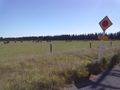
Yip, them be cows it that there paddock and a hash point in front.
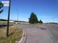
Street signs give proof of the pudding.
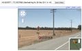
Google maps points the way.


