Difference between revisions of "2011-04-12 49 -123"
imported>Jiml m (Cutting stuff) |
m (More specific location) |
||
| (18 intermediate revisions by 5 users not shown) | |||
| Line 1: | Line 1: | ||
| − | |||
| − | |||
| − | |||
| − | |||
| − | |||
| − | |||
| − | |||
| − | |||
| − | |||
{{meetup graticule | {{meetup graticule | ||
| lat=49 | | lat=49 | ||
| Line 17: | Line 8: | ||
__NOTOC__ | __NOTOC__ | ||
== Location == | == Location == | ||
| − | + | An alley in a swanky neighbourhood a few blocks off Granville Street. | |
== Participants == | == Participants == | ||
| Line 23: | Line 14: | ||
* [[User:Robyn|Robyn]] | * [[User:Robyn|Robyn]] | ||
* [[User:Arbron|Arbron]] | * [[User:Arbron|Arbron]] | ||
| + | * [[User:MylSh|MylSh]] | ||
| + | * Jeff | ||
== Plans == | == Plans == | ||
| Line 28: | Line 21: | ||
16:00 | 16:00 | ||
| + | Rice Krispie® Treats | ||
== Expedition == | == Expedition == | ||
| − | + | ||
| + | === Arbron === | ||
| + | After seeing the hash point was close by, and seeing on the wiki page that there would be others attending, I | ||
| + | decided to do something special for this hash. I ran to the store, bought the ingredients, and made a batch of | ||
| + | chocolate chip Rice Krispie® Treats. I then proceeded to drive to the hash point and circled a couple of times | ||
| + | before realizing what looked like a proper road on Google Maps™ was in fact an alleyway. After parking, I got | ||
| + | out and saw [[User:thepiguy|Pi]] waving at me from the Hashmobile©. | ||
| + | |||
| + | === Robyn === | ||
| + | Realizing the hash point was under six kilometres from my home, and on a navigable roadway, I wracked my brains | ||
| + | for a creative and original way to arrive there. I checked the garage to see if I'd built a solar-powered | ||
| + | hovercraft yet, but it seems I haven't, so I settled on jogging. My heart rate monitor has a GPS in it, but | ||
| + | by the time I'd found my keys and my sunglasses I didn't have time to program in the coordinates. No matter, | ||
| + | I knew the intersection, and there were going to be multiple people there. I'd just follow them. | ||
| + | |||
| + | The heart monitor screamed at me the whole way. Apparently it's bad to run for thirty minutes with a heart rate | ||
| + | over 175 beats per minute. It only got over 180 on the really big hills. Apparently my heart just likes going | ||
| + | fast. I'm not sure I took exactly the optimal route, but only a five or ten minutes later than planned I arrived | ||
| + | at an intersection where Arbron and pi were competing to photograph my arrival. I had to slow down to Six Million | ||
| + | Dollar Man pace (without sound effects) to enable them to properly document it. | ||
| + | |||
| + | ===Together=== | ||
| + | We all visited the hashpoint in brief little forays, as each new person arrived, not wanting to stay too long in the alley of a swanky neighbourhood, doing geohasher things. It turned out that <i>no one</i> had brought both a GPS and the coordinates, each knowing that we could get close enough to find the group on street view alone, and assuming that someone there would have it. Fortunately google maps makes it very clear where the hashpoint is, and we made a point of stomping around the general vicinity to make sure we visited it. | ||
| + | |||
| + | We retreated to the nearest street corner and compared arm veins, musing that this really was an appropriate alley behaviour, but we had a logical reason, really. Then treats were consumed. | ||
| + | |||
| + | After standing around awhile talking about the fact we hadn't seen each other since July, some new guy biked up and asked us if we were Geohashers. Yey! | ||
== Tracklog == | == Tracklog == | ||
| − | + | Not actually a tracklog, but the log of Robyn's GPS/heart rate monitor from the jog over. Red is heart rate, blue is speed and beige is the up/down grade of the road. You can see the bits where I got lazy and walked on some of the hills. | |
| + | |||
| + | [[Image:2011-04-12.HR.jpg]] | ||
== Photos == | == Photos == | ||
| − | <!-- | + | <gallery> |
| − | Image: | + | Image:2011-04-12_49_-123_pictures.JPG|user:thepiguy and Arbron have a camera duel. |
| − | -- | + | Image:2011-04-12_49_-123_running.JPG|Robyn! |
| − | + | Image:2011-04-12_49_-123_treats.JPG|So good! | |
| + | Image:2011-04-12_49_-123_gps.JPG|I declare the geohasher to be here! | ||
| + | Image:2011-04-12_49_-123_hashers1.JPG|Geohashers take one! | ||
| + | Image:2011-04-12_49_-123_bike.JPG|A wild geohasher appears! | ||
| + | Image:2011-04-12_49_-123_hashers2.JPG|Geohashers take two! | ||
</gallery> | </gallery> | ||
== Achievements == | == Achievements == | ||
{{#vardefine:ribbonwidth|800px}} | {{#vardefine:ribbonwidth|800px}} | ||
| − | |||
| + | {{No_batteries_geohash | ||
| − | + | | latitude = 49 | |
| − | + | | longitude = -123 | |
| − | + | | date = 2011-04-12 | |
| + | | name = All participants | ||
| + | | image = | ||
| − | + | }} | |
| − | + | You may be confused as to how we can claim no batteries when there were GPS receivers present. The reason is that no one had brought the <i>coordinates</i>. We had to go by the aerial photo. | |
| − | |||
| − | |||
[[Category:Expeditions]] | [[Category:Expeditions]] | ||
| − | |||
[[Category:Expeditions with photos]] | [[Category:Expeditions with photos]] | ||
| − | |||
[[Category:Expedition without GPS]] | [[Category:Expedition without GPS]] | ||
| − | |||
| − | |||
| − | |||
[[Category:Coordinates reached]] | [[Category:Coordinates reached]] | ||
| − | + | {{location|CA|BC|MV}} | |
| − | |||
| − | |||
| − | |||
| − | |||
| − | |||
| − | |||
| − | |||
| − | |||
| − | |||
Latest revision as of 23:40, 9 August 2020
| Tue 12 Apr 2011 in 49,-123: 49.2362804, -123.1451336 geohashing.info google osm bing/os kml crox |
Location
An alley in a swanky neighbourhood a few blocks off Granville Street.
Participants
Plans
16:00
Rice Krispie® Treats
Expedition
Arbron
After seeing the hash point was close by, and seeing on the wiki page that there would be others attending, I decided to do something special for this hash. I ran to the store, bought the ingredients, and made a batch of chocolate chip Rice Krispie® Treats. I then proceeded to drive to the hash point and circled a couple of times before realizing what looked like a proper road on Google Maps™ was in fact an alleyway. After parking, I got out and saw Pi waving at me from the Hashmobile©.
Robyn
Realizing the hash point was under six kilometres from my home, and on a navigable roadway, I wracked my brains for a creative and original way to arrive there. I checked the garage to see if I'd built a solar-powered hovercraft yet, but it seems I haven't, so I settled on jogging. My heart rate monitor has a GPS in it, but by the time I'd found my keys and my sunglasses I didn't have time to program in the coordinates. No matter, I knew the intersection, and there were going to be multiple people there. I'd just follow them.
The heart monitor screamed at me the whole way. Apparently it's bad to run for thirty minutes with a heart rate over 175 beats per minute. It only got over 180 on the really big hills. Apparently my heart just likes going fast. I'm not sure I took exactly the optimal route, but only a five or ten minutes later than planned I arrived at an intersection where Arbron and pi were competing to photograph my arrival. I had to slow down to Six Million Dollar Man pace (without sound effects) to enable them to properly document it.
Together
We all visited the hashpoint in brief little forays, as each new person arrived, not wanting to stay too long in the alley of a swanky neighbourhood, doing geohasher things. It turned out that no one had brought both a GPS and the coordinates, each knowing that we could get close enough to find the group on street view alone, and assuming that someone there would have it. Fortunately google maps makes it very clear where the hashpoint is, and we made a point of stomping around the general vicinity to make sure we visited it.
We retreated to the nearest street corner and compared arm veins, musing that this really was an appropriate alley behaviour, but we had a logical reason, really. Then treats were consumed.
After standing around awhile talking about the fact we hadn't seen each other since July, some new guy biked up and asked us if we were Geohashers. Yey!
Tracklog
Not actually a tracklog, but the log of Robyn's GPS/heart rate monitor from the jog over. Red is heart rate, blue is speed and beige is the up/down grade of the road. You can see the bits where I got lazy and walked on some of the hills.

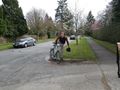
Photos
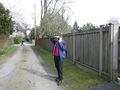
user:thepiguy and Arbron have a camera duel.
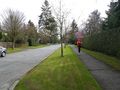
Robyn!
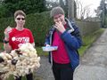
So good!
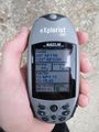
I declare the geohasher to be here!
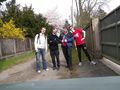
Geohashers take one!
A wild geohasher appears!
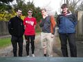
Geohashers take two!


Achievements
All participants earned the No Batteries Geohash Achievement
|
You may be confused as to how we can claim no batteries when there were GPS receivers present. The reason is that no one had brought the coordinates. We had to go by the aerial photo.