Difference between revisions of "2011-04-23 49 -122"
imported>Rhonda (→Plans) |
m (More specific location) |
||
| (11 intermediate revisions by 5 users not shown) | |||
| Line 1: | Line 1: | ||
| + | Four expeditions converged on a hillside in a happy adventure about as close to textbook as geohashing ever gets. | ||
| + | |||
<!-- If you did not specify these parameters in the template, please substitute appropriate values for IMAGE, LAT, LON, and DATE (YYYY-MM-DD format) | <!-- If you did not specify these parameters in the template, please substitute appropriate values for IMAGE, LAT, LON, and DATE (YYYY-MM-DD format) | ||
| Line 14: | Line 16: | ||
}} | }} | ||
| − | + | ||
__NOTOC__ | __NOTOC__ | ||
== Location == | == Location == | ||
| − | + | ||
| − | Adjacent to a baseball diamond in | + | Adjacent to a baseball diamond in Coquitlam. In Google satellite view there was construction next door so it was a but of an adventure, however Juventas had correctly deduced that the construction was a park expansion, meaning that it was a spot almost literally made for geohashing. |
| + | |||
== Participants == | == Participants == | ||
| − | + | * one more person whose chosen internet name I don't know | |
| + | *[[User:Osmie|Osmie]] | ||
| + | *Abigailme | ||
| + | *ZZ | ||
| + | *SoBe | ||
| + | *[[user:Rhonda|Rhonda]] | ||
| + | *[[user:Xore|Xore]] | ||
| + | *[[user:Robyn|Robyn]] | ||
| + | *[[user:Wade|Wade]] | ||
| + | * Dagny - Wade & Robyn's dragalong | ||
== Plans == | == Plans == | ||
| − | + | The geohash was so gloriously simple, in a real public park on a sunny day that the only plan posted was ... | |
| + | |||
4PM, of course! | 4PM, of course! | ||
== Expedition == | == Expedition == | ||
| − | + | ===Robyn, Wade & Dagny=== | |
| + | We have little to report beyond a pleasant Easter drive along the Barnet Highway to the park. We knew Rhonda and Xore would be there, so we looked for them as we walked along a park path towards the site. Eighteen metres away, a child sprang out and informed us that "if you're looking for something that's in the bushes, it's up there," pointing up a slope beside the path. We looked and then in the next pace we came face to face with a stranger who asked us if we were geohashing. It turned out to be no stranger to geohashing, but rather Osmie, who created many of the original graticule pages for our province, but this is the first geohash she has managed to reach. As soon as that introduction was complete, we found the rest of the group. | ||
| + | |||
| + | ===Rhonda & Xore=== | ||
| + | We had a simple, uneventful drive along highway 1 then the Lougheed into Coquitlam. Just past where the Lougheed made a sharp right, a sign directing us to the geohash indicated that we were 1.5km from our destination. Unfortunately, due to the busy street, we couldn't stop and take a photo, but you can see it for yourself any day. It said "Town Centre Park", just as Juventas had said. | ||
| + | |||
| + | We found parking in the construction zone from the photo, and realized we hadn't checked terrain view; there was a hill between the road and the baseball diamonds, which contained the stand of trees. Fortunately it wasn't too steep. Xore thought he saw geohashers in the trees, but Rhonda's GPS said those weren't the trees containing the hashpoint, plus they were kids playing. When we were closer, we saw Robyn and her crew, and joined them. | ||
| + | |||
| + | ===Osmie, Abigailme, ZZ & SoBe=== | ||
| + | After a day driving gradually eastward—birdwatching at Burnaby Lake, late lunch in Coquitlam—Osmie realized that we were within striking distance of the day's geohash. | ||
| + | This was startling, as she'd never actually made it to a meetup before, but a public park, on Saturday of a long weekend, just up the hill from Abigailme's school? Such destiny shall not be denied. | ||
| + | |||
| + | So we drove across Coquitlam to Town Centre Park, arriving about 3:45pm, and navigated by a cached Google Maps satellite view to the trees. A nerdy-looking fellow leaned against a stone wall nearby, but he had no visible GPS so Osmie said nothing. (Silly Osmie!) ZZ and SoBe played while Abigailme and Osmie sat on the hill, unsure what to expect, until Osmie wandered back down toward the path about 3:59pm. | ||
| + | |||
| + | Suddenly three separate expeditions charged in from two directions! "You must be the people I was hoping I'd run into," Osmie babbled to the person carrying a dinosaur, who turned out to be Robyn—"Oh, there's Rhonda," Robyn said, pointing behind me—"So you ''are'' geohashers," said the nerdy-looking fellow, walking up behind Wade—and thus up was met. | ||
| + | |||
| + | ===Together=== | ||
| + | Rhonda and Wade started the GPS dance while everybody else set up a picnic. As they located the spot, right on the edge of a cluster of trees and thorns, a child's voice called out "the ''nerd'' group is up there". | ||
| − | + | There were all together ten people, including two children, plus three hashcots, two chocolate cakes, three or four picnic blankets, a Twister set and lots of happy chatter. That, my friends, is how geohashing is meant to be. | |
| − | |||
== Photos == | == Photos == | ||
| − | + | ||
| − | |||
| − | |||
<gallery perrow="5"> | <gallery perrow="5"> | ||
| + | File:2011-04-23 49 -122.Barnett.jpg|Mountain view from the Barnet Highway | ||
| + | File:2011-04-23 49 -122.picnic.jpg|Nine geohashers here if you count carefully | ||
| + | File:2011-04-23 49 -122.cake.jpg|The second of two chocolate cakes | ||
| + | File:2011-04-23 49 -122.xkcd.jpg|xkcd marks the spot | ||
| + | File:2011-04-23 49 -122.group.jpg|Yay, it's everybody! | ||
| + | File:2011-04-23 49 -122.hashcots.jpg|Wump, Sophie and T-Rex | ||
</gallery> | </gallery> | ||
| Line 44: | Line 77: | ||
<!-- Add any achievement ribbons you earned below, or remove this section --> | <!-- Add any achievement ribbons you earned below, or remove this section --> | ||
| + | * Land Geohash | ||
| − | |||
| − | |||
| − | |||
| − | |||
| − | |||
| − | |||
| − | |||
| − | |||
| − | |||
| − | |||
[[Category:Expeditions]] | [[Category:Expeditions]] | ||
| − | |||
[[Category:Expeditions with photos]] | [[Category:Expeditions with photos]] | ||
| − | |||
| − | |||
| − | |||
| − | |||
| − | |||
[[Category:Coordinates reached]] | [[Category:Coordinates reached]] | ||
| − | + | {{location|CA|BC|MV}} | |
| − | |||
| − | |||
| − | |||
| − | |||
| − | |||
| − | |||
| − | |||
| − | |||
| − | |||
Latest revision as of 23:41, 9 August 2020
Four expeditions converged on a hillside in a happy adventure about as close to textbook as geohashing ever gets.
| Sat 23 Apr 2011 in 49,-122: 49.2925429, -122.7866347 geohashing.info google osm bing/os kml crox |
Location
Adjacent to a baseball diamond in Coquitlam. In Google satellite view there was construction next door so it was a but of an adventure, however Juventas had correctly deduced that the construction was a park expansion, meaning that it was a spot almost literally made for geohashing.
Participants
- one more person whose chosen internet name I don't know
- Osmie
- Abigailme
- ZZ
- SoBe
- Rhonda
- Xore
- Robyn
- Wade
- Dagny - Wade & Robyn's dragalong
Plans
The geohash was so gloriously simple, in a real public park on a sunny day that the only plan posted was ...
4PM, of course!
Expedition
Robyn, Wade & Dagny
We have little to report beyond a pleasant Easter drive along the Barnet Highway to the park. We knew Rhonda and Xore would be there, so we looked for them as we walked along a park path towards the site. Eighteen metres away, a child sprang out and informed us that "if you're looking for something that's in the bushes, it's up there," pointing up a slope beside the path. We looked and then in the next pace we came face to face with a stranger who asked us if we were geohashing. It turned out to be no stranger to geohashing, but rather Osmie, who created many of the original graticule pages for our province, but this is the first geohash she has managed to reach. As soon as that introduction was complete, we found the rest of the group.
Rhonda & Xore
We had a simple, uneventful drive along highway 1 then the Lougheed into Coquitlam. Just past where the Lougheed made a sharp right, a sign directing us to the geohash indicated that we were 1.5km from our destination. Unfortunately, due to the busy street, we couldn't stop and take a photo, but you can see it for yourself any day. It said "Town Centre Park", just as Juventas had said.
We found parking in the construction zone from the photo, and realized we hadn't checked terrain view; there was a hill between the road and the baseball diamonds, which contained the stand of trees. Fortunately it wasn't too steep. Xore thought he saw geohashers in the trees, but Rhonda's GPS said those weren't the trees containing the hashpoint, plus they were kids playing. When we were closer, we saw Robyn and her crew, and joined them.
Osmie, Abigailme, ZZ & SoBe
After a day driving gradually eastward—birdwatching at Burnaby Lake, late lunch in Coquitlam—Osmie realized that we were within striking distance of the day's geohash. This was startling, as she'd never actually made it to a meetup before, but a public park, on Saturday of a long weekend, just up the hill from Abigailme's school? Such destiny shall not be denied.
So we drove across Coquitlam to Town Centre Park, arriving about 3:45pm, and navigated by a cached Google Maps satellite view to the trees. A nerdy-looking fellow leaned against a stone wall nearby, but he had no visible GPS so Osmie said nothing. (Silly Osmie!) ZZ and SoBe played while Abigailme and Osmie sat on the hill, unsure what to expect, until Osmie wandered back down toward the path about 3:59pm.
Suddenly three separate expeditions charged in from two directions! "You must be the people I was hoping I'd run into," Osmie babbled to the person carrying a dinosaur, who turned out to be Robyn—"Oh, there's Rhonda," Robyn said, pointing behind me—"So you are geohashers," said the nerdy-looking fellow, walking up behind Wade—and thus up was met.
Together
Rhonda and Wade started the GPS dance while everybody else set up a picnic. As they located the spot, right on the edge of a cluster of trees and thorns, a child's voice called out "the nerd group is up there".
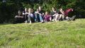
There were all together ten people, including two children, plus three hashcots, two chocolate cakes, three or four picnic blankets, a Twister set and lots of happy chatter. That, my friends, is how geohashing is meant to be.
Photos
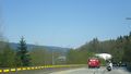
Mountain view from the Barnet Highway
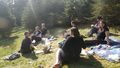
Nine geohashers here if you count carefully

The second of two chocolate cakes
xkcd marks the spot
Yay, it's everybody!
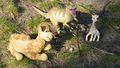
Wump, Sophie and T-Rex


Achievements
- Land Geohash