Difference between revisions of "2011-05-01 52 1"
imported>Sourcerer m |
imported>FippeBot m (Location) |
||
| (3 intermediate revisions by one other user not shown) | |||
| Line 1: | Line 1: | ||
| − | |||
| − | |||
| − | |||
| − | |||
{{meetup graticule | {{meetup graticule | ||
| lat=52 | | lat=52 | ||
| Line 8: | Line 4: | ||
| date=2011-05-01 | | date=2011-05-01 | ||
| graticule_name=Norwich | | graticule_name=Norwich | ||
| − | | graticule_link=Norwich, United Kingdom}} | + | | graticule_link=Norwich, United Kingdom |
| + | }} | ||
| + | |||
| + | == Location == | ||
| + | |||
| + | 600 metres south of Waldringfield with views over the Deben estuary. The nearest big town is Ipswich, Suffolk, UK. | ||
== Participants == | == Participants == | ||
| Line 22: | Line 23: | ||
== Photo Gallery == | == Photo Gallery == | ||
| − | <gallery | + | <gallery> |
Image:2011-05-01_52_1_Sourcerer_0.jpg|Google Earth track | Image:2011-05-01_52_1_Sourcerer_0.jpg|Google Earth track | ||
Image:2011-05-01_52_1_Sourcerer_1.jpg|View Near the Hashpoint | Image:2011-05-01_52_1_Sourcerer_1.jpg|View Near the Hashpoint | ||
| Line 32: | Line 33: | ||
Image:2011-05-01_52_1_Sourcerer_7.jpg|Lake Plughole Big Enough for a Baby | Image:2011-05-01_52_1_Sourcerer_7.jpg|Lake Plughole Big Enough for a Baby | ||
</gallery> | </gallery> | ||
| − | |||
| − | |||
| − | |||
| − | |||
== Achievements == | == Achievements == | ||
| Line 50: | Line 47: | ||
}} | }} | ||
| + | {{Sourcerer_links | ||
| + | | prev = 2011-04-09 52 1 | ||
| + | | curr = 2011-05-01 52 1 | ||
| + | | next = 2011-05-21 52 1 | ||
| + | | date = 2011-05-01 | ||
| + | }} | ||
| + | |||
| + | [[Category:Expeditions]] | ||
[[Category:Expeditions with photos]] | [[Category:Expeditions with photos]] | ||
[[Category:Coordinates reached]] | [[Category:Coordinates reached]] | ||
| − | + | {{location|GB|ENG|SFK}} | |
| − | |||
Latest revision as of 06:21, 9 August 2019
| Sun 1 May 2011 in Norwich: 52.0469730, 1.3310002 geohashing.info google osm bing/os kml crox |
Contents
Location
600 metres south of Waldringfield with views over the Deben estuary. The nearest big town is Ipswich, Suffolk, UK.
Participants
Expedition
It was May 1st and the weather was very sunny but there was a cold wind blowing in from the North Sea. The traffic this Royal Wedding weekend was light so the journey to Waldringfield was painless. Finding the hashpoint was not hard. There was a public footpath beside the estuary. This headed inland and across a wheat field (a guess as barley, oats and millet look similar when this size). The hashpoint was 20 metres off the public footpath and reachable because it was possible to step between the young wheat seedlings.
With half the Norwich graticule in the sea, expeditions are often not possible but when the point is right, the expeditions can be particularly nice with diverse terrain and in this case a pub. Wonderful.
Photo Gallery
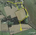
Google Earth track
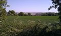
View Near the Hashpoint
View Near the Hashpoint
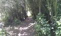
Woodland Path Near the Hashpoint
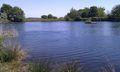
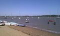
Lakes Near the Hashpoint
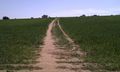
The hashpoint Wheat Field
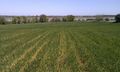
View From the Exact Point
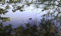
Lake Plughole Big Enough for a Baby


Achievements
Sourcerer earned the May Day Consolation Geohash
|
Expeditions and Plans
| 2011-05-01 | ||
|---|---|---|
| Frankfort, Kentucky | CaptainSpam | right near the exit ramps of I-64 to Kentucky State Highway 859 (Haley Road... |
| Norwich, United Kingdom | Sourcerer | 600 metres south of Waldringfield with views over the Deben estuary. The ne... |
| Manchester, United Kingdom | Benjw, MrsBenjw | A field right next to the M6 motorway between Crewe and Newcastle. Only a ... |
Sourcerer's Expedition Links
2011-04-09 52 1 - 2011-05-01 52 1 - 2011-05-21 52 1 - KML file download of Sourcerer's expeditions for use with Google Earth.