Difference between revisions of "2011-06-18 66 24"
imported>Isopekka (Created page with "thumb|left {{meetup graticule | lat=66 | lon=24 | date=2011-06-18 }} == Location == About 50 km to the SW from my home, in the forest about 20 m from the...") |
m (per Renaming Proposal) |
||
| (3 intermediate revisions by 2 users not shown) | |||
| Line 1: | Line 1: | ||
| − | [[Image: | + | [[Image:Gh-18-6-2011 007.JPG|thumb|left]] |
| Line 7: | Line 7: | ||
| date=2011-06-18 | | date=2011-06-18 | ||
}} | }} | ||
| + | |||
| Line 12: | Line 13: | ||
== Location == | == Location == | ||
| − | About 50 km to the SW from my home, in the forest about | + | About 50 km to the SW from my home, in the forest about 60 m from the road, in Mellajärvi. Very easy to reach. |
| Line 24: | Line 25: | ||
| − | * [[User:isopekka|isopekka]] | + | * [[User:isopekka|isopekka]] and the son. |
| Line 30: | Line 31: | ||
== Expedition == | == Expedition == | ||
| − | * By car total km | + | * By car total 100 km |
| − | * Walking total km | + | * Walking total 0.12 km |
| − | * Expedition took | + | * Expedition took 1.5h |
| − | * Physical effort (1-5): | + | * Physical effort (1-5):1 |
| + | |||
| + | |||
| + | We were at the hashpoint exactly at 4:00 p.m. The hash was an easy one. I really hoped, that Swedish hashers would appear, but no... At 4:10 we started back home. | ||
| Line 41: | Line 45: | ||
<gallery perrow=4> | <gallery perrow=4> | ||
| − | + | Image:Gh-18-6-2011 004.JPG| The Hash situates in the forest 65 m to the right from the car. | |
| + | Image:Gh-18-6-2011 003.JPG| SF-C means Finlands Caravan Camping area.(From this point 80 m to the hash). | ||
| + | Image:Gh-18-6-2011 007.JPG| On the way to the hash. Rhododendron tomentosum. | ||
| + | Image:Gh-18-6-2011 006.JPG| The Hash. | ||
| + | Image:Gh18-06-2011screen.jpg| The Proof. | ||
| + | Image:Gh-18-6-2011 005.JPG| Another proof. | ||
| + | Image:Gh-18-6-2011 009.JPG| Not so virgin nature... | ||
| + | Image:Gh-18-6-2011 010.JPG| View to the hashforest. | ||
| + | Image:Gh-18-6-2011 011.JPG| Waiting others to participate... | ||
</gallery> | </gallery> | ||
| Line 49: | Line 61: | ||
== Achievements == | == Achievements == | ||
| + | {{land geohash | ||
| + | | latitude = 66 | ||
| + | | longitude = 24 | ||
| + | | date = 2011-06-18 | ||
| + | | name = isopekka | ||
| + | }} | ||
| + | |||
| + | {{Graticule unlocked | ||
| + | | latitude = 66 | ||
| + | | longitude = 24 | ||
| + | | date = 2011-06-18 | ||
| + | | name = isopekka | ||
| + | }} | ||
| + | |||
| + | {{minesweeper geohash | name=isopekka | ranknumber=4 | graticule=Rovaniemi, Finland | e=true| n=true|sw=true |w=true }} | ||
| + | |||
| + | {{XKCD Centurion | ||
| + | |||
| + | | count = 2 | ||
| + | | name = isopekka | ||
| + | | image = | ||
| + | }} | ||
| Line 58: | Line 92: | ||
| − | [[Category: | + | [[Category:Expeditions]] |
| + | [[Category:Expeditions with photos]] | ||
| + | [[Category:Coordinates reached]] | ||
| + | {{location|FI|10}} | ||
Latest revision as of 05:53, 20 March 2024

| Sat 18 Jun 2011 in 66,24: 66.4057904, 24.6826114 geohashing.info google osm bing/os kml crox |
Contents
Location
About 50 km to the SW from my home, in the forest about 60 m from the road, in Mellajärvi. Very easy to reach.
Plan
I will be there at official meetup time 4:00 p.m. This is going to be my 2nd official meetup and 5th virgin graticule. I hope to see other hashers, so welcome! Maybe someone from Sweden could visit the hash and get the Virgin Graticule Achievement!
Participants
- isopekka and the son.
Expedition
- By car total 100 km
- Walking total 0.12 km
- Expedition took 1.5h
- Physical effort (1-5):1
We were at the hashpoint exactly at 4:00 p.m. The hash was an easy one. I really hoped, that Swedish hashers would appear, but no... At 4:10 we started back home.
Photos
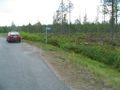
The Hash situates in the forest 65 m to the right from the car.
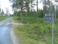
SF-C means Finlands Caravan Camping area.(From this point 80 m to the hash).
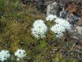
On the way to the hash. Rhododendron tomentosum.
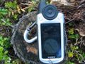
The Hash.
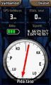
The Proof.
Another proof.
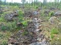
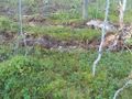
Not so virgin nature...
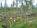
View to the hashforest.
Waiting others to participate...


Achievements
isopekka earned the Land geohash achievement
|
isopekka earned the Graticule Unlocked Achievement
|
isopekka achieved level 4 of the Minesweeper Geohash achievement
|
isopekka earned the xkcd Nullaturion achievement
|
Geohashing Expeditions and Plans on This Day
Expeditions and Plans
| 2011-06-18 | ||
|---|---|---|
| Atlanta, Georgia | NWoodruff | In the back part of a cemetery in Newnan. |
| Portland, Oregon | Jim | A house in Lake Oswego |
| Zürich, Switzerland | Crox, Elisa | Kindhausen ZH, Switzerland |
| Mannheim, Germany | ilpadre | In central Heidelberg, inside an office building. |
| Mabel Lake, British Columbia | Juventas | Silver Hills, south of Park Mountain. |
| Frankfurt am Main, Germany | Rincewind, Yakamoz | On a grass road through the fields near Butzbach-Ostheim. |
| Swindon, United Kingdom | Sourcerer | In Savernake Forest about 3.5km east of Marlborough, Wiltshire, UK. |
| Tervola, Finland | isopekka, the son. | About 50 km to the SW from my home, in the forest about 60 m from the road,... |