Difference between revisions of "2011-06-19 49 11"
imported>Srs0 m |
imported>FippeBot m (Location) |
||
| (3 intermediate revisions by 3 users not shown) | |||
| Line 15: | Line 15: | ||
| − | == | + | ==Participants== |
*[[User:srs0|srs0]] | *[[User:srs0|srs0]] | ||
*[[User:Danatar|Danatar]] | *[[User:Danatar|Danatar]] | ||
| + | ==Plans== | ||
*start at Würzburg main station at 9:43, arrive at Pölling train station at 11:51 | *start at Würzburg main station at 9:43, arrive at Pölling train station at 11:51 | ||
*walk 5 km to the hashpoint, party, eat nibs and think of [[user:thepiguy|thepiguy]], walk back | *walk 5 km to the hashpoint, party, eat nibs and think of [[user:thepiguy|thepiguy]], walk back | ||
| Line 45: | Line 46: | ||
| + | We walked 9.7 km in total. This expedition was srs0's first one in this graticule. It was the second one for Danatar, but on the [[2009-05-13 49 11|first]] one he got off at the same train station. | ||
| + | |||
| + | == Photos == | ||
<gallery perrow="4"> | <gallery perrow="4"> | ||
File:2011-06-19 49 11 danatarOnTrain.jpg|Danatar, Scott, and three GPS devices on the train. | File:2011-06-19 49 11 danatarOnTrain.jpg|Danatar, Scott, and three GPS devices on the train. | ||
File:2011-06-19 49 11 almostAtPolling.jpg|Almost at the train station. | File:2011-06-19 49 11 almostAtPolling.jpg|Almost at the train station. | ||
File:2011-06-19 49 11 trainLeaving.jpg|The train leaving after we disembark. | File:2011-06-19 49 11 trainLeaving.jpg|The train leaving after we disembark. | ||
| + | File:2011-06-19_49_11_d_enjp.jpg|we followed the England-Japan hiking trail for a while | ||
File:2011-06-19 49 11 countryside.jpg|A typical view from the walk to the hashpoint. | File:2011-06-19 49 11 countryside.jpg|A typical view from the walk to the hashpoint. | ||
File:2011-06-19 49 11 forestPathEntrance.jpg|The path that we ended up taking into the forest. | File:2011-06-19 49 11 forestPathEntrance.jpg|The path that we ended up taking into the forest. | ||
File:2011-06-19 49 11 danatarOnForestPath.jpg|Danatar on the aforementioned path. | File:2011-06-19 49 11 danatarOnForestPath.jpg|Danatar on the aforementioned path. | ||
| + | File:2011-06-19_49_11_d_crossforest.jpg|srs0 climing up the slope to the road | ||
| + | File:2011-05-19_49_11_d_tyrolsberg.jpg|town Tyrolsberg | ||
File:2011-06-19 49 11 suddenRain.jpg|Hashers prepared for the rain. | File:2011-06-19 49 11 suddenRain.jpg|Hashers prepared for the rain. | ||
File:2011-06-19 49 11 hashField.jpg|Danatar entering the hashfield. | File:2011-06-19 49 11 hashField.jpg|Danatar entering the hashfield. | ||
| − | File:2011-06-19 49 11 hashPoint.jpg|Danatar finishing the GPS dance. | + | File:2011-06-19 49 11 hashPoint.jpg|Danatar finishing the GPS dance... |
| + | File:2011-05-19_49_11_d_gps.jpg|...here. | ||
| + | File:2011-06-19_49_11_d_srs0dance.jpg|srs0 doing the same and... | ||
File:2011-06-19 49 11 coordinates.jpg|Coordinates reached! | File:2011-06-19 49 11 coordinates.jpg|Coordinates reached! | ||
File:2011-06-19 49 11 hashView.jpg|The view from the hashpoint. | File:2011-06-19 49 11 hashView.jpg|The view from the hashpoint. | ||
File:2011-06-19 49 11 srs0AtHashpoint.jpg|srs0 at the hashpoint. | File:2011-06-19 49 11 srs0AtHashpoint.jpg|srs0 at the hashpoint. | ||
| + | File:2011-06-19_49_11_d_pano.jpg|panorama | ||
| + | File:2011-05-19_49_11_d_nibs.jpg|ritual handover of Canadian specialties | ||
File:2011-06-19 49 11 DanatarAtHashpoint1.jpg|Danatar, Scott, and Nibs at the hashpoint. | File:2011-06-19 49 11 DanatarAtHashpoint1.jpg|Danatar, Scott, and Nibs at the hashpoint. | ||
File:2011-06-19 49 11 DanatarAtHashpoint2.jpg|Danatar enjoying the Nibs. | File:2011-06-19 49 11 DanatarAtHashpoint2.jpg|Danatar enjoying the Nibs. | ||
File:2011-06-19 49 11 walkBack.jpg|Walking back from the hashpoint. | File:2011-06-19 49 11 walkBack.jpg|Walking back from the hashpoint. | ||
| + | File:2011-06-19_49_11_d_schwalbe.jpg|one of the swallows at the hashpoint | ||
File:2011-06-19 49 11 DanatarJump.jpg|Danatar jumping over a ditch on the way back. | File:2011-06-19 49 11 DanatarJump.jpg|Danatar jumping over a ditch on the way back. | ||
File:2011-06-19 49 11 road.jpg|Danatar walking down the road we avoided earlier by going through the forest. | File:2011-06-19 49 11 road.jpg|Danatar walking down the road we avoided earlier by going through the forest. | ||
| Line 68: | Line 80: | ||
</gallery> | </gallery> | ||
| + | |||
| + | [http://www.everytrail.com/view_trip.php?trip_id=1154330&code=dbcd39db8e22236d6ae1a93eb17427f0 Danatar's tracklog] | ||
| + | |||
| + | [[Category:Expeditions]] | ||
[[Category:Expeditions with photos]] | [[Category:Expeditions with photos]] | ||
[[Category:Coordinates reached]] | [[Category:Coordinates reached]] | ||
| − | |||
[[Category:Danatar]] | [[Category:Danatar]] | ||
| + | {{location|DE|BY|NM}} | ||
Latest revision as of 04:07, 6 August 2019
| Sun 19 Jun 2011 in Nürnberg: 49.2648826, 11.3809181 geohashing.info google osm bing/os kml crox |
Location
Today's location is in a meadow/field near Neumarkt in der Oberpfalz.
Country: Germany; state: Bayern (Bavaria, EU:DE:BY); administrative region: Oberpfalz; district: Neumarkt in der Oberpfalz
Weather: sky partly covered by clouds, sometimes rain
Participants
Plans
- start at Würzburg main station at 9:43, arrive at Pölling train station at 11:51
- walk 5 km to the hashpoint, party, eat nibs and think of thepiguy, walk back
- take return train at 14:07/15:12, be back at Würzburg 16:16/17:16
- barbeque at Danatar's place 19:00
Expedition
As I write this, I am currently flying over the UK. As such, I am keeping my promise to Danatar, although I won't be able to upload this until much later.
I was in (46,6) the past two weeks, for research purposes. This was my first of what will likely be many such research visits over the next several years. Unfortunately I did not manage to meet up with Crox, but hopefully I will in the future.
On Saturday, after finishing my two weeks in Geneva, I took the train to Würzburg to revisit my European "home graticule". Danatar met me at the train station, and we planned a few last details for the next day's geohash over dinner.
We caught the Sunday morning train to Pölling, which is 3.5km as the crow flies, but a little over 5km as the geohasher walks. We wasted no time in setting out. At one point, the road became narrow with barely any shoulder to walk on. Danatar pointed out a path into the forest, which was heading in approximately the right direction, and we decided to take as it. Unfortunately, the forest path was a logging road, and ended after a while. It mostly followed the actual road, so when the path ended we could just walk through the forest in the direction of the road until we found it.
Upon reaching the next small village, it started to rain quite heavily. We came prepared, although thankfully it didn't last long. From there, it was a relatively simple walk to the field containing the hashpoint, and then a quick trip to the hashpoint itself.
At the hashpoint, srs0 took out the packages of nibs that he had brought from Canada, and gave them to Danatar. After some celebratory nibs, we quickly headed back to the Pölling train station, and made it with a few minutes to spare.
It was great to once again visit Würzburg, see Danatar, and geohash in Europe. I'm looking forward to my next visit!
(I'm now about to leave the UK's airspace.)
We walked 9.7 km in total. This expedition was srs0's first one in this graticule. It was the second one for Danatar, but on the first one he got off at the same train station.
Photos
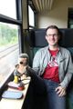
Danatar, Scott, and three GPS devices on the train.

Almost at the train station.
The train leaving after we disembark.
we followed the England-Japan hiking trail for a while
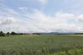
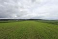
A typical view from the walk to the hashpoint.
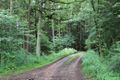
The path that we ended up taking into the forest.
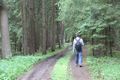
Danatar on the aforementioned path.
srs0 climing up the slope to the road
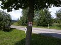
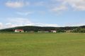
town Tyrolsberg

Hashers prepared for the rain.
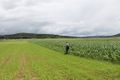
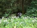
Danatar entering the hashfield.
Danatar finishing the GPS dance...
...here.
srs0 doing the same and...

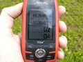
Coordinates reached!
The view from the hashpoint.

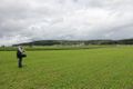
srs0 at the hashpoint.

panorama
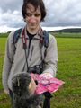
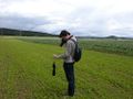
ritual handover of Canadian specialties

Danatar, Scott, and Nibs at the hashpoint.

Danatar enjoying the Nibs.
Walking back from the hashpoint.
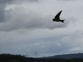
one of the swallows at the hashpoint

Danatar jumping over a ditch on the way back.
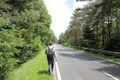
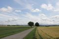
Danatar walking down the road we avoided earlier by going through the forest.
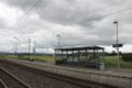
We made it back in time for the train. Now just to wait...
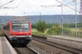
...and there it is!


