Difference between revisions of "2011-06-29 52 1"
imported>Sourcerer (Created page with "{{meetup graticule | lat=52 | lon=1 | date=2011-06-29 }} == Location == In a small patch of woodland on the north shore of South Walsham Broad, Norfolk, UK logged at [http://w...") |
m |
||
| (8 intermediate revisions by 2 users not shown) | |||
| Line 1: | Line 1: | ||
| − | {{meetup graticule | + | {{meetup graticule |
| − | | lat=52 | + | | lat=52 |
| − | | lon=1 | + | | lon=1 |
| − | | date=2011-06-29 | + | | date=2011-06-29 |
| − | }} | + | | graticule_name=Norwich |
| + | | graticule_link=Norwich, United Kingdom}} | ||
== Location == | == Location == | ||
| Line 15: | Line 16: | ||
== Expedition - Fail == | == Expedition - Fail == | ||
| − | This one was close enough to my work place for an attempt at home time. I parked opposite the Maltster's Inn and walked past the Broads Wildlife Centre towards the hash on lanes and a bridleway. I got to within 70 metres of the hashpoint but it was behind some serious looking fencing. There was an access gate that was not locked so I could have sneaked in. As it looked like a nature reserve I respected the fence | + | This one was close enough to my work place for an attempt at home time. I parked opposite the Maltster's Inn and walked past the Broads Wildlife Centre towards the hash on lanes and a bridleway. I got to within 70 metres of the hashpoint but it was behind some serious looking fencing. There was an access gate that was not locked so I could have sneaked in. As it looked like a nature reserve I respected the fence. |
The Norfolk Broads consist of rivers, canals and lakes (the broads) created by historical peat digging. They have become a wonderful nature reserve and a popular destination for inland waterway boating holidays. | The Norfolk Broads consist of rivers, canals and lakes (the broads) created by historical peat digging. They have become a wonderful nature reserve and a popular destination for inland waterway boating holidays. | ||
| Line 21: | Line 22: | ||
== Photos == | == Photos == | ||
| − | <gallery | + | <gallery> |
Image:2011-06-29_52_0_Sourcerer_00.jpg | Google Earth Track | Image:2011-06-29_52_0_Sourcerer_00.jpg | Google Earth Track | ||
Image:2011-06-29_52_0_Sourcerer_01.jpg | Inaccessible Hashpoint | Image:2011-06-29_52_0_Sourcerer_01.jpg | Inaccessible Hashpoint | ||
</gallery> | </gallery> | ||
| − | == | + | == Achievements == |
| + | |||
| + | {{OpenStreetMap Achievement | ||
| + | | latitude = 52 | ||
| + | | longitude = 1 | ||
| + | | date = 2011-06-29 | ||
| + | | OSMlink = 8584860 | ||
| + | | name = Sourcerer | ||
| + | }} | ||
| − | {{ | + | {{Sourcerer_links |
| + | | prev = 2011-06-26 52 0 | ||
| + | | curr = 2011-06-29 52 1 | ||
| + | | next = 2011-07-03 52 0 | ||
| + | | date = 2011-06-29 | ||
| + | }} | ||
| − | |||
| − | |||
[[Category:Expeditions]] | [[Category:Expeditions]] | ||
[[Category:Expeditions with photos]] | [[Category:Expeditions with photos]] | ||
[[Category:Coordinates not reached]] | [[Category:Coordinates not reached]] | ||
| + | [[Category:Not reached - No public access]] | ||
| + | {{location|GB|ENG|NFK}} | ||
Latest revision as of 11:49, 22 April 2022
| Wed 29 Jun 2011 in Norwich: 52.6736396, 1.5003789 geohashing.info google osm bing/os kml crox |
Contents
Location
In a small patch of woodland on the north shore of South Walsham Broad, Norfolk, UK logged at wikiloc.
Participants
Expedition - Fail
This one was close enough to my work place for an attempt at home time. I parked opposite the Maltster's Inn and walked past the Broads Wildlife Centre towards the hash on lanes and a bridleway. I got to within 70 metres of the hashpoint but it was behind some serious looking fencing. There was an access gate that was not locked so I could have sneaked in. As it looked like a nature reserve I respected the fence.
The Norfolk Broads consist of rivers, canals and lakes (the broads) created by historical peat digging. They have become a wonderful nature reserve and a popular destination for inland waterway boating holidays.
Photos
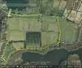
Google Earth Track
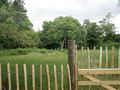
Inaccessible Hashpoint


Achievements
Sourcerer earned the OpenStreetMap achievement
|
Expeditions and Plans
| 2011-06-29 | ||
|---|---|---|
| Melbourne West, Australia | Taner | A plot of land on Long Forest Rd (between Melton and Bacchus Marsh, Victori... |
| Bharatpur, Nepal | User:thepiguy, Wyatt | Not too far from the side of a road in the bustleing metropolis of Padampur... |
| Norwich, United Kingdom | Sourcerer | In a small patch of woodland on the north shore of South Walsham Broad, Nor... |
Sourcerer's Expedition Links
2011-06-26 52 0 - 2011-06-29 52 1 - 2011-07-03 52 0 - KML file download of Sourcerer's expeditions for use with Google Earth.