Difference between revisions of "2011-07-03 52 0"
imported>Sourcerer (Created page with "== Location == In the grounds of Denston Hall 15 km south west of Bury St Edmunds, Suffolk, UK, logged at [http://www.wikiloc.com/wikiloc/view.do?id=1826225 wikiloc]. {{meetup ...") |
imported>FippeBot m (Location) |
||
| (7 intermediate revisions by 2 users not shown) | |||
| Line 1: | Line 1: | ||
| − | |||
| − | |||
| − | |||
| − | |||
{{meetup graticule | {{meetup graticule | ||
| lat=52 | | lat=52 | ||
| Line 8: | Line 4: | ||
| date=2011-07-03 | | date=2011-07-03 | ||
| graticule_name=Cambridge | | graticule_name=Cambridge | ||
| − | | graticule_link=Cambridge, United Kingdom}} | + | | graticule_link=Cambridge, United Kingdom |
| + | }} | ||
| + | |||
| + | == Location == | ||
| + | |||
| + | 1) In the grounds of Denston Hall 15 km south west of Bury St Edmunds, Suffolk, UK, logged at [http://www.wikiloc.com/wikiloc/view.do?id=1826225 wikiloc]. | ||
| + | |||
| + | [[2011-07-03 52 0]] :: [[2011-07-03 52 1]] | ||
== Participants == | == Participants == | ||
| Line 20: | Line 23: | ||
== Photo Gallery == | == Photo Gallery == | ||
| − | <gallery | + | <gallery> |
Image:2011-07-03 52 0 Sourcerer 0.jpg|Google Earth Track | Image:2011-07-03 52 0 Sourcerer 0.jpg|Google Earth Track | ||
Image:2011-07-03 52 0 Sourcerer 1.jpg|Failed to Gain Access Here Earlier | Image:2011-07-03 52 0 Sourcerer 1.jpg|Failed to Gain Access Here Earlier | ||
| Line 30: | Line 33: | ||
</gallery> | </gallery> | ||
| − | == | + | == Achievements == |
| + | |||
| + | {{OpenStreetMap Achievement | ||
| + | | latitude = 52 | ||
| + | | longitude = 0 | ||
| + | | date = 2011-07-03 | ||
| + | | OSMlink = 8623783 | ||
| + | | name = Sourcerer | ||
| + | }} | ||
| − | {{ | + | {{Sourcerer_links |
| + | | prev = 2011-06-29 52 1 | ||
| + | | curr = 2011-07-03 52 0 | ||
| + | | next = 2011-07-03 52 1 | ||
| + | | date = 2011-07-03 | ||
| + | }} | ||
| + | [[Category:Expeditions]] | ||
[[Category:Expeditions with photos]] | [[Category:Expeditions with photos]] | ||
[[Category:Coordinates reached]] | [[Category:Coordinates reached]] | ||
| − | + | {{location|GB|ENG|SFK}} | |
| − | |||
Latest revision as of 06:58, 9 August 2019
| Sun 3 Jul 2011 in Cambridge: 52.1440572, 0.5689717 geohashing.info google osm bing/os kml crox |
Contents
Location
1) In the grounds of Denston Hall 15 km south west of Bury St Edmunds, Suffolk, UK, logged at wikiloc.
2011-07-03 52 0 :: 2011-07-03 52 1
Participants
Expedition
This was a clumsy but successful expedition with two quite significant navigation errors and one semi-deliberate mistake. The public footpath had been diverted to avoid the field with the hashpoint. Where the two fields joined, there was no gate or fence or signpost so I rejoined the track of the original path as it was before the diversion. There really was no way of knowing which field the diverted path was in. The hashpoint was a few paces off this "path". Later I discovered I had followed the wrong route but I did reach the hashpoint. Denston Hall looks interesting. It has a moat.
Photo Gallery
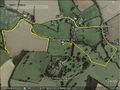
Google Earth Track
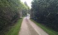
Failed to Gain Access Here Earlier
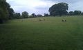
Sheep Field
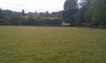
Sheep Field
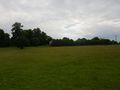
The Hall Screened by Trees
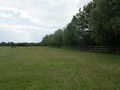
The Hashpoint
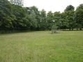
The Hashpoint


Achievements
Sourcerer earned the OpenStreetMap achievement
|
Expeditions and Plans
| 2011-07-03 | ||
|---|---|---|
| Geelong, Australia | Taner | 300 metres into the sea at Clifton Springs |
| Baltimore, Maryland | 1000miles1stStep | Freetown, MD |
| Chełm, Poland | JRK | It was lazy, rainy sunday afternoon. My sister and her husband and their ki... |
| Cambridge, United Kingdom | Sourcerer | 1) In the grounds of Denston Hall 15 km south west of Bury St Edmunds, Suff... |
| Norwich, United Kingdom | Sourcerer | 2) On the west bank of the river Alde east of Iken, Suffolk, UK, logged at ... |
Sourcerer's Expedition Links
2011-06-29 52 1 - 2011-07-03 52 0 - 2011-07-03 52 1 - KML file download of Sourcerer's expeditions for use with Google Earth.