Difference between revisions of "2011-09-19 43 -121"
imported>Michael5000 m |
imported>FippeBot m (Location) |
||
| (7 intermediate revisions by one other user not shown) | |||
| Line 5: | Line 5: | ||
}} | }} | ||
| − | [[File:2011-09-19 43 -121.JPG|thumb|none| | + | [[File:2011-09-19 43 -121.JPG|thumb|none|400 px|Driving into the forest at night.]] |
| − | |||
__NOTOC__ | __NOTOC__ | ||
== Location == | == Location == | ||
| − | + | National Forest Land in northwest Lake County. | |
== Participants == | == Participants == | ||
| Line 17: | Line 16: | ||
*[[User:Michael5000|Michael5000]] | *[[User:Michael5000|Michael5000]] | ||
| + | == Expedition == | ||
| + | |||
| + | Having been on five Expeditions over the course of the day, I checked into a motel in Bend. Driven by the restless demons of geohashing, though, I immediately set out again into the night, fortified myself with a few drive-by burritos, and drove south through the night for an hour or so. | ||
| − | + | This last hashpoint was off of long, remote State Highway 31, not a bustling route at any time and certainly not after dark. I took a turnoff into Deschutes National Forest land, and parked maybe 600 meters from the hashpoint. | |
| + | |||
| + | It was sublime. The desert forest smelled thickly of sage and juniper in the cooling air, and the darkness and silence were absolute. The stars burned intensely overhead with that intensity that we city-people so seldom see. With the exception of a single truck passing on the highway, I was the only human for miles around. It was really great. And I was really glad that, after a recent geohashing nightfall misadventure, I had bought a flashlight for the truck. The only thing that would have made it better would have been closed-toe shoes. | ||
| + | |||
| + | Using the GPS, I hiked in to the hashpoint and more or less took pictures. It's kind of hard to get the real feel of the immense dome of the firmament hung brightwhite o'er the forest on a pocket camera, though. So I just stood there for awhile enjoying the uniqueness of the experience. | ||
| + | Then, I started back towards the truck. After a while, it occurred to me that in the dark, without reference to usual landmarks, it was possible that I shouldn't rely on my sense of direction. I checked my GPS. I was heading almost directly away from the truck. This happened two more times before I finally managed to complete the four or five minute walk. | ||
== Photos == | == Photos == | ||
| − | |||
| − | |||
| − | |||
<gallery perrow="5"> | <gallery perrow="5"> | ||
| + | File:2011-09-19 43 -121.JPG|Into the forest at night! | ||
| + | File:2011-09-19 43 -121 1.JPG|Looking up from the hashpoint location... | ||
| + | File:2011-09-19 43 -121 2.JPG|...as confirmed by the hashscot. | ||
| + | File:2011-09-19 43 -121 3.JPG|View from the hashpoint (no flash). | ||
| + | File:2011-09-19 43 -121 4.JPG|View from the hashpoint (flash). | ||
| + | File:2011-09-19 43 -121 5.JPG|Fortunately, I bought a little flashlight for the Expedition Vehicle after a recent fiasco. | ||
| + | File:2011-09-19 43 -121 6.JPG|It's always nice to return to the armor and mobility of one's cybernetic shell. | ||
</gallery> | </gallery> | ||
| Line 34: | Line 45: | ||
| − | + | *First Expedition (by me) to the LaPine graticule. | |
| + | *First Expedition to Lake County. | ||
| + | *Twelfth Expedition of the [[Endurance Geohashing]] series. | ||
| + | |||
| + | {{Multihash2 | count = 4 | date = 2011-09-19 | name = [[User:Michael5000|Michael5000]]}} | ||
| + | * Six attempts and four successes in one long day. | ||
| + | |||
| + | |||
| + | {{Minesweeper geohash | ||
| + | | graticule = [[Springfield, Oregon]] | ||
| + | | ranknumber = 6 | ||
| + | | ne = true | ||
| + | | e = true | ||
| + | | se = true | ||
| + | | w = true if graticule to the west has been hashed (optional) | ||
| + | | nw = true if graticule to the northwest has been hashed (optional) | ||
| + | | n = true | ||
| + | | name = [[User:Michael5000|Michael5000]] | ||
| + | }} | ||
| + | |||
| + | {{Minesweeper geohash | ||
| + | | graticule = [[Bend, Oregon]] | ||
| + | | ranknumber = 5 | ||
| + | | n = true | ||
| + | | s = true | ||
| + | | e = true | ||
| + | | nw = true | ||
| + | | w = true | ||
| + | | name = [[User:Michael5000|Michael5000]] | ||
| + | }} | ||
| + | |||
| + | {{Minesweeper geohash | ||
| + | | graticule = [[La Pine, Oregon]] | ||
| + | | ranknumber = 5 | ||
| + | | n = true | ||
| + | | ne = true | ||
| + | | nw = true | ||
| + | | sw = true | ||
| + | | s = true | ||
| + | | name = [[User:Michael5000|Michael5000]] | ||
| + | }} | ||
| − | |||
| − | |||
| − | |||
| − | |||
| − | |||
[[Category:Expeditions]] | [[Category:Expeditions]] | ||
| − | |||
[[Category:Expeditions with photos]] | [[Category:Expeditions with photos]] | ||
| − | |||
| − | |||
| − | |||
| − | |||
| − | |||
[[Category:Coordinates reached]] | [[Category:Coordinates reached]] | ||
| − | + | {{location|US|OR|LK}} | |
| − | |||
| − | |||
| − | |||
| − | |||
| − | |||
| − | |||
| − | |||
| − | |||
| − | |||
Latest revision as of 00:54, 13 August 2019
| Mon 19 Sep 2011 in 43,-121: 43.4223289, -121.2688817 geohashing.info google osm bing/os kml crox |

Location
National Forest Land in northwest Lake County.
Participants
Expedition
Having been on five Expeditions over the course of the day, I checked into a motel in Bend. Driven by the restless demons of geohashing, though, I immediately set out again into the night, fortified myself with a few drive-by burritos, and drove south through the night for an hour or so.
This last hashpoint was off of long, remote State Highway 31, not a bustling route at any time and certainly not after dark. I took a turnoff into Deschutes National Forest land, and parked maybe 600 meters from the hashpoint.
It was sublime. The desert forest smelled thickly of sage and juniper in the cooling air, and the darkness and silence were absolute. The stars burned intensely overhead with that intensity that we city-people so seldom see. With the exception of a single truck passing on the highway, I was the only human for miles around. It was really great. And I was really glad that, after a recent geohashing nightfall misadventure, I had bought a flashlight for the truck. The only thing that would have made it better would have been closed-toe shoes.
Using the GPS, I hiked in to the hashpoint and more or less took pictures. It's kind of hard to get the real feel of the immense dome of the firmament hung brightwhite o'er the forest on a pocket camera, though. So I just stood there for awhile enjoying the uniqueness of the experience.
Then, I started back towards the truck. After a while, it occurred to me that in the dark, without reference to usual landmarks, it was possible that I shouldn't rely on my sense of direction. I checked my GPS. I was heading almost directly away from the truck. This happened two more times before I finally managed to complete the four or five minute walk.
Photos
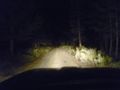
Into the forest at night!
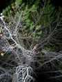
Looking up from the hashpoint location...
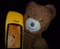
...as confirmed by the hashscot.

View from the hashpoint (no flash).
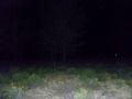
View from the hashpoint (flash).
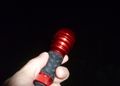
Fortunately, I bought a little flashlight for the Expedition Vehicle after a recent fiasco.
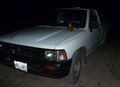
It's always nice to return to the armor and mobility of one's cybernetic shell.


Achievements
- First Expedition (by me) to the LaPine graticule.
- First Expedition to Lake County.
- Twelfth Expedition of the Endurance Geohashing series.
Michael5000 earned the Multihash Achievement
|
- Six attempts and four successes in one long day.
Michael5000 achieved level 6 of the Minesweeper Geohash achievement
|
Michael5000 achieved level 5 of the Minesweeper Geohash achievement
|
Michael5000 achieved level 5 of the Minesweeper Geohash achievement
|