Difference between revisions of "2011-10-12 40 -74"
imported>Jevanyn (An expedition message sent via Geohash Droid for Android.) |
m (Replacing http://wiki.xkcd.com/geohashing/No_Batteries_Geohash with No Batteries Geohash) |
||
| (22 intermediate revisions by 6 users not shown) | |||
| Line 1: | Line 1: | ||
| − | |||
| − | |||
| − | |||
| − | |||
| − | |||
| − | |||
| − | |||
| − | |||
| − | |||
| − | |||
{{meetup graticule | {{meetup graticule | ||
| lat=40 | | lat=40 | ||
| Line 15: | Line 5: | ||
}} | }} | ||
| − | + | ||
__NOTOC__ | __NOTOC__ | ||
== Location == | == Location == | ||
| − | + | ||
| + | Springfield, NJ - On Mountain Ave. 3 houses NE of where it crosses Shunpike Rd. - [[User:Spindizzy|Spindizzy]] | ||
== Participants == | == Participants == | ||
| − | + | ||
| + | * [[User:Spindizzy|Spindizzy]] at about 3:30 | ||
| + | * [[User:Jevanyn|Jevanyn]] at about 5:30 | ||
== Plans == | == Plans == | ||
| − | + | ||
| + | *Looks worthy of a [[No Batteries Geohash|No Batteries]] attempt for me. The hash appears to be in the middle of a tree near a sidewalk. Won't be able to do a meetup, however, due to a prior commitment. - [[User:Spindizzy|Spindizzy]] 13:43, 12 October 2011 | ||
| + | |||
| + | *Wow, really? That's less than a mile from where I work. Be there around 5PM. -- [[User:Jevanyn|Jevanyn]] [http://www.openstreetmap.org/?lat=40.68859366&lon=-74.31623274&zoom=16&layers=B000FTF @40.6886,-74.3162] 13:00, 12 October 2011 (EDT) | ||
== Expedition == | == Expedition == | ||
| − | + | [[User:Spindizzy|Spindizzy]]: Drove to this location and arrived around 3:30 pm DST. Mountain Avenue is very busy with "No Standing" signs so I parked on a side street. Not wanting to look too conspicuous, I took a couple of photos - walking up to the hash and one from across the street, where there was a memorial park where I took some photos. There was a crossing guard to get across the street and I did not want to look suspicious. | |
== Tracklog == | == Tracklog == | ||
| Line 33: | Line 29: | ||
== Photos == | == Photos == | ||
| − | < | + | |
| − | Image: | + | === Spindizzy === |
| + | |||
| + | <gallery> | ||
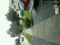
| + | Image:2011-10-12 40 -74 Approaching.JPG | Walking to the geohash | ||
| + | Image:2011-10-12 40 -74 Google Earth.jpg | Google Earth view | ||
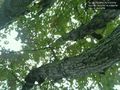
| + | Image:2011-10-12 40 -74 The Larch.JPG | The Larch | ||
| + | Image:2011-10-12 40-74 Veterans1.JPG |Veteran's park 1 | ||
| + | Image:2011-10-12 40 -74 Veterans2 .JPG |Veteran's park 2 | ||
| + | </gallery> | ||
| + | Sorry, no photos of me - camera is a hand-held and difficult to self-portrait. | ||
| + | <!-- - | ||
| + | |||
| + | Admins - I uploaded these but only the Google Earth view one is displayed. Where have I gone wrong? | ||
| + | |||
| + | You had JPG as jpg for some of the files, and spacing problems on others. - ~~~~ | ||
--> | --> | ||
| − | <gallery | + | |
| + | === Jevanyn === | ||
| + | <gallery> | ||
| + | |||
| + | Image:2011-10-12_40_-74_17-22-12-177.jpg | Bush at the hashpoint [http://www.openstreetmap.org/?lat=40.7025&lon=-74.3197&zoom=16&layers=B000FTF @40.7025,-74.3197] | ||
| + | |||
| + | Image:2011-10-12_40_-74_17-23-02-445.jpg | Standing under this tree to try to stay dry (it didn't work) [http://www.openstreetmap.org/?lat=40.70251936&lon=-74.31966313&zoom=16&layers=B000FTF @40.7025,-74.3197] | ||
| + | |||
| + | Image:2011-10-12_40_-74_17-23-52-358.jpg | Me and Mr. Bush [http://www.openstreetmap.org/?lat=40.70252015&lon=-74.31965987&zoom=16&layers=B000FTF @40.7025,-74.3197] | ||
</gallery> | </gallery> | ||
| Line 43: | Line 61: | ||
<!-- Add any achievement ribbons you earned below, or remove this section --> | <!-- Add any achievement ribbons you earned below, or remove this section --> | ||
| + | {{land geohash | ||
| + | |||
| + | | latitude = 40 | ||
| + | | longitude = -74 | ||
| + | | date = 2011-10-12 | ||
| + | | name = [[User:Spindizzy | Spindizzy]] | ||
| + | |||
| + | }} | ||
| + | {{No_batteries_geohash | ||
| − | + | | latitude = 40 | |
| − | + | | longitude = -74 | |
| − | [[ | + | | date = 2011-10-12 |
| + | | name = [[User:Spindizzy|Spindizzy]] | ||
| + | |||
| + | }} | ||
| + | {{A Tale of Two Hashes | latitude = 40 | longitude = -74 | date = 2011-10-12 | ||
| + | | name = [[User:Spindizzy|Spindizzy]] and [[User:Jevanyn|Jevanyn]] | user2 = [[User:Dvdllr|Dvdllr]] | place = Springfield | ||
| + | }} | ||
| − | |||
| − | |||
| − | |||
| − | |||
| − | |||
[[Category:Expeditions]] | [[Category:Expeditions]] | ||
| − | |||
[[Category:Expeditions with photos]] | [[Category:Expeditions with photos]] | ||
| − | |||
[[Category:Expedition without GPS]] | [[Category:Expedition without GPS]] | ||
| − | |||
| − | |||
| − | |||
[[Category:Coordinates reached]] | [[Category:Coordinates reached]] | ||
| − | + | {{location|US|NJ|UN}} | |
| − | |||
| − | |||
| − | |||
| − | |||
| − | |||
| − | |||
| − | |||
| − | |||
| − | |||
Latest revision as of 11:19, 19 February 2020
| Wed 12 Oct 2011 in 40,-74: 40.7024872, -74.3197296 geohashing.info google osm bing/os kml crox |
Location
Springfield, NJ - On Mountain Ave. 3 houses NE of where it crosses Shunpike Rd. - Spindizzy
Participants
Plans
- Looks worthy of a No Batteries attempt for me. The hash appears to be in the middle of a tree near a sidewalk. Won't be able to do a meetup, however, due to a prior commitment. - Spindizzy 13:43, 12 October 2011
- Wow, really? That's less than a mile from where I work. Be there around 5PM. -- Jevanyn @40.6886,-74.3162 13:00, 12 October 2011 (EDT)
Expedition
Spindizzy: Drove to this location and arrived around 3:30 pm DST. Mountain Avenue is very busy with "No Standing" signs so I parked on a side street. Not wanting to look too conspicuous, I took a couple of photos - walking up to the hash and one from across the street, where there was a memorial park where I took some photos. There was a crossing guard to get across the street and I did not want to look suspicious.
Tracklog
Photos
Spindizzy
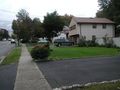
Walking to the geohash
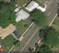
Google Earth view
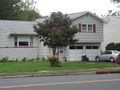
The Larch

Veteran's park 1
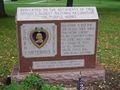
Veteran's park 2


Sorry, no photos of me - camera is a hand-held and difficult to self-portrait.
Jevanyn
Bush at the hashpoint @40.7025,-74.3197
Standing under this tree to try to stay dry (it didn't work) @40.7025,-74.3197
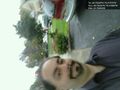
Me and Mr. Bush @40.7025,-74.3197


Achievements
Spindizzy earned the Land geohash achievement
|
Spindizzy earned the No Batteries Geohash Achievement
|
