Difference between revisions of "2011-10-28 42 -88"
imported>RocketMac |
imported>FippeBot m (Location) |
||
| (One intermediate revision by one other user not shown) | |||
| Line 1: | Line 1: | ||
| − | |||
| − | |||
| − | |||
| − | |||
| − | |||
| − | |||
| − | |||
| − | |||
| − | |||
{{meetup graticule | {{meetup graticule | ||
| lat=42 | | lat=42 | ||
| Line 64: | Line 55: | ||
}} | }} | ||
| − | |||
| − | |||
| − | |||
| − | |||
| − | |||
| − | |||
| − | |||
| − | |||
[[Category:Expeditions]] | [[Category:Expeditions]] | ||
[[Category:Expeditions with photos]] | [[Category:Expeditions with photos]] | ||
| − | + | ||
| − | |||
| − | |||
| − | |||
| − | |||
| − | |||
| − | |||
[[Category:Coordinates reached]] | [[Category:Coordinates reached]] | ||
| − | + | {{location|US|WI|MU}} | |
| − | |||
| − | |||
| − | |||
| − | |||
| − | |||
| − | |||
| − | |||
| − | |||
| − | |||
Latest revision as of 01:21, 13 August 2019
| Fri 28 Oct 2011 in 42,-88: 42.9241187, -88.0558213 geohashing.info google osm bing/os kml crox |
Location
Just feet off a road near our main grocery store.
Participants
Plans
I have spent this week working Chicago: leaving the house at 5:30am, getting on a train, spending a full day in the loop, and getting home after 7pm. Two of those days had reachable hashpoints, but required a little driving. When I saw that today's was not far from my house, I had to go.
Expedition
Today was exam day, so training was short. I had selected the early session which let me out a little after noon. That was perfect to be able to attend a geocaching event and then find a couple other caches before catching an early train.
Once I was back in town and in my car, I made off to the hashpoint and took GPS captures and a couple of photos. Still hoping to make a Pub Geohash some day, not only was there not a pub in sight, but Yelp! couldn't even find one within a mile. I checked for hash collisions as well and once again it was not to be.
Photos

Me at the site
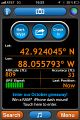
GPS Reading
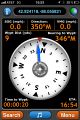
Distance
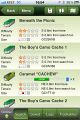
No geocaches...

...and no pub either


Achievements
RocketMac earned the Land geohash achievement
|
RocketMac has visited an Easy Geohash
|