Difference between revisions of "2011-11-29 43 -88"
imported>RocketMac (→Participants) |
imported>FippeBot m (Location) |
||
| (8 intermediate revisions by 2 users not shown) | |||
| Line 1: | Line 1: | ||
| − | |||
| − | |||
| − | |||
| − | |||
| − | |||
| − | |||
| − | |||
| − | |||
| − | |||
| − | |||
{{meetup graticule | {{meetup graticule | ||
| lat=43 | | lat=43 | ||
| Line 15: | Line 5: | ||
}} | }} | ||
| − | |||
| − | |||
== Location == | == Location == | ||
| − | |||
The intersection of Hardwood and Wauwatosa in Wauwatosa, WI | The intersection of Hardwood and Wauwatosa in Wauwatosa, WI | ||
== Participants == | == Participants == | ||
| − | |||
* [[User:RocketMac|RocketMac]] - Just before flying out to Houston for the week | * [[User:RocketMac|RocketMac]] - Just before flying out to Houston for the week | ||
== Plans == | == Plans == | ||
| − | + | I was scheduled to catch a 1:00pm plane, but was considering stopping at [http://maps.google.com/maps/place?cid=8993147196668756319 Alterra] for coffee when I checked the day's coordinates... | |
== Expedition == | == Expedition == | ||
| − | + | Okay, the day's coordinates are just down the street from my [http://maps.google.com/maps/place?cid=8993147196668756319 favorite coffeehouse] and right on the corner of an intersection. I haven't been to a geohash all month. This had to change! | |
| + | |||
| + | Originally, a coworker was going to pick me up at 11:00 to get me to the airport. I had been debating going out of my way for coffee at 9:30 when I saw the day's coordinates on a map. | ||
| + | |||
| + | Thinking quickly, I jumped in the car and was off for coffee after all. Halfway there, I decided to call my coworker and push back the pickup to 11:30. This gave me time. Sadly, the line at coffee was long, but I still made it to the hashpoint with time to take some pictures. I used to live nearby and would visit the Starbucks or Baskin Robins in the adjacent strip mall semi-regularly. | ||
| + | |||
| + | Sadly, I now needed to hurry home, so I couldn't earn the [[Pub Geohash]] or [[GeoSquishy]] achievements that were right there asking for it. | ||
| + | |||
| + | Walking back to my car, I passed an electrical box with a bunch of stickers on it, including the "creepy girl" picture that is the clue for a [http://coord.info/GC2V92W fun geocache] so I snapped a picture. The cache owner of that one likes to know when more of that sticker are found so he can add them to the cache. | ||
| + | |||
| + | I was going for the [[No Batteries Geohash]] so I wanted to leave my GPS in my pocket, but I wanted to have the GPX file for proof. I intended to start my GPS tracking when I left the house, but I forgot. Then I was going to start it when I left the coffeehouse, but I forgot. Finally, I started it when I got out of my car... and forgot to turn it off before flying to Houston, TX! | ||
== Tracklog == | == Tracklog == | ||
| − | + | I'll have to see if my GPS still has that log file. | |
== Photos == | == Photos == | ||
| − | |||
| − | |||
| − | |||
<gallery perrow="5"> | <gallery perrow="5"> | ||
Image:2011-11-29 43 -88 01.jpg | The Grin (w/cross street overhead) | Image:2011-11-29 43 -88 01.jpg | The Grin (w/cross street overhead) | ||
| Line 49: | Line 42: | ||
== Achievements == | == Achievements == | ||
{{#vardefine:ribbonwidth|800px}} | {{#vardefine:ribbonwidth|800px}} | ||
| − | + | {{No_batteries_geohash | |
| − | + | | latitude = 43 | |
| − | + | | longitude = -88 | |
| − | + | | date = 2011-11-29 | |
| − | + | | name = RocketMac | |
| − | + | | image = | |
| − | + | }} | |
| − | + | {{land geohash | |
| − | + | | latitude = 43 | |
| − | + | | longitude = -88 | |
| − | + | | date = 2011-11-29 | |
| + | | name = RocketMac | ||
| + | | image = | ||
| + | }} | ||
| + | {{Easy_geohash | ||
| + | | latitude = 43 | ||
| + | | longitude = -88 | ||
| + | | date = 2011-11-29 | ||
| + | | name = RocketMac | ||
| + | | image = | ||
| + | }} | ||
| − | |||
[[Category:Expeditions]] | [[Category:Expeditions]] | ||
| − | |||
[[Category:Expeditions with photos]] | [[Category:Expeditions with photos]] | ||
| − | |||
[[Category:Expedition without GPS]] | [[Category:Expedition without GPS]] | ||
| − | |||
| − | |||
| − | |||
[[Category:Coordinates reached]] | [[Category:Coordinates reached]] | ||
| − | + | {{location|US|WI|MU}} | |
| − | |||
| − | |||
| − | |||
| − | |||
| − | |||
| − | |||
| − | |||
| − | |||
| − | |||
Latest revision as of 01:37, 13 August 2019
| Tue 29 Nov 2011 in 43,-88: 43.0501552, -88.0067851 geohashing.info google osm bing/os kml crox |
Location
The intersection of Hardwood and Wauwatosa in Wauwatosa, WI
Participants
- RocketMac - Just before flying out to Houston for the week
Plans
I was scheduled to catch a 1:00pm plane, but was considering stopping at Alterra for coffee when I checked the day's coordinates...
Expedition
Okay, the day's coordinates are just down the street from my favorite coffeehouse and right on the corner of an intersection. I haven't been to a geohash all month. This had to change!
Originally, a coworker was going to pick me up at 11:00 to get me to the airport. I had been debating going out of my way for coffee at 9:30 when I saw the day's coordinates on a map.
Thinking quickly, I jumped in the car and was off for coffee after all. Halfway there, I decided to call my coworker and push back the pickup to 11:30. This gave me time. Sadly, the line at coffee was long, but I still made it to the hashpoint with time to take some pictures. I used to live nearby and would visit the Starbucks or Baskin Robins in the adjacent strip mall semi-regularly.
Sadly, I now needed to hurry home, so I couldn't earn the Pub Geohash or GeoSquishy achievements that were right there asking for it.
Walking back to my car, I passed an electrical box with a bunch of stickers on it, including the "creepy girl" picture that is the clue for a fun geocache so I snapped a picture. The cache owner of that one likes to know when more of that sticker are found so he can add them to the cache.
I was going for the No Batteries Geohash so I wanted to leave my GPS in my pocket, but I wanted to have the GPX file for proof. I intended to start my GPS tracking when I left the house, but I forgot. Then I was going to start it when I left the coffeehouse, but I forgot. Finally, I started it when I got out of my car... and forgot to turn it off before flying to Houston, TX!
Tracklog
I'll have to see if my GPS still has that log file.
Photos

The Grin (w/cross street overhead)
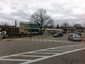
View of the area
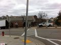
View of the area
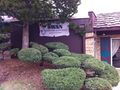
View of the area
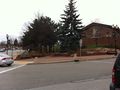
View of the area
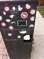
Hint for "Who's That Girl" geocache


Achievements
RocketMac earned the No Batteries Geohash Achievement
|
RocketMac earned the Land geohash achievement
|
RocketMac has visited an Easy Geohash
|