Difference between revisions of "2012-01-15 46 -122"
imported>Michael5000 (→Photos) |
imported>FippeBot m (Location) |
||
| (6 intermediate revisions by one other user not shown) | |||
| Line 28: | Line 28: | ||
The Mount St. Helens graticule is a tough one to crack, so when I saw that there was a hashpoint close to a freeway exit this weekend I decided to pounce on it. It was a bit of a drive, but then I like bits of drives. There has been rare low-altitude snow in the region this weekend, which made the drive more pretty than usual. | The Mount St. Helens graticule is a tough one to crack, so when I saw that there was a hashpoint close to a freeway exit this weekend I decided to pounce on it. It was a bit of a drive, but then I like bits of drives. There has been rare low-altitude snow in the region this weekend, which made the drive more pretty than usual. | ||
| − | From the freeway, McClure | + | From the freeway, McClure Road took me up a hill to a gate to a logging road that immediately forked in two. I chose the left road -- correctly, I think -- and a slight, gradual rise in elevation soon took me into ankle-deep snow. The forest has thickened considerably since the aerial images available online, so the final four hundred feet required ducking and weaving through a maze of animal trails through branches and undergrowth thick with melting snow. But, I made it to the hashpoint. |
By the time I got back to the logging road, I was completely soaked. Back at the truck, I turned on the heater and the fan and was more or less dry within a half hour. | By the time I got back to the logging road, I was completely soaked. Back at the truck, I turned on the heater and the fan and was more or less dry within a half hour. | ||
| Line 44: | Line 44: | ||
File:2012-01-15 46 -122 hash4.JPG|Exactly! | File:2012-01-15 46 -122 hash4.JPG|Exactly! | ||
File:2012-01-15 46 -122 me.JPG|Myself | File:2012-01-15 46 -122 me.JPG|Myself | ||
| − | File:2012-01-15 46 -122 bear.JPG|Associate | + | File:2012-01-15 46 -122 bear.JPG|Associate Hashscot and Cold-Weather Consultant |
</gallery> | </gallery> | ||
| Line 51: | Line 51: | ||
{{#vardefine:ribbonwidth|800px}} | {{#vardefine:ribbonwidth|800px}} | ||
<!-- Add any achievement ribbons you earned below, or remove this section --> | <!-- Add any achievement ribbons you earned below, or remove this section --> | ||
| + | |||
| + | *My First Expedition to the [[Mt. St. Helens, Washington]] graticule. | ||
| + | *My First Expedition to Lewis County. | ||
| + | |||
| + | |||
| + | {{Minesweeper geohash | ||
| + | | graticule = [[Portland, Oregon]] | ||
| + | | ranknumber = 8 | ||
| + | | n = true | ||
| + | | ne = true if graticule to the northeast has been hashed (optional) | ||
| + | | e = true if graticule to the east has been hashed (optional) | ||
| + | | se = true if graticule to the southeast has been hashed (optional) | ||
| + | | s = true if graticule to the south has been hashed (optional) | ||
| + | | sw = true if graticule to the southwest has been hashed (optional) | ||
| + | | w = true if graticule to the west has been hashed (optional) | ||
| + | | nw = true if graticule to the northwest has been hashed (optional) | ||
| + | | name = [[User:Michael5000|Michael5000]] | ||
| + | }} | ||
| + | |||
| + | {{Minesweeper geohash | ||
| + | | graticule = [[Astoria, Oregon]] | ||
| + | | ranknumber = 7 | ||
| + | | n = true | ||
| + | | ne = true if graticule to the northeast has been hashed (optional) | ||
| + | | e = true if graticule to the east has been hashed (optional) | ||
| + | | se = true if graticule to the southeast has been hashed (optional) | ||
| + | | s = true if graticule to the south has been hashed (optional) | ||
| + | | sw = true if graticule to the southwest has been hashed (optional) | ||
| + | | w = true if graticule to the west has been hashed (optional) | ||
| + | |||
| + | | name = [[User:Michael5000|Michael5000]] | ||
| + | }} | ||
| + | |||
| + | {{Minesweeper geohash | ||
| + | | graticule = [[McMinnville, Oregon]] | ||
| + | | ranknumber = 7 | ||
| + | | n = true | ||
| + | | ne = true | ||
| + | | e = true if graticule to the east has been hashed (optional) | ||
| + | | se = true | ||
| + | | s = true if graticule to the west has been hashed (optional) | ||
| + | | w = true if graticule to the west has been hashed (optional) | ||
| + | | nw = true | ||
| + | | name = [[User:Michael5000|Michael5000]] | ||
| + | }} | ||
| + | |||
| + | {{Minesweeper geohash | ||
| + | | graticule = [[Mt. St. Helens, Washington]] | ||
| + | | ranknumber = 7 | ||
| + | | n = true | ||
| + | | e = true | ||
| + | | se = true | ||
| + | | s = true | ||
| + | | sw = true | ||
| + | | w = true | ||
| + | | nw = true | ||
| + | | name = [[User:Michael5000|Michael5000]] | ||
| + | }} | ||
| + | |||
| + | {{Minesweeper geohash | ||
| + | | graticule = [[The Dalles, Oregon]] | ||
| + | | ranknumber = 6 | ||
| + | | n = true | ||
| + | | se = true | ||
| + | | s = true | ||
| + | | sw = true | ||
| + | | w = true | ||
| + | | nw = true | ||
| + | | name = [[User:Michael5000|Michael5000]] | ||
| + | }} | ||
| + | |||
| Line 56: | Line 127: | ||
[[Category:Expeditions with photos]] | [[Category:Expeditions with photos]] | ||
[[Category:Coordinates reached]] | [[Category:Coordinates reached]] | ||
| + | {{location|US|WA|LE}} | ||
Latest revision as of 02:05, 13 August 2019
| Sun 15 Jan 2012 in 46,-122: 46.4493384, -122.9166824 geohashing.info google osm bing/os kml crox |
Location
In the woods south of Winlock, Washington.
Participants
Expedition
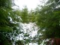
The Mount St. Helens graticule is a tough one to crack, so when I saw that there was a hashpoint close to a freeway exit this weekend I decided to pounce on it. It was a bit of a drive, but then I like bits of drives. There has been rare low-altitude snow in the region this weekend, which made the drive more pretty than usual.
From the freeway, McClure Road took me up a hill to a gate to a logging road that immediately forked in two. I chose the left road -- correctly, I think -- and a slight, gradual rise in elevation soon took me into ankle-deep snow. The forest has thickened considerably since the aerial images available online, so the final four hundred feet required ducking and weaving through a maze of animal trails through branches and undergrowth thick with melting snow. But, I made it to the hashpoint.
By the time I got back to the logging road, I was completely soaked. Back at the truck, I turned on the heater and the fan and was more or less dry within a half hour.
Photos
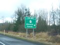
The exit from I-5
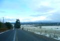
View from the entrace into the woods
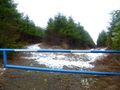
Two roads to choose from
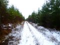
Up into the forest
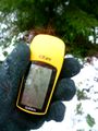
At the hashpoint
Exactly!
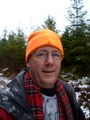
Myself
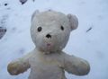
Associate Hashscot and Cold-Weather Consultant


Achievements
- My First Expedition to the Mt. St. Helens, Washington graticule.
- My First Expedition to Lewis County.
Michael5000 completed the Minesweeper Geohash achievement
|
Michael5000 achieved level 7 of the Minesweeper Geohash achievement
|
Michael5000 achieved level 7 of the Minesweeper Geohash achievement
|
Michael5000 achieved level 7 of the Minesweeper Geohash achievement
|
Michael5000 achieved level 6 of the Minesweeper Geohash achievement
|