Difference between revisions of "2012-02-13 52 -2"
imported>Sourcerer (An expedition message sent via Geohash Droid for Android.) |
m (Location correction) |
||
| (11 intermediate revisions by 2 users not shown) | |||
| Line 1: | Line 1: | ||
| − | |||
| − | |||
| − | |||
| − | |||
| − | |||
| − | |||
| − | |||
| − | |||
| − | |||
| − | |||
{{meetup graticule | {{meetup graticule | ||
| − | | lat=52 | + | | lat=52 |
| − | | lon=-2 | + | | lon=-2 |
| − | | date=2012-02-13 | + | | date=2012-02-13 |
| + | | graticule_name=Shrewsbury, UK | ||
| + | | graticule_link=Shrewsbury, United Kingdom | ||
}} | }} | ||
| − | |||
| − | |||
== Location == | == Location == | ||
| − | + | ||
| + | 1) Just over the border in Wales 1.4 km east of Hanmer Mere. | ||
| + | |||
| + | [[2012-02-13 52 -2]] :: [[2012-02-13 51 -2]] | ||
== Participants == | == Participants == | ||
| − | |||
| − | + | [[User:Sourcerer|Sourcerer]] | |
| − | |||
== Expedition == | == Expedition == | ||
| − | |||
| − | + | This doublehash came about after another weekend of beer and curry with good friends. I altered my route home to take in two new graticules and a new country too. It was easy enough to find a parking place but the first public footpath had vanished so the direct route to the hash was not available. | |
| − | + | ||
| + | Out came the droid and there was a 3G signal so I fired up the United Kingdom Ordnance Survey app. These maps are possibly the best in the world. Open Street Map comes a close second and may eventually overtake the OS maps. Best of all, the public footpaths are clearly marked. While there is a signal, it's possible to follow the footpaths in real time. | ||
| + | |||
| + | I located a second path further west and set out. It started well but the stiles were in poor repair. Eventually I reached one which had collapsed and there was a high probability of a barbed wire injury if I tried to climb the wreckage. I had to divert even further west. The lane soon re-joined the path but the access was now totally blocked. This was actually useful because I could now legally take any reasonable alternative route which just happened to take in the hashpoint. | ||
| + | |||
| + | The footpath back to the car had one or two waymarks but these failed in a farmyard. A tractor driver asked what I was doing so I explained I was looking for the path back to the main road. He cheerfully waved in the approximate direction and said it was somewhere over there. There was no waymarked route so I used the farm access road instead. | ||
| + | |||
| + | == Photo Gallery == | ||
| − | + | <gallery> | |
| − | + | Image:2012-02-13_51_-2_Sourcerer.jpg|Google Earth - Car Journey | |
| − | Image: | + | Image:2012-02-13 52 -2 Sourcerer-1.jpg|Google Earth - The Walk |
| − | -- | + | Image:2012-02-13 52 -2 Sourcerer-2.jpg|View of the hashpoint |
| − | |||
</gallery> | </gallery> | ||
| + | |||
== Achievements == | == Achievements == | ||
| − | |||
| − | |||
| + | {{Multihash2 | ||
| + | | count = 2 | ||
| + | | date = 2012-02-13 | ||
| + | | name = Sourcerer | ||
| + | }} | ||
| + | {{Border geohash achievement | ||
| + | | latitude = 52 | ||
| + | | longitude = -2 | ||
| + | | date = 2012-02-13 | ||
| + | | country1 = England | ||
| + | | country2 = Wales | ||
| + | | name = Sourcerer | ||
| + | }} | ||
| − | + | == Tracklog == | |
| − | + | ||
| − | + | [http://en.wikiloc.com/wikiloc/view.do?id=2491361 Wikiloc] | |
| − | + | {{Sourcerer_links | |
| − | + | | prev = 2012-01-21 52 1 | |
| − | + | | curr = 2012-02-13 52 -2 | |
| − | -- | + | | next = 2012-02-13 51 -2 |
| + | | date = 2012-02-13 | ||
| + | }} | ||
| − | |||
[[Category:Expeditions]] | [[Category:Expeditions]] | ||
| − | |||
[[Category:Expeditions with photos]] | [[Category:Expeditions with photos]] | ||
| − | |||
| − | |||
| − | |||
| − | |||
| − | |||
[[Category:Coordinates reached]] | [[Category:Coordinates reached]] | ||
| − | + | {{location|GB|CYM|WRC}} | |
| − | |||
| − | |||
| − | |||
| − | |||
| − | |||
| − | |||
| − | |||
| − | |||
| − | |||
Latest revision as of 20:23, 22 May 2020
| Mon 13 Feb 2012 in Shrewsbury, UK: 52.9428011, -2.7956477 geohashing.info google osm bing/os kml crox |
Contents
Location
1) Just over the border in Wales 1.4 km east of Hanmer Mere.
2012-02-13 52 -2 :: 2012-02-13 51 -2
Participants
Expedition
This doublehash came about after another weekend of beer and curry with good friends. I altered my route home to take in two new graticules and a new country too. It was easy enough to find a parking place but the first public footpath had vanished so the direct route to the hash was not available.
Out came the droid and there was a 3G signal so I fired up the United Kingdom Ordnance Survey app. These maps are possibly the best in the world. Open Street Map comes a close second and may eventually overtake the OS maps. Best of all, the public footpaths are clearly marked. While there is a signal, it's possible to follow the footpaths in real time.
I located a second path further west and set out. It started well but the stiles were in poor repair. Eventually I reached one which had collapsed and there was a high probability of a barbed wire injury if I tried to climb the wreckage. I had to divert even further west. The lane soon re-joined the path but the access was now totally blocked. This was actually useful because I could now legally take any reasonable alternative route which just happened to take in the hashpoint.
The footpath back to the car had one or two waymarks but these failed in a farmyard. A tractor driver asked what I was doing so I explained I was looking for the path back to the main road. He cheerfully waved in the approximate direction and said it was somewhere over there. There was no waymarked route so I used the farm access road instead.
Photo Gallery
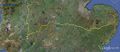
Google Earth - Car Journey
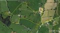
Google Earth - The Walk
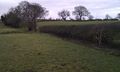
View of the hashpoint


Achievements
Sourcerer earned the Multihash Achievement
|
Sourcerer earned the Border geohash achievement
|
Tracklog
Expeditions and Plans
| 2012-02-13 | ||
|---|---|---|
| Schweinfurt, Germany | Rincewind, Mampfred | On a field near Gotha - or Tüttleben to be precise. |
| Bristol, United Kingdom | Sourcerer | 2) 1.3 km from Bagwyllydiart and on a bearing of 66o. Although in England, ... |
| Shrewsbury, United Kingdom | Sourcerer | 1) Just over the border in Wales 1.4 km east of Hanmer Mere. 2012-02-13 52 -2 :: 2012-02-13 51 -2 |
Sourcerer's Expedition Links
2012-01-21 52 1 - 2012-02-13 52 -2 - 2012-02-13 51 -2 - KML file download of Sourcerer's expeditions for use with Google Earth.