Difference between revisions of "2012-02-19 51 -1"
(Wrote up core details of retrohash) |
|||
| Line 1: | Line 1: | ||
| − | + | {{meetup graticule | |
| − | |||
| − | |||
| − | |||
| − | |||
| − | |||
| − | |||
| − | |||
| − | |||
| lat=51 | | lat=51 | ||
| lon=-1 | | lon=-1 | ||
| date=2012-02-19 | | date=2012-02-19 | ||
| − | }} | + | | retro=1 |
| − | + | }} | |
== Location == | == Location == | ||
| − | + | Field behind Hill Barn, near the Gom's Hole public footpath, in the valley beneath the hamlet of Clapton-on-the-Hill. About 4km outside the village of Bourton-on-the-Water, Gloucestershire. | |
| − | == Participants == | + | == (Retro) Participants == |
| − | + | * [[User:DanQ|Dan Q]] (as a retrohash on the same date but 19 years later, on 2021-02-19) | |
| − | -- | ||
| − | == Plans == | + | == (Retro) Plans == |
| − | + | On the second anniversary of the death of my father, a man who loved to get out into the world and get lost, I undertook [[2014-02-19 51 -0|my first geohashing expedition]]. As this seemed to be a good way to remember him I decided to repeat the experience on this, the ninth anniversary of his death, but the actual hashpoints for the day didn't look interesting... so I opted to make my way to what would have been my nearest hashpoint ''on the day he died''. | |
| − | == Expedition == | + | == (Retro) Expedition == |
| − | + | The weather looked horrible and the COVID lockdown (and working from home in general in recent years) has put me out of practice at cycling, so I thought a 40-50 mile round trip through the rolling hills of the Cotswolds was just the thing. This may have been a mistake, as my aching legs were able to testify for several days. | |
| − | + | Cycling through Witney, over the hills behind Burford, and then across the Windrush valley and into Gloucestershire was a long, arduous, and damp journey, but what really got me was the wind picking up in the afternoon and giving me a headwind to fight against all the way back home. | |
| − | |||
| − | + | Near the hashpoint I was able to lock my bike up at the junction between Sherbourne Street and Bourton Hill - a place shown on my map as "Gom's Hole" which sounds exactly like what a D&D dungeon master would have a goblin would name his bar. From there I followed the footpath towards Farringdon. As the hashpoint drew closer I began to suspect that it would be unreachable: tall walls, fences, and hedges stood on both sides of the (flooded) footpath, but at the last minute they gave way to wide meadows. I turned off the path and crossed a dyke to the hashpoint, where I had a great view of hares and deer in the valley below. Minutes later, the owner of Hill Barn came over with her dog and asked what I was doing around the back of her land and why I was taking pictures, so I explained that I'd strayed from the footpath (true) because my GPS had told me too (technically true) but I was heading back down to what I could see was the path, now (true, if misleading). | |
| − | |||
| − | |||
| − | |||
| − | |||
| − | |||
| − | + | She continued to watch me all the way back to my bike, so I changed my plans (which had been to eat a sandwich lunch and drink a pint of Guinness: my dad's beer of choice) near the hashpoint and instead I cycled away to a nearby layby to have my lunch. | |
| − | |||
| − | |||
| − | + | After a 48.3 mile round trip I got back home aching and exhausted, but pleased to have made it to this damp hashpoint. | |
| − | |||
| − | |||
| − | + | == (Retro) Tracklog == | |
| + | * ...to follow... | ||
| − | < | + | == (Retro) Photos == |
| − | + | <gallery perrow="5"> | |
| − | + | Image:2012-02-19 51 -1 A setting out.jpg | Reaching the edge of the Cotswolds by bike | |
| − | --> | + | Image:2012-02-19 51 -1 B ford.jpg | The first of the two streams that I had to ford |
| + | Image:2012-02-19 51 -1 C river path.jpg | This path has turned into more of a river | ||
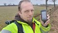
| + | Image:2012-02-19 51 -1 D GPSr.jpg | Well within the circle of uncertainty | ||
| + | Image:2012-02-19 51 -1 E panoramic.jpg | Panoramic of the hashpoint | ||
| + | Image:2012-02-19 51 -1 F silly grin.jpg | Silly grin | ||
| + | </gallery> | ||
| − | |||
| − | |||
| − | |||
[[Category:Expeditions]] | [[Category:Expeditions]] | ||
| − | |||
[[Category:Expeditions with photos]] | [[Category:Expeditions with photos]] | ||
| − | |||
| − | |||
| − | |||
| − | |||
| − | |||
[[Category:Coordinates reached]] | [[Category:Coordinates reached]] | ||
| − | + | __NOTOC__ | |
| − | |||
| − | |||
| − | |||
| − | |||
| − | |||
| − | |||
| − | |||
| − | |||
| − | |||
| − | |||
| − | |||
| − | |||
| − | |||
| − | |||
| − | |||
| − | |||
Revision as of 15:36, 21 February 2021
| Sun 19 Feb 2012 in 51,-1: 51.8569418, -1.7795905 geohashing.info google osm bing/os kml crox |
Location
Field behind Hill Barn, near the Gom's Hole public footpath, in the valley beneath the hamlet of Clapton-on-the-Hill. About 4km outside the village of Bourton-on-the-Water, Gloucestershire.
(Retro) Participants
- Dan Q (as a retrohash on the same date but 19 years later, on 2021-02-19)
(Retro) Plans
On the second anniversary of the death of my father, a man who loved to get out into the world and get lost, I undertook my first geohashing expedition. As this seemed to be a good way to remember him I decided to repeat the experience on this, the ninth anniversary of his death, but the actual hashpoints for the day didn't look interesting... so I opted to make my way to what would have been my nearest hashpoint on the day he died.
(Retro) Expedition
The weather looked horrible and the COVID lockdown (and working from home in general in recent years) has put me out of practice at cycling, so I thought a 40-50 mile round trip through the rolling hills of the Cotswolds was just the thing. This may have been a mistake, as my aching legs were able to testify for several days.
Cycling through Witney, over the hills behind Burford, and then across the Windrush valley and into Gloucestershire was a long, arduous, and damp journey, but what really got me was the wind picking up in the afternoon and giving me a headwind to fight against all the way back home.
Near the hashpoint I was able to lock my bike up at the junction between Sherbourne Street and Bourton Hill - a place shown on my map as "Gom's Hole" which sounds exactly like what a D&D dungeon master would have a goblin would name his bar. From there I followed the footpath towards Farringdon. As the hashpoint drew closer I began to suspect that it would be unreachable: tall walls, fences, and hedges stood on both sides of the (flooded) footpath, but at the last minute they gave way to wide meadows. I turned off the path and crossed a dyke to the hashpoint, where I had a great view of hares and deer in the valley below. Minutes later, the owner of Hill Barn came over with her dog and asked what I was doing around the back of her land and why I was taking pictures, so I explained that I'd strayed from the footpath (true) because my GPS had told me too (technically true) but I was heading back down to what I could see was the path, now (true, if misleading).
She continued to watch me all the way back to my bike, so I changed my plans (which had been to eat a sandwich lunch and drink a pint of Guinness: my dad's beer of choice) near the hashpoint and instead I cycled away to a nearby layby to have my lunch.
After a 48.3 mile round trip I got back home aching and exhausted, but pleased to have made it to this damp hashpoint.
(Retro) Tracklog
- ...to follow...
(Retro) Photos
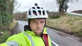
Reaching the edge of the Cotswolds by bike
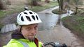
The first of the two streams that I had to ford
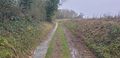
This path has turned into more of a river
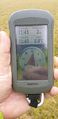
Well within the circle of uncertainty
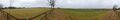
Panoramic of the hashpoint
Silly grin


