Difference between revisions of "2012-03-04 51 -1"
imported>Jiml m (Adjust Gallery and result codes) |
imported>Mampfred m |
||
| Line 1: | Line 1: | ||
| − | |||
| − | |||
| − | |||
| − | |||
| − | |||
| − | |||
| − | |||
| − | |||
| − | |||
{{meetup graticule | {{meetup graticule | ||
| lat=51 | | lat=51 | ||
| Line 53: | Line 44: | ||
| latitude = 51 | longitude = -1 | date = 2012-03-04 | name = jand | | latitude = 51 | longitude = -1 | date = 2012-03-04 | name = jand | ||
}} | }} | ||
| − | |||
| − | |||
| − | |||
| − | |||
| − | |||
[[Category:Expeditions]] | [[Category:Expeditions]] | ||
[[Category:Expeditions with photos]] | [[Category:Expeditions with photos]] | ||
[[Category:Coordinates reached]] | [[Category:Coordinates reached]] | ||
Revision as of 21:53, 9 March 2012
| Sun 4 Mar 2012 in 51,-1: 51.0667660, -1.7207607 geohashing.info google osm bing/os kml crox |
Location
The hash was located in the North East corner of Long Copse, East of Salisbury.
Participants
- Jand
- (and his parents).
Expedition
Jand
Finishing work at 4:30, my parents and I drove for just under half an hour, until we reached the gates of an estate with No Entry signs. Undeterred, we took the other fork in the road and ended up at the start of a farm track about 1.2km from the hash. Here, I got out and walked solo, reaching Long Copse by walking through ankle deep mud and thorn bushes raptor nests. Emerging miraculously unharmed, I reached the hash at 5:24 pm.
Seeing plastic on the ground, I decided to try for my Geotrash Geohash achievement, (see below).
On the walk back to the car, I got some great pictures of the sunset.
Photos
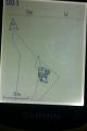
GPS showing 0m to the hash
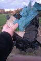
Geotrashing!
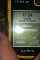
GPS showing Time and Date

My variation on the cheesy grin: the stylish raised eyebrow
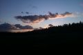
A view of the sunset over Long Copse


Achievements
- Land Geohash
jand earned the GeoTrash Geohash Achievement
|