Difference between revisions of "2012-05-04 33 -114"
imported>JesseW |
imported>JesseW (expanded writeup, and 5 pictures.) |
||
| Line 13: | Line 13: | ||
== Location == | == Location == | ||
<!-- where you've surveyed the hash to be --> | <!-- where you've surveyed the hash to be --> | ||
| + | Just across the Arizona/California border, close to Blythe, off the 10 Freeway. | ||
== Participants == | == Participants == | ||
<!-- who attended: If you link to your wiki user name in this section, your expedition will be picked up by the various statistics generated for geohashing. You may use three tildes ~ as a shortcut to automatically insert the user signature of the account you are editing with. | <!-- who attended: If you link to your wiki user name in this section, your expedition will be picked up by the various statistics generated for geohashing. You may use three tildes ~ as a shortcut to automatically insert the user signature of the account you are editing with. | ||
--> | --> | ||
| − | [[User:JesseW|JesseW]] | + | [[User:JesseW|JesseW]], one drag-along (pictured), and two other passengers (not pictured). |
== Plans == | == Plans == | ||
<!-- what were the original plans --> | <!-- what were the original plans --> | ||
| + | This was the second of three hashes I attempted on the same day. (Here's the [[2012-05-04_33_-115|first]] and [[2012-05-04 34 -112|third]].) It looked pretty close to the freeway... | ||
== Expedition == | == Expedition == | ||
<!-- how it all turned out. your narrative goes here. --> | <!-- how it all turned out. your narrative goes here. --> | ||
| − | + | The in-car navigation told us to take Dome Rock Rd. It was very clear what rock it was referring to. We got pretty close (33.645008, -114.325934), but found that to be any closer we would have to drive on a rough dirt road that our Prius was not particularly suitable for. We got some pictures, and went on to the next one. | |
| − | |||
| − | |||
== Photos == | == Photos == | ||
| Line 33: | Line 33: | ||
--> | --> | ||
<gallery perrow="5"> | <gallery perrow="5"> | ||
| + | Image:2012-05-04 33 -114 1 On the way.jpg | The navigation system. | ||
| + | Image:2012-05-04 33 -114 3 Silly grin.jpg | The very obvious ''dome'' rock. (And me.) | ||
| + | Image:2012-05-04 33 -114 4 Somewhere down this road.jpg | The dirt road that stymied us. | ||
| + | Image:2012-05-04 33 -114 5 My colleague.jpg | My colleague, and owner of the car. | ||
| + | Image:2012-05-04 33 -114 6 GPS.jpg | Proof of how close we got. | ||
</gallery> | </gallery> | ||
| Line 40: | Line 45: | ||
| − | |||
| − | |||
| − | |||
| − | |||
| − | |||
| − | |||
| − | |||
| − | |||
| − | |||
| − | |||
[[Category:Expeditions]] | [[Category:Expeditions]] | ||
| − | |||
[[Category:Expeditions with photos]] | [[Category:Expeditions with photos]] | ||
| − | |||
| − | |||
| − | |||
| − | |||
| − | |||
| − | |||
| − | |||
| − | |||
[[Category:Coordinates not reached]] | [[Category:Coordinates not reached]] | ||
| − | |||
[[Category:Not reached - Mother Nature]] when there is a natural obstacle between you and the target | [[Category:Not reached - Mother Nature]] when there is a natural obstacle between you and the target | ||
| − | |||
| − | |||
| − | |||
| − | |||
Revision as of 00:51, 16 May 2012
| Fri 4 May 2012 in 33,-114: 33.6134706, -114.2861907 geohashing.info google osm bing/os kml crox |
Location
Just across the Arizona/California border, close to Blythe, off the 10 Freeway.
Participants
JesseW, one drag-along (pictured), and two other passengers (not pictured).
Plans
This was the second of three hashes I attempted on the same day. (Here's the first and third.) It looked pretty close to the freeway...
Expedition
The in-car navigation told us to take Dome Rock Rd. It was very clear what rock it was referring to. We got pretty close (33.645008, -114.325934), but found that to be any closer we would have to drive on a rough dirt road that our Prius was not particularly suitable for. We got some pictures, and went on to the next one.
Photos
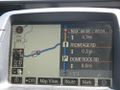
The navigation system.
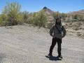
The very obvious dome rock. (And me.)
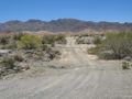
The dirt road that stymied us.
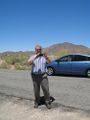
My colleague, and owner of the car.
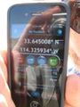
Proof of how close we got.


Achievements
when there is a natural obstacle between you and the target