Difference between revisions of "2012-05-04 33 -114"
imported>JesseW (expanded writeup, and 5 pictures.) |
imported>JesseW (→Achievements: typo) |
||
| Line 49: | Line 49: | ||
[[Category:Coordinates not reached]] | [[Category:Coordinates not reached]] | ||
| − | [[Category:Not reached - Mother Nature]] | + | [[Category:Not reached - Mother Nature]] |
Revision as of 00:52, 16 May 2012
| Fri 4 May 2012 in 33,-114: 33.6134706, -114.2861907 geohashing.info google osm bing/os kml crox |
Location
Just across the Arizona/California border, close to Blythe, off the 10 Freeway.
Participants
JesseW, one drag-along (pictured), and two other passengers (not pictured).
Plans
This was the second of three hashes I attempted on the same day. (Here's the first and third.) It looked pretty close to the freeway...
Expedition
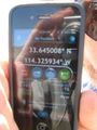
The in-car navigation told us to take Dome Rock Rd. It was very clear what rock it was referring to. We got pretty close (33.645008, -114.325934), but found that to be any closer we would have to drive on a rough dirt road that our Prius was not particularly suitable for. We got some pictures, and went on to the next one.
Photos
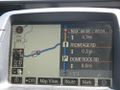
The navigation system.
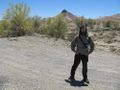
The very obvious dome rock. (And me.)
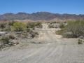
The dirt road that stymied us.
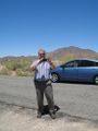
My colleague, and owner of the car.
Proof of how close we got.


