Difference between revisions of "2012-05-04 47 8"
imported>Foehammer (→Participants) |
imported>FippeBot m (Location) |
||
| (10 intermediate revisions by 2 users not shown) | |||
| Line 1: | Line 1: | ||
| − | |||
<!-- If you did not specify these parameters in the template, please substitute appropriate values for IMAGE, LAT, LON, and DATE (YYYY-MM-DD format) | <!-- If you did not specify these parameters in the template, please substitute appropriate values for IMAGE, LAT, LON, and DATE (YYYY-MM-DD format) | ||
| Line 10: | Line 9: | ||
}} | }} | ||
| − | + | ||
__NOTOC__ | __NOTOC__ | ||
== Location == | == Location == | ||
| − | + | On a hill in Uerkheim. | |
== Participants == | == Participants == | ||
| Line 19: | Line 18: | ||
== Plans == | == Plans == | ||
| − | + | Being an eager reader of [[xkcd]], I became aware of geohashing in January 2012, when the random cartoon button showed me [[The Algorithm]]. | |
| + | |||
| + | Everyday since then I checked the coordinates, but I never made it to a hash, even though I nearly hit one (30m Distance to the rails) with my train home from university. | ||
| + | |||
| + | I was very excited when I found this days hash to be very close to where I live, barely one kilometre as the crow flies from our house. Even more spectactular since I live very close to the border of this graticule. | ||
== Expedition == | == Expedition == | ||
| − | + | So it was May the 4th (be with you) and I just checked todays coordinates - they're less than one kilometre from my home! I could probably see the hash from some windows! I decided that this very hash is the best chance I'd get to start geohashing, so I took it. | |
| − | + | After I got out the train from university I hopped into my car (Which I use to drive home from the station). I earlier checked the hash on Google Earth and since I know the area I was sure to be able to park less than 400m (linear distance) away. On the maps it was easy to see that the hash is located next to or even below a HV-power line (the dotted line on the map). So I thought I'd simply follow the powerlines uphill until I hit the spot. | |
| − | + | ||
| + | After I parked at the bottom of the valley, I figured that Google Maps doesn't feature level curves and Google Earth (and my memory) greatly underestimated the steppness (and usage) of that hill. | ||
| + | |||
| + | There were several fences and groves on my path and I was wearing streetwear and -shoes I decided to take a detour in favour of my clothes. | ||
| + | |||
| + | I consulted the maps on my phone and found a patch (the dashed line on the map) going quite close to the hash, so I started walking uphill and looked for the junction. I found it shortly thereafter, but it turned out to be private property and was fenced off and the home of some dogs. | ||
| + | |||
| + | Again, I checked my phone for an alternative way and decided to go further uphill and then cross the small woods to get back in the open, above the spot. On my way I wished I did not wear a black shirt, because the sun was roasting me and I was really grateful to get in the shadow of the woods. | ||
| + | |||
| + | Crossing the woods was easier than expected, although the terrain was quite steep. The following descent to the hash was really pleasant and the hash itself was right at the edge of a grove, lying in its shadow. Unfortunately, the grove blocked the amazing view you'd have form up there, so there's only a picture for the uphill view. I did not stay at the hash for long because I had to go to my Dads birthday. | ||
== Photos == | == Photos == | ||
| − | |||
| − | |||
| − | |||
<gallery perrow="5"> | <gallery perrow="5"> | ||
| + | Image:2012 05 04 47 8 beeline from home.PNG|Beeline from home - piece of cake | ||
| + | Image:2012 05 04 47 8 detour.PNG|... or isn't it? | ||
| + | Image:2012 05 04 47 8 hash from home.jpg|Nearly seeing it from home | ||
| + | Image:2012 05 04 47 8 HV and house.jpg|Close to the hash, seeing our house | ||
| + | Image:2012 05 04 47 8 onspot.png|Hash reached! | ||
| + | Image:2012 05 04 47 8 the hash.jpg|Spectacular hash site =) | ||
| + | Image:2012 05 04 47 8 Stupid Grin.jpg|Smiling Foehammer, camera facing downhill | ||
| + | Image:2012 05 04 47 8 View uphill1.jpg|View uphill, glaring sun | ||
| + | Image:2012 05 04 47 8 View uphill2.jpg|Another try, sun still glaring | ||
</gallery> | </gallery> | ||
== Achievements == | == Achievements == | ||
{{#vardefine:ribbonwidth|800px}} | {{#vardefine:ribbonwidth|800px}} | ||
| − | |||
| − | + | {{land geohash | |
| − | + | ||
| − | + | | latitude = 47 | |
| + | | longitude = 8 | ||
| + | | date = 2012-05-04 | ||
| + | | name = Foehammer | ||
| + | |||
| + | }} | ||
| + | |||
| + | {{couch potato geohash | ||
| + | |||
| + | | latitude = 47 | ||
| + | | longitude = 8 | ||
| + | | date = 2012-05-04 | ||
| + | | name = Foehammer | ||
| + | | image = 2012 05 04 47 8 beeline from home.PNG | ||
| + | | honor = true | ||
| + | }} | ||
| + | |||
| − | |||
| − | |||
| − | |||
| − | |||
| − | |||
[[Category:Expeditions]] | [[Category:Expeditions]] | ||
| − | + | ||
[[Category:Expeditions with photos]] | [[Category:Expeditions with photos]] | ||
| − | + | ||
| − | |||
| − | |||
| − | |||
| − | |||
[[Category:Coordinates reached]] | [[Category:Coordinates reached]] | ||
| − | + | {{location|CH|AG}} | |
| − | |||
| − | |||
| − | |||
| − | |||
| − | |||
| − | |||
| − | |||
| − | |||
| − | |||
Latest revision as of 03:47, 13 August 2019
| Fri 4 May 2012 in 47,8: 47.2950352, 8.0100074 geohashing.info google osm bing/os kml crox |
Location
On a hill in Uerkheim.
Participants
Plans
Being an eager reader of xkcd, I became aware of geohashing in January 2012, when the random cartoon button showed me The Algorithm.
Everyday since then I checked the coordinates, but I never made it to a hash, even though I nearly hit one (30m Distance to the rails) with my train home from university.
I was very excited when I found this days hash to be very close to where I live, barely one kilometre as the crow flies from our house. Even more spectactular since I live very close to the border of this graticule.
Expedition
So it was May the 4th (be with you) and I just checked todays coordinates - they're less than one kilometre from my home! I could probably see the hash from some windows! I decided that this very hash is the best chance I'd get to start geohashing, so I took it.
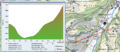
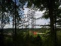
After I got out the train from university I hopped into my car (Which I use to drive home from the station). I earlier checked the hash on Google Earth and since I know the area I was sure to be able to park less than 400m (linear distance) away. On the maps it was easy to see that the hash is located next to or even below a HV-power line (the dotted line on the map). So I thought I'd simply follow the powerlines uphill until I hit the spot.
After I parked at the bottom of the valley, I figured that Google Maps doesn't feature level curves and Google Earth (and my memory) greatly underestimated the steppness (and usage) of that hill.
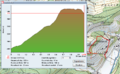
There were several fences and groves on my path and I was wearing streetwear and -shoes I decided to take a detour in favour of my clothes.
I consulted the maps on my phone and found a patch (the dashed line on the map) going quite close to the hash, so I started walking uphill and looked for the junction. I found it shortly thereafter, but it turned out to be private property and was fenced off and the home of some dogs.
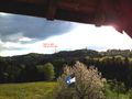
Again, I checked my phone for an alternative way and decided to go further uphill and then cross the small woods to get back in the open, above the spot. On my way I wished I did not wear a black shirt, because the sun was roasting me and I was really grateful to get in the shadow of the woods.
Crossing the woods was easier than expected, although the terrain was quite steep. The following descent to the hash was really pleasant and the hash itself was right at the edge of a grove, lying in its shadow. Unfortunately, the grove blocked the amazing view you'd have form up there, so there's only a picture for the uphill view. I did not stay at the hash for long because I had to go to my Dads birthday.
Photos
Beeline from home - piece of cake
... or isn't it?
Nearly seeing it from home
Close to the hash, seeing our house
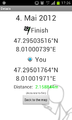
Hash reached!
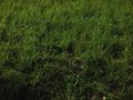
Spectacular hash site =)
- Error creating thumbnail: Unable to save thumbnail to destination
Smiling Foehammer, camera facing downhill
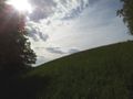
View uphill, glaring sun
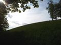
Another try, sun still glaring


Achievements
Foehammer earned the Land geohash achievement
|
