Difference between revisions of "2012-05-27 42 -72"
imported>Sara m (Oops again. My goodness.) |
imported>Sara (This was a great way to spend the afternoon.) |
||
| Line 1: | Line 1: | ||
| − | + | [[Image:{{{image|2012_05_27_42_-72_river.jpg.JPG}}}|thumb|left]] | |
| − | |||
| − | |||
| − | |||
| − | |||
| − | |||
| − | |||
| − | |||
{{meetup graticule | {{meetup graticule | ||
| lat=42 | | lat=42 | ||
| Line 14: | Line 7: | ||
}} | }} | ||
| − | |||
__NOTOC__ | __NOTOC__ | ||
== Location == | == Location == | ||
| − | + | In the trees near some houses in West Suffield, CT. | |
== Participants == | == Participants == | ||
| − | + | [[User:Sara|Sara]] | |
| − | |||
== Plans == | == Plans == | ||
| − | + | ||
| + | These days I'm especially interested in geohashes that I can do by bike or by foot. That means not only does the geohash have to be fairly close but, except for the very closest walking or biking hashes, the children have to be somewhere else. Today is a beautiful day with a fairly close hashpoint and the children are with the husband all day, which is just about perfect. | ||
| + | |||
| + | Because my bike has no baskets or other method of carrying stuff, instead of bringing my usual GPS and camera, I brought only a borrowed ipod, thinking I would use the Cheap GPS app. | ||
== Expedition == | == Expedition == | ||
| − | |||
| − | + | Interestingly, although I live in [[Springfield, Massachusetts|42, -72]] and the hashpoint is in [[Springfield, Massachusetts|42, -72]], the easiest bike route to the hash took me through [[Hartford, Connecticut|41,-72]]. This is because there's a big river between me and the hash and so one has to go south or north to get to a bridge. | |
| − | + | ||
| + | It started out great. As I was riding through Enfield, CT, the police closed the road to cars, but they let me continue on my bike. There were people standing along the road and I realized I was travelling on the parade route ahead of a Memorial Day parade. With all those people watching me I was glad I had take a few minutes to make myself semi-presentable before leaving the house. | ||
| + | |||
| + | I was glad to find a bike lane on the bridge over the Connecticut River between Enfield and Suffield. | ||
| + | |||
| + | I stopped on the Suffield town green to refill my water bottle from a water fountain and take some pictures (that didn't come out) of a Civil War monument. It was interesting to discover that monument on Memorial Day weekend. | ||
| + | |||
| + | A few minutes after I left the town green, around 13 km from home, the bike chain fell off one of the gears. I tried to reattach it, but I [[2009-08-07_42_-72|still]] didn't know how. I thought maybe I could find some instructions on the web, but the ipod couldn't reach the Internet. I had decided to start walking home with the bike and maybe try the Internet again after a few km when a nice guy came by on a bike and offered to help me. He put the chain back on the gear and explained to me how to do it for next time. | ||
| + | |||
| + | I continued to the street off of which the hash was located, but the ipod still couldn't get Internet access and so Cheap GPS wouldn't direct me to the hashpoint. I thought maybe if I typed in the hash coorinates it could direct me, but of course it couldn't - it needs the Internet to locate itself. | ||
| + | |||
| + | The ride home was just as fun as the ride to the hash. The Google Maps biking directions told me to get onto the Interstate. No thank you, not even just for the one exit you suggested. Luckily I was very near home at that point and didn't need the Google directions anymore. | ||
| − | == Photos == | + | == Photos == |
| − | |||
| − | |||
| − | |||
<gallery perrow="5"> | <gallery perrow="5"> | ||
| + | Image:2012_05_27 42 -72_trees.jpg.JPG | The hashpoint is probably somewhere in those trees, but I can't be sure because the "Cheap GPS" app wouldn't work. | ||
| + | Image:2012_05_27_42_-72_bike.jpg.JPG | This bike, which does not yet have a name, is much easier to ride than [[2009-11-03_41_-72|Marguerite]]. (Marguerite had a lot of character, but I didn't realize how messed up she was because she was my first bike.) | ||
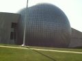
| + | Image:2012_05_27_42_-72_river.jpg.JPG | Crossing the Connecticut River on the way home. The Basketball Hall of Fame is visible in the background. | ||
| + | Image:2012_05_27_42_-72_horse.jpg.JPG | I was nearly home and wondering why I hadn't yet seen anything unexpected, and then I unexpectedly came to the fairgrounds and it turned out there was a horse show going on. Maybe the reason the horse is looking at the (ipod) camera is he wants to borrow it to play a game or check the Red Sox score? | ||
| + | Image:2012_05_27_42_-72_hall.jpg.JPG | And here's the Basketball Hall of Fame from close up. One of Springfield's only claims to fame is that basketball was invented here. | ||
</gallery> | </gallery> | ||
== Achievements == | == Achievements == | ||
{{#vardefine:ribbonwidth|800px}} | {{#vardefine:ribbonwidth|800px}} | ||
| − | + | {{Blinded by Science | |
| + | | latitude = 42 | ||
| + | | longitude = -72 | ||
| + | | date = 2012-05-27 | ||
| + | | reason = because it didn't occur to her that ipod GPS wouldn't work in a semi-rural area. | ||
| + | | name = Sara | ||
| + | }} | ||
| − | |||
| − | |||
| − | |||
| − | |||
| − | |||
| − | |||
| − | |||
| − | |||
| − | |||
| − | |||
[[Category:Expeditions]] | [[Category:Expeditions]] | ||
| − | |||
[[Category:Expeditions with photos]] | [[Category:Expeditions with photos]] | ||
| − | |||
| − | |||
| − | |||
| − | |||
| − | |||
| − | |||
| − | |||
| − | |||
| − | |||
[[Category:Coordinates not reached]] | [[Category:Coordinates not reached]] | ||
| − | + | [[Category:Not reached - Technology]] | |
| − | |||
| − | |||
| − | [[Category:Not reached - Technology]] | ||
| − | |||
| − | |||
Revision as of 22:48, 27 May 2012

| Sun 27 May 2012 in 42,-72: 42.0161098, -72.6978975 geohashing.info google osm bing/os kml crox |
Location
In the trees near some houses in West Suffield, CT.
Participants
Plans
These days I'm especially interested in geohashes that I can do by bike or by foot. That means not only does the geohash have to be fairly close but, except for the very closest walking or biking hashes, the children have to be somewhere else. Today is a beautiful day with a fairly close hashpoint and the children are with the husband all day, which is just about perfect.
Because my bike has no baskets or other method of carrying stuff, instead of bringing my usual GPS and camera, I brought only a borrowed ipod, thinking I would use the Cheap GPS app.
Expedition
Interestingly, although I live in 42, -72 and the hashpoint is in 42, -72, the easiest bike route to the hash took me through 41,-72. This is because there's a big river between me and the hash and so one has to go south or north to get to a bridge.
It started out great. As I was riding through Enfield, CT, the police closed the road to cars, but they let me continue on my bike. There were people standing along the road and I realized I was travelling on the parade route ahead of a Memorial Day parade. With all those people watching me I was glad I had take a few minutes to make myself semi-presentable before leaving the house.
I was glad to find a bike lane on the bridge over the Connecticut River between Enfield and Suffield.
I stopped on the Suffield town green to refill my water bottle from a water fountain and take some pictures (that didn't come out) of a Civil War monument. It was interesting to discover that monument on Memorial Day weekend.
A few minutes after I left the town green, around 13 km from home, the bike chain fell off one of the gears. I tried to reattach it, but I still didn't know how. I thought maybe I could find some instructions on the web, but the ipod couldn't reach the Internet. I had decided to start walking home with the bike and maybe try the Internet again after a few km when a nice guy came by on a bike and offered to help me. He put the chain back on the gear and explained to me how to do it for next time.
I continued to the street off of which the hash was located, but the ipod still couldn't get Internet access and so Cheap GPS wouldn't direct me to the hashpoint. I thought maybe if I typed in the hash coorinates it could direct me, but of course it couldn't - it needs the Internet to locate itself.
The ride home was just as fun as the ride to the hash. The Google Maps biking directions told me to get onto the Interstate. No thank you, not even just for the one exit you suggested. Luckily I was very near home at that point and didn't need the Google directions anymore.
Photos
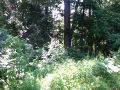
The hashpoint is probably somewhere in those trees, but I can't be sure because the "Cheap GPS" app wouldn't work.
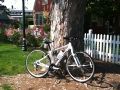
This bike, which does not yet have a name, is much easier to ride than Marguerite. (Marguerite had a lot of character, but I didn't realize how messed up she was because she was my first bike.)
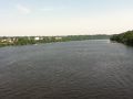
Crossing the Connecticut River on the way home. The Basketball Hall of Fame is visible in the background.
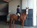
I was nearly home and wondering why I hadn't yet seen anything unexpected, and then I unexpectedly came to the fairgrounds and it turned out there was a horse show going on. Maybe the reason the horse is looking at the (ipod) camera is he wants to borrow it to play a game or check the Red Sox score?
And here's the Basketball Hall of Fame from close up. One of Springfield's only claims to fame is that basketball was invented here.


Achievements
Sara earned the Blinded by Science Consolation Prize
|