Difference between revisions of "2012-06-02 52 -121"
imported>Robyn (airhashing) |
m (More specific location) |
||
| (4 intermediate revisions by 3 users not shown) | |||
| Line 14: | Line 14: | ||
}} | }} | ||
| − | + | ||
__NOTOC__ | __NOTOC__ | ||
== Location == | == Location == | ||
| Line 20: | Line 20: | ||
== Participants == | == Participants == | ||
| − | *[[User:Robyn]] | + | *[[User:Robyn|Robyn]] |
* Spencer | * Spencer | ||
| Line 33: | Line 33: | ||
== Photos == | == Photos == | ||
| − | + | ||
| − | |||
| − | |||
| − | |||
<gallery perrow="5"> | <gallery perrow="5"> | ||
| + | File:2012-06-02 52 -121.point.jpg | Remember, this image is just a thumbnail. | ||
| + | File:2012-06-02 52 -121.clouds.jpg | These are the sorts of clouds we didn't want to be in mountains with. | ||
</gallery> | </gallery> | ||
| + | Compare and contrast with Google Maps: https://maps.google.com/?q=loc:52.430221839440186,-121.9486277887082&ll=52.431878,-121.948907&spn=0.006725,0.017424&t=h&z=16 | ||
| + | |||
| + | Ours has better colour. | ||
| + | |||
| + | == Achievements == | ||
| + | |||
| + | * Air Geohash | ||
[[Category:Expeditions]] | [[Category:Expeditions]] | ||
[[Category:Expeditions with photos]] | [[Category:Expeditions with photos]] | ||
| + | [[Category:Coordinates reached]] | ||
| + | {{location|CA|BC|CR}} | ||
Latest revision as of 23:55, 9 August 2020
| Sat 2 Jun 2012 in 52,-121: 52.4302218, -121.9486278 geohashing.info google osm bing/os kml crox |
Location
Pretty much exactly on our way from where the mountains and bad clouds ended to where we had to be next. That happened to put it near Inez Lake, not that we knew that at the time.
Participants
- Robyn
- Spencer
Plans
As documented in our previous expedition that day, our plans were just to get to Kamloops without flying into clouds, mountains or cloud-covered mountains, and to look for geohashes along the way.
Expedition
Spencer set up the line again and this time the line wasn't hundreds of kilometres long, so it worked the way it was supposed to, and took the photo automatically. I don't have any GPS set-up pictures and the photo isn't geotagged because it was just a thumbnail, but I think my main problem for any sceptics would not be in persuading you that the photo indeed represents the correct location, but that I didn't just cut and paste it from Google Maps. Ours doesn't have the copyright embedded on it, and the picture I have uploaded is actually just the thumbnail of the image we took.
Tracklog
Possibly available.
Photos
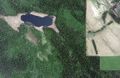
Remember, this image is just a thumbnail.
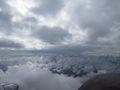
These are the sorts of clouds we didn't want to be in mountains with.


Compare and contrast with Google Maps: https://maps.google.com/?q=loc:52.430221839440186,-121.9486277887082&ll=52.431878,-121.948907&spn=0.006725,0.017424&t=h&z=16
Ours has better colour.
Achievements
- Air Geohash