Difference between revisions of "2012-06-22 52 1"
imported>Sourcerer ([live] Arrived.) |
imported>FippeBot m (Location) |
||
| (3 intermediate revisions by one other user not shown) | |||
| Line 1: | Line 1: | ||
| − | |||
| − | |||
| − | |||
| − | |||
| − | |||
| − | |||
| − | |||
| − | |||
| − | |||
| − | |||
{{meetup graticule | {{meetup graticule | ||
| − | | lat=52 | + | | lat=52 |
| − | | lon=1 | + | | lon=1 |
| − | | date=2012-06-22 | + | | date=2012-06-22 |
| + | | graticule_name=Norwich | ||
| + | | graticule_link=Norwich, United Kingdom | ||
}} | }} | ||
| − | |||
| − | |||
== Location == | == Location == | ||
| − | + | ||
| + | In Rendlesham Forest, Suffolk, UK. | ||
== Participants == | == Participants == | ||
| − | |||
| − | |||
| − | + | [[User:Sourcerer|Sourcerer]] | |
| − | |||
== Expedition == | == Expedition == | ||
| − | |||
| + | *Arrived. -- [[User:Sourcerer|Sourcerer]] [http://www.openstreetmap.org/?lat=52.0794118&lon=1.3971176&zoom=16&layers=B000FTF @52.0794,1.3971] 21:34, 22 June 2012 (GMT+01:00) | ||
| + | |||
| + | It was a 3.6 km circular walk from the parking place to the hashpoint and back. It was a cool evening after heavy rain. The wind was sighing in the treetops. The outward leg of the walk chased the setting sickle moon which was chasing the recently set sun. The whole walk was in Rendlesham Forest. This woodland has a mixture of pine cultivated for the timber and deciduous trees of many types. There are small paths everywhere and larger fire-break roads. It was a good place to go geohashing and celebrate the summer solstice (a day late). It was dusk at the start of the walk and quite dark at the hashpoint which was under a dense canopy of young closely planted pine trees. Luckily the undergrowth had been cleared so access was relatively easy. There were only 20 or 30 metres fighting through the young trees. On the return leg, an alligator was spotted lurking beside the path. A closer inspection revealed a carved tree trunk. | ||
| − | + | This area is famous for UFO sightings and there is a waymarked UFO trail. There are two military air bases in the immediate locality which might explain some the the sightings. There are also unusual phenomena with fog, low clouds and lighthouse beams. The coast is not far away. | |
| − | |||
| − | |||
== Photos == | == Photos == | ||
| − | < | + | |
| − | Image: | + | <gallery> |
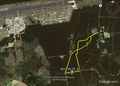
| − | -- | + | Image:2012-06-22 52 1 Sourcerer 1.jpg|Google Earth Tracklog |
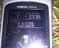
| − | + | Image:2012-06-22 52 1 Sourcerer 2.jpg|GPS Evidence | |
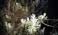
| + | Image:2012-06-22 52 1 Sourcerer 3.jpg|A Pine | ||
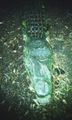
| + | Image:2012-06-22 52 1 Sourcerer 4.jpg|An Aligator (carved in wood) | ||
</gallery> | </gallery> | ||
== Achievements == | == Achievements == | ||
| − | |||
| − | |||
| + | {{gratuitous ribbon | ||
| + | | latitude = 52 | ||
| + | | longitude = 1 | ||
| + | | date = 2012-06-22 | ||
| + | | achievement = BambiHash | ||
| + | | description = by spotting two red deer quite close-up. | ||
| + | | name = Sourcerer | ||
| + | }} | ||
| − | + | {{Sourcerer_links | |
| − | + | | prev = 2012-06-19 52 1 | |
| − | + | | curr = 2012-06-22 52 1 | |
| + | | next = 2012-06-24 52 1 | ||
| + | | date = 2012-06-22 | ||
| + | }} | ||
| − | |||
| − | |||
| − | |||
| − | |||
| − | |||
| − | |||
[[Category:Expeditions]] | [[Category:Expeditions]] | ||
| − | |||
[[Category:Expeditions with photos]] | [[Category:Expeditions with photos]] | ||
| − | |||
| − | |||
| − | |||
| − | |||
| − | |||
[[Category:Coordinates reached]] | [[Category:Coordinates reached]] | ||
| − | + | {{location|GB|ENG|SFK}} | |
| − | |||
| − | |||
| − | |||
| − | |||
| − | |||
| − | |||
| − | |||
| − | |||
| − | |||
Latest revision as of 04:40, 13 August 2019
| Fri 22 Jun 2012 in Norwich: 52.0739489, 1.4241655 geohashing.info google osm bing/os kml crox |
Contents
Location
In Rendlesham Forest, Suffolk, UK.
Participants
Expedition
- Arrived. -- Sourcerer @52.0794,1.3971 21:34, 22 June 2012 (GMT+01:00)
It was a 3.6 km circular walk from the parking place to the hashpoint and back. It was a cool evening after heavy rain. The wind was sighing in the treetops. The outward leg of the walk chased the setting sickle moon which was chasing the recently set sun. The whole walk was in Rendlesham Forest. This woodland has a mixture of pine cultivated for the timber and deciduous trees of many types. There are small paths everywhere and larger fire-break roads. It was a good place to go geohashing and celebrate the summer solstice (a day late). It was dusk at the start of the walk and quite dark at the hashpoint which was under a dense canopy of young closely planted pine trees. Luckily the undergrowth had been cleared so access was relatively easy. There were only 20 or 30 metres fighting through the young trees. On the return leg, an alligator was spotted lurking beside the path. A closer inspection revealed a carved tree trunk.
This area is famous for UFO sightings and there is a waymarked UFO trail. There are two military air bases in the immediate locality which might explain some the the sightings. There are also unusual phenomena with fog, low clouds and lighthouse beams. The coast is not far away.
Photos
Google Earth Tracklog
GPS Evidence
A Pine
An Aligator (carved in wood)


Achievements
Sourcerer earned the BambiHash
|
Expeditions and Plans
| 2012-06-22 | ||
|---|---|---|
| Lafayette, Indiana | Ilinamorato, Piddiffle | Private home in Westfield, Indiana. |
| Sterling, Illinois | RocketMac | A cornfield in Toluca, Illinois. |
| Rockford, Illinois | RocketMac | A private farm in or near Scott Township, Illinois. |
| Eugene, Oregon | Michael5000 | Between Hayes & Garfield on 13th in Eugene. |
| München, Germany | Zertrin | The hash was located in the forest, about 30 meter from the road between Ne... |
| Frankfurt am Main, Germany | QuarterCacher, Mampfred | Behind a little barn in Hofheim. |
| Chełm, Poland | JRK | I had to wait for a whole month for the next easy hash in my area. The weat... |
| Norwich, United Kingdom | Sourcerer | In Rendlesham Forest, Suffolk, UK. |
Sourcerer's Expedition Links
2012-06-19 52 1 - 2012-06-22 52 1 - 2012-06-24 52 1 - KML file download of Sourcerer's expeditions for use with Google Earth.