Difference between revisions of "2012-06-30 52 4"
imported>Murfie (→Achievements) |
(→Achievements) |
||
| (11 intermediate revisions by 3 users not shown) | |||
| Line 27: | Line 27: | ||
== Palmpje's Plans == | == Palmpje's Plans == | ||
<!-- what were the original plans --> | <!-- what were the original plans --> | ||
| − | + | I decided this would be a good day for a first Geohash. It would mean having to drive about 15km to the haspoint and then another 5km before being able to turn back as this particular hashpoint is on a highway. Well, just a bit on the emergency strip but close enough to call it a success given the few meters of inaccuracy. It would have to be early in the day however so sadly little chance to meet other geohashers. | |
== Murfie's Plans == | == Murfie's Plans == | ||
| Line 37: | Line 37: | ||
<!-- how it all turned out. your narrative goes here. --> | <!-- how it all turned out. your narrative goes here. --> | ||
*Geohash success -- [[User:Palmpje|Palmpje]] | *Geohash success -- [[User:Palmpje|Palmpje]] | ||
| − | The hashpoint was reached | + | The hashpoint was reached around 9:05am, so much too early for a meetup which would be dangerous at the location anyway. I managed to get close enough to the hash by driving at the exact maximum allowed speed. Very tricky when you're alone in your car having to keep an eye on the GPS to determine your location relative to the hash _and_ observe trafic _and_ taking pictures without colliding with anything. |
| − | |||
| − | |||
| + | Given that I was able to enter this log, the Burgerveen Triangle appears to be a lot more benevolent than the Bermuda Triangle. | ||
== Murfie's Expedition == | == Murfie's Expedition == | ||
| Line 71: | Line 70: | ||
Image:2010-##-## ## ## Alpha.jpg | Witty Comment | Image:2010-##-## ## ## Alpha.jpg | Witty Comment | ||
--> | --> | ||
| + | * Murfie | ||
<gallery perrow="5"> | <gallery perrow="5"> | ||
Image:2012-06-30-52_4-ani2.gif | Animated gif of me driving like crazy... The server doesn't allow big files so I had to scale it like a stamp | Image:2012-06-30-52_4-ani2.gif | Animated gif of me driving like crazy... The server doesn't allow big files so I had to scale it like a stamp | ||
Image:2012-06-30-52_4-1.jpg | Trying the geohash again, but now with a slow car in front of me | Image:2012-06-30-52_4-1.jpg | Trying the geohash again, but now with a slow car in front of me | ||
| + | </gallery> | ||
| + | * Palmpje | ||
| + | <gallery perrow="5"> | ||
| + | Image:2012-06-30 Suggested.JPG | Dangerous curve ahead? | ||
| + | Image:2012-06-30 Close enough.JPG | It's here-ish | ||
| + | Image:2012-06-30 Speedometer.JPG | Exactly the maximum allowed. | ||
| + | Image:2012-06-30 Palmpje Silly Grin.JPG | Almost home, grin still there. | ||
</gallery> | </gallery> | ||
| Line 89: | Line 96: | ||
| speed = 120km/h | | speed = 120km/h | ||
}} | }} | ||
| + | |||
| + | {{Déjà vu geohash | ||
| + | |||
| + | | latitude = 52 | ||
| + | | longitude = 4 | ||
| + | | date = 2012-06-30 | ||
| + | | olddate = lots of other dates | ||
| + | | name = [[User:Murfie|Murfie]] | ||
| + | }} | ||
| + | Probably 99.9% people in this graticule have seen this geohash before, since it's on the main highway to Amsterdam... | ||
| + | |||
| + | {{land geohash | ||
| + | |||
| + | | latitude = 52 | ||
| + | | longitude = 4 | ||
| + | | date = 2012-06-30 | ||
| + | | name = Palmpje | ||
| + | }} | ||
| + | |||
| + | {{Speed racer | ||
| + | |||
| + | | latitude = 52 | ||
| + | | longitude = 4 | ||
| + | | date = 2012-06-30 | ||
| + | | name = [[User:Palmpje|Palmpje]] | ||
| + | | speed = 120km/h | ||
| + | }} | ||
| + | I never exceed the speed limit (uhm...) | ||
| + | |||
| + | {{Déjà vu geohash | ||
| + | |||
| + | | latitude = 52 | ||
| + | | longitude = 4 | ||
| + | | date = 2012-06-30 | ||
| + | | olddate = every workday from summer 1987 to summer 2004 and many times afterwards and inbetween | ||
| + | | name = [[User:Palmpje|Palmpje]] | ||
| + | }} | ||
| + | Yes, I've driven there many, many, many times. | ||
| + | |||
| + | {{Two to the N achievement | count = 0 | latitude = 52 | longitude = 4 | date = 2012-06-30 | name = Palmpje }} | ||
| + | {{Two to the N achievement | count = 0 | latitude = 52 | longitude = 4 | date = 2012-06-30 | reached = true | name = Palmpje }} | ||
[[Category:Expeditions]] | [[Category:Expeditions]] | ||
| Line 94: | Line 142: | ||
[[Category:Expeditions with videos]] | [[Category:Expeditions with videos]] | ||
[[Category:Coordinates reached]] | [[Category:Coordinates reached]] | ||
| + | {{location|NL|NH}} | ||
Latest revision as of 12:56, 5 March 2021
| Sat 30 Jun 2012 in 52,4: 52.2420946, 4.6615016 geohashing.info google osm bing/os kml crox |
Location
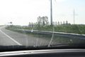
On the on-ramp from the A44 to A4 highway in the direction of Amsterdam, known as the Burgerveen triangle.
Participants
Palmpje's Plans
I decided this would be a good day for a first Geohash. It would mean having to drive about 15km to the haspoint and then another 5km before being able to turn back as this particular hashpoint is on a highway. Well, just a bit on the emergency strip but close enough to call it a success given the few meters of inaccuracy. It would have to be early in the day however so sadly little chance to meet other geohashers.
Murfie's Plans
Murfie was bragging on IRC he could easily earn a speed racer achievement on this one. He drives this road very often and therefore knows it really well. His plan was to go somewhere in the afternoon, and firmly push the accelerator.
Palmpje's Expedition
- Geohash success -- Palmpje
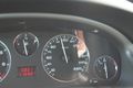
The hashpoint was reached around 9:05am, so much too early for a meetup which would be dangerous at the location anyway. I managed to get close enough to the hash by driving at the exact maximum allowed speed. Very tricky when you're alone in your car having to keep an eye on the GPS to determine your location relative to the hash _and_ observe trafic _and_ taking pictures without colliding with anything.
Given that I was able to enter this log, the Burgerveen Triangle appears to be a lot more benevolent than the Bermuda Triangle.
Murfie's Expedition
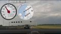
The plan was to go in the afternoon, but it got later and around evening time, I arrived at the Burgerveen Crossing. With some good traffic anticipation, I managed to be the first car in front of the traffic light for the road that gives access to the geohash. This way I figured was the best chance to avoid any slow cars in front of me. Since this geohash is on the A4-highway, the speed limit at the geohash location is 120km/h. Facts are that the geohash is (a bit on the shoulder road) on the entrace to the highway, and there's also some road maintenance going on there, so this won't be too easy. When the light went green, I made the turn to the entrance road and accelerated as fast as I could. It was a very close call but I reached 120km/h right in time!
I had mounted my Android phone on my dashboard to record some proof. Unfortunately, the acceleration caused that my dashboard cam turned into a cloud-cam for a while.
Then, I turned around at Hoofddorp. Took again the exit at Burgerveen and drove to Leimuiden to stop there. I searched for real dashboard app in the play store and installed it on my phone. Then I went to the geohash one more time, to record it with the dashboard cam app. However, from then on, things went horrible. First the bridge went up and I had to wait terribly long, and then I couldn't get a good spot at the traffic light to drive up the highway. The result was I could go only max 80 km/h this time because some slow cars in front of me. Oh well. The animated gif of the first trip should be enough proof anyway.
Tracklog
Photos
- Murfie

Animated gif of me driving like crazy... The server doesn't allow big files so I had to scale it like a stamp
Trying the geohash again, but now with a slow car in front of me


- Palmpje
Dangerous curve ahead?
It's here-ish
Exactly the maximum allowed.

Almost home, grin still there.


Achievements

Murfie earned the Déjà Vu Geohash Achievement
|
Probably 99.9% people in this graticule have seen this geohash before, since it's on the main highway to Amsterdam...
Palmpje earned the Land geohash achievement
|
I never exceed the speed limit (uhm...)
Palmpje earned the Déjà Vu Geohash Achievement
|
Yes, I've driven there many, many, many times.
