Difference between revisions of "2012-09-06 48 8"
imported>RecentlyChanged (→Achievements) |
m (Location correction) |
||
| (7 intermediate revisions by 3 users not shown) | |||
| Line 7: | Line 7: | ||
__NOTOC__ | __NOTOC__ | ||
== Location == | == Location == | ||
| − | On a field directly near the forest, with a quite nice | + | On a field directly near the forest, with a quite nice view. |
| + | |||
| + | Far enough from big streets not to hear them. | ||
== Participants == | == Participants == | ||
| Line 13: | Line 15: | ||
== Plans == | == Plans == | ||
| − | I was looking for an nice place to have a picnic with a girl. But | + | I was looking for an nice place to have a picnic with a girl. But I've had no real idea where to go, |
| − | So I asked here and she found it a funny idea. Luckily | + | so I have looked up the actual Hashpoint and it was not this far away, and near to an easy |
| − | Planned was: to have a picnic, use the | + | accessible street. |
| + | |||
| + | So I asked here and she found it a funny idea. Luckily I could rent me an GPS. | ||
| + | Planned was: to have a picnic, use the Slackline I would take with me and play Cards. | ||
== Expedition == | == Expedition == | ||
| − | I've picked her up with my Car and just wanted ride straight to the Hashpoint over the | + | I've picked her up with my Car and just wanted ride straight to the Hashpoint over the street |
| − | So we walked through the forest and need about 20 minutes to find it, what | + | I have seen on Google. But it turns out that Google haven't known about the roadworks. But because |
| + | I thought I know the area I've driven another way and ended not on top of the hill but in the | ||
| + | valley about half an mile crow to the hashpoint. | ||
| + | |||
| + | So we walked through the forest and need about 20 minutes to find it, what I find not this long. | ||
| − | At the Hashpoint their was an surprise. On a tree stump almost exactly at the Hashpoint was something red, it looked like a | + | At the Hashpoint their was an surprise. On a tree stump almost exactly at the Hashpoint was |
| + | something red, it looked like a piece of clay, washed down over time. I've never seen | ||
| + | something like this before ever and don't see any sense in it. If Geohashing where more | ||
| + | popular and it didn't look so washed down I have thought it is an marker. It was none but | ||
| + | I made one out of it and written in with a stick "Geohash 2012 9 6 DJ" (I don't know how long it will last) | ||
| − | After this we spread our blanket but no one of us was really hungry already. So we just drunk something and then we tighten up the Slackline and made what you normally make with a Slackline: (try to) walk back and forth. | + | After this we spread our blanket but no one of us was really hungry already. So we |
| + | just drunk something and then we tighten up the Slackline and made what you normally | ||
| + | make with a Slackline: (try to) walk back and forth. | ||
| − | After 3 hours of we walked back to my Car, we neither played cards or really made a picnic except a Donut for both of us, but I've learned to never push a girl to eat, so we don't eat and I carried all the stuff for nothing but my good will. | + | After 3 hours of we walked back to my Car, we neither played cards or really made a picnic |
| + | except a Donut for both of us, but I've learned to never push a girl to eat, so we don't eat | ||
| + | and I carried all the stuff for nothing but my good will. | ||
| − | All in all it was a really nice | + | All in all it was a really nice expedition, with good weather, a nice Hashpoint and really nice accompaniment :D |
| − | The only thing what annoys me is that of all my old digital camera stopped to work, so | + | The only thing what annoys me is that of all my old digital camera stopped to work, so |
| + | I have no more proof for my Expedition then the things you could see on my GPS device, sorry about that. | ||
== Tracklog == | == Tracklog == | ||
| − | Because my GPS Device is only rented i have no way to connect it to the PC, | + | Because my GPS Device is only rented i have no way to connect it to the PC, I'll try to show it to you in the Pictures but it isn't really awesome. |
| + | |||
| + | I tried do show our way from the car to the hash: http://goo.gl/maps/ZHIC4 | ||
| + | "A" is where we left the car an "B" is where we go off the street, the way back we made almost like this. "C" is near the Geohash. | ||
== Photos == | == Photos == | ||
| Line 38: | Line 59: | ||
<gallery perrow="3"> | <gallery perrow="3"> | ||
Image:Daten2012.9,6.JPG|The Tracklog as best as i can show You | Image:Daten2012.9,6.JPG|The Tracklog as best as i can show You | ||
| − | Image:wirklichDatenfirst.JPG|... and a few data about my | + | Image:wirklichDatenfirst.JPG|... and a few data about my traveling |
Image:AlterPhoto.JPG|Just for fun: the now useless Camera | Image:AlterPhoto.JPG|Just for fun: the now useless Camera | ||
| + | |||
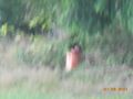
| + | Image:PreviousHash1-2012-09-07488.JPG | (Following Pictures are made on my next Expedition) The white tree stump with the red Ston | ||
| + | Image:PreviousHash2-2012-09-07488.JPG | and again with an exaggerated Zoom level (because of the hunter behind me) | ||
| + | Image:ViewPrevious2012-09-07488.JPG | The View we had at my first Geohash | ||
</gallery> | </gallery> | ||
| Line 47: | Line 72: | ||
| latitude = 48 | | latitude = 48 | ||
| longitude = 8 | | longitude = 8 | ||
| − | | date = 2012-09-06 | + | | date = 2012-09-06 |
| name = RecentlyChanged | | name = RecentlyChanged | ||
}} | }} | ||
{{Circus_geohash | {{Circus_geohash | ||
| latitude = 48 | | latitude = 48 | ||
| − | | longitude = | + | | longitude = 8 |
| − | | date = 2012-09-06 | + | | date = 2012-09-06 |
| name = RecentlyChanged | | name = RecentlyChanged | ||
| performance = walking across a Slackline | | performance = walking across a Slackline | ||
| Line 59: | Line 84: | ||
{{Picnic_geohash | {{Picnic_geohash | ||
| latitude = 48 | | latitude = 48 | ||
| − | | longitude = | + | | longitude = 8 |
| − | | date = 2012-09-06 | + | | date = 2012-09-06 |
| name = RecentlyChanged | | name = RecentlyChanged | ||
| food = Donuts | | food = Donuts | ||
| Line 67: | Line 92: | ||
| latitude = 48 | | latitude = 48 | ||
| longitude = 8 | | longitude = 8 | ||
| − | | date = 2012-09-06 | + | | date = 2012-09-06 |
| name = RecentlyChanged | | name = RecentlyChanged | ||
}} | }} | ||
| − | + | {{Two to the N achievement | |
| + | | count = 0 | ||
| + | | latitude = 48 | ||
| + | | longitude = 8 | ||
| + | | date = 2012-09-06 | ||
| + | | name = RecentlyChanged | ||
| + | | reached = true | ||
| + | }} | ||
[[Category:Expeditions]] | [[Category:Expeditions]] | ||
| + | [[Category:Expeditions with photos]] | ||
[[Category:Coordinates reached]] | [[Category:Coordinates reached]] | ||
| + | {{location|DE|BW|RW}} | ||
Latest revision as of 20:16, 16 May 2020
| Thu 6 Sep 2012 in 48,8: 48.1720749, 8.3103159 geohashing.info google osm bing/os kml crox |
Location
On a field directly near the forest, with a quite nice view.
Far enough from big streets not to hear them.
Participants
- RecentlyChanged and a female Date ;)
Plans
I was looking for an nice place to have a picnic with a girl. But I've had no real idea where to go, so I have looked up the actual Hashpoint and it was not this far away, and near to an easy accessible street.
So I asked here and she found it a funny idea. Luckily I could rent me an GPS. Planned was: to have a picnic, use the Slackline I would take with me and play Cards.
Expedition
I've picked her up with my Car and just wanted ride straight to the Hashpoint over the street I have seen on Google. But it turns out that Google haven't known about the roadworks. But because I thought I know the area I've driven another way and ended not on top of the hill but in the valley about half an mile crow to the hashpoint.
So we walked through the forest and need about 20 minutes to find it, what I find not this long.
At the Hashpoint their was an surprise. On a tree stump almost exactly at the Hashpoint was something red, it looked like a piece of clay, washed down over time. I've never seen something like this before ever and don't see any sense in it. If Geohashing where more popular and it didn't look so washed down I have thought it is an marker. It was none but I made one out of it and written in with a stick "Geohash 2012 9 6 DJ" (I don't know how long it will last)
After this we spread our blanket but no one of us was really hungry already. So we just drunk something and then we tighten up the Slackline and made what you normally make with a Slackline: (try to) walk back and forth.
After 3 hours of we walked back to my Car, we neither played cards or really made a picnic except a Donut for both of us, but I've learned to never push a girl to eat, so we don't eat and I carried all the stuff for nothing but my good will.
All in all it was a really nice expedition, with good weather, a nice Hashpoint and really nice accompaniment :D The only thing what annoys me is that of all my old digital camera stopped to work, so I have no more proof for my Expedition then the things you could see on my GPS device, sorry about that.
Tracklog
Because my GPS Device is only rented i have no way to connect it to the PC, I'll try to show it to you in the Pictures but it isn't really awesome.
I tried do show our way from the car to the hash: http://goo.gl/maps/ZHIC4 "A" is where we left the car an "B" is where we go off the street, the way back we made almost like this. "C" is near the Geohash.
Photos
I took them at home because the camera I have tried to use at the Hashpoint doesn't work
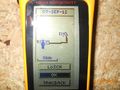
The Tracklog as best as i can show You
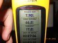
... and a few data about my traveling
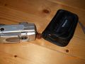
Just for fun: the now useless Camera
(Following Pictures are made on my next Expedition) The white tree stump with the red Ston
and again with an exaggerated Zoom level (because of the hunter behind me)
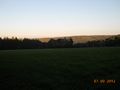
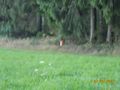
The View we had at my first Geohash


Achievements
RecentlyChanged earned the Land geohash achievement
|
RecentlyChanged earned the Circus Geohash Achievement
|
RecentlyChanged earned the Picnic achievement
|
RecentlyChanged earned the Drag-along achievement
|
