Difference between revisions of "2012-09-10 52 -0"
From Geohashing
imported>Benjw (success cats) |
imported>Benjw (photos and achievements) |
||
| Line 11: | Line 11: | ||
== Location == | == Location == | ||
| − | Lamb's Lane, a very minor road in Glatton village, | + | Lamb's Lane, a very minor road in Glatton village, next to a small airstrip. |
== Participants == | == Participants == | ||
| Line 27: | Line 27: | ||
== Photos == | == Photos == | ||
| − | |||
<gallery perrow="5"> | <gallery perrow="5"> | ||
| − | Image:2012- | + | Image:2012-09-10 52 -0 airfield sign.jpg | The airstrip was out of bounds, but the geohash was not on the airstrip. |
| + | Image:2012-09-10 52 -0 hashpoint.jpg | Ah yes, there it is. | ||
| + | Image:2012-09-10 52 -0 gps proof.jpg | Proof of hash. | ||
| + | Image:2012-09-10 52 -0 happy hashers.jpg | Two happy hashers hash happily. | ||
| + | Image:2012-09-10 52 -0 attempting photos.jpg | Photographing GPS screens is a skill. | ||
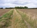
| + | Image:2012-09-10 52 -0 looking south.jpg | The view back down the track. | ||
| + | Image:2012-09-10 52 -0 planes.jpg | A small selection of planes next to the hashpoint. | ||
| + | Image:2012-09-10 52 -0 dr-spangle leaves.jpg | After chatting, we go our separate ways. | ||
</gallery> | </gallery> | ||
| − | |||
== Achievements == | == Achievements == | ||
{{#vardefine:ribbonwidth|800px}} | {{#vardefine:ribbonwidth|800px}} | ||
| − | + | {{land geohash | |
| + | | latitude = 52 | ||
| + | | longitude = -0 | ||
| + | | date = 2012-09-10 | ||
| + | | name = [[User:Dr-spangle|Dr-spangle]] and [[User:Benjw|Benjw]] | ||
| + | | image = 2012-09-10 52 -0 gps proof.jpg | ||
| + | }} | ||
| + | {{bicycle geohash | ||
| + | | latitude = 52 | ||
| + | | longitude = -0 | ||
| + | | date = 2012-09-10 | ||
| + | | name = [[User:Dr-spangle|Dr-spangle]] | ||
| + | | image = 2012-09-10 52 -0 dr-spangle leaves.jpg | ||
| + | }} | ||
| + | {{consecutive geohash | ||
| + | | count = 2 | ||
| + | | latitude = 52 | ||
| + | | longitude = 0 | ||
| + | | date = 2012-09-09 | ||
| + | | name = [[User:Benjw|Benjw]] | ||
| + | }} | ||
| + | {{meet-up | ||
| + | | latitude = 52 | ||
| + | | longitude = -0 | ||
| + | | date = 2012-09-10 | ||
| + | | name = [[User:Dr-spangle|Dr-spangle]] and [[User:Benjw|Benjw]] | ||
| + | | other = each other | ||
| + | | image = 2012-09-10 52 -0 happy hashers.jpg | ||
| + | }} | ||
| + | {{earliest geohasher | ||
| + | | latitude = 52 | ||
| + | | longitude = -0 | ||
| + | | date = 2012-09-10 | ||
| + | | name = [[User:Dr-spangle|Dr-spangle]] | ||
| + | }} | ||
[[Category:Expeditions]] | [[Category:Expeditions]] | ||
| − | + | [[Category:Expeditions with photos]] | |
[[Category:Coordinates reached]] | [[Category:Coordinates reached]] | ||
Revision as of 20:43, 10 September 2012
| Mon 10 Sep 2012 in Northampton, UK: 52.4656186, -0.3089016 geohashing.info google osm bing/os kml crox |
Location
Lamb's Lane, a very minor road in Glatton village, next to a small airstrip.
Participants
Plans
Planning took place on Dr-spangle's talk page. It was agreed that he would cycle from Oundle and Ben would drive from Cambridge. Both would aim to be at the hashpoint at around 2pm.
Expedition
Tracklog
Photos
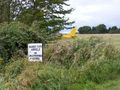
The airstrip was out of bounds, but the geohash was not on the airstrip.
Ah yes, there it is.
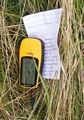
Proof of hash.
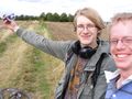
Two happy hashers hash happily.
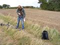
Photographing GPS screens is a skill.
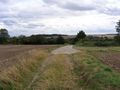
The view back down the track.
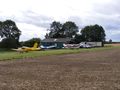
A small selection of planes next to the hashpoint.
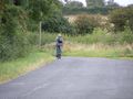
After chatting, we go our separate ways.


Achievements
Dr-spangle and Benjw earned the Land geohash achievement
|
Dr-spangle earned the Bicycle geohash achievement
|
Benjw earned the Consecutive geohash achievement
|
Dr-spangle and Benjw earned the Meet-up achievement
|
Dr-spangle earned the Earliest geohasher achievement
|