2012-09-14 52 1
From Geohashing
Revision as of 16:59, 14 September 2012 by imported>Jaydublu (Created page with "{{meetup graticule | lat=52 | lon=1 | date=2012-09-14 | graticule_name=Norwich | graticule_link=Norwich, United Kingdom }} == Location == In the shadow of East Rusto...")
| Fri 14 Sep 2012 in Norwich: 52.8149674, 1.5140635 geohashing.info google osm bing/os kml crox |
Contents
Location
In the shadow of East Ruston water tower, Norfolk, UK.
Participants
Expedition
Not a great hardship - this location was 100 yards from the turn around point when I take our dog for his daily walk. It was in the overgrown margin of a potatoe field, under East Ruston water tower near Happisburgh on the North Norfolk coast. The weather was 'autumnal' with a fresh breeze, and being one of the highest locations for many, many miles the view was wonderful.
Photos
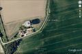
Google Earth View
- 2012-09-14 52 1 Jaydublu 2.jpg
East Ruston water tower

Other geohashing expeditions on the same day
Expeditions and Plans
| 2012-09-14 | ||
|---|---|---|
| Norwich, United Kingdom | Jaydublu, Sourcerer | In the shadow of East Ruston water tower, Norfolk, UK. |
| Malmö, Sweden | Llavids | Rolsberga, Höör, Skåne, Sweden. |
| Moscow, Russia | vb | Railway tracks between Krasniy Baltiets and Leningradskaya stations. |