Difference between revisions of "2012-11-05 49 8"
imported>RecentlyChanged (→Location) |
m |
||
| (20 intermediate revisions by 4 users not shown) | |||
| Line 1: | Line 1: | ||
| − | |||
<!-- If you did not specify these parameters in the template, please substitute appropriate values for IMAGE, LAT, LON, and DATE (YYYY-MM-DD format) | <!-- If you did not specify these parameters in the template, please substitute appropriate values for IMAGE, LAT, LON, and DATE (YYYY-MM-DD format) | ||
| Line 12: | Line 11: | ||
| lat=49 | | lat=49 | ||
| lon=8 | | lon=8 | ||
| − | | date=2012-11- | + | | date=2012-11-05 |
}} | }} | ||
| − | + | ||
__NOTOC__ | __NOTOC__ | ||
== Location == | == Location == | ||
| Line 21: | Line 20: | ||
== Participants == | == Participants == | ||
| − | + | * [[User:RecentlyChanged|RecentlyChanged]] and | |
| − | + | * [[User:Deuded|Deuded]] | |
== Plans == | == Plans == | ||
| − | + | After Lunch trying to reach the Coordinates. | |
| + | I can't guarantee to be there at 4pm because I have to be back earlier | ||
== Expedition == | == Expedition == | ||
| − | + | We planned to go geohashing (RecentlyChanged) and geocaching (Deuded), at first we want to visit the Hashpoint. | |
| + | |||
| + | We met in Karlsruhe and took bikes. We needed a little bit to find our way, but it wasn't a big detour. | ||
| + | At the time we started the weather looked quite better then the whole day, we saw the sky between the clouds. The growing black clouds to be more accurate, which exactly reached us (or we them) at the Hashpoint. It wasn't this bad because we could get the drowning rat Achievement, but we lost our bicycle geohash achievement. | ||
| + | |||
| + | |||
| + | The Hashpoint lies in the middle of a little field, between two trees. Almost perfectly at the Hash we found a golfball which RecentlyChanged took with him. | ||
| + | |||
| + | We walked to the next tram station and took the tram for our way back. | ||
== Tracklog == | == Tracklog == | ||
| − | + | http://www.everytrail.com/view_trip.php?trip_id=1870514&code=5b9b9c38172742ca5f9aa3767e647532 | |
== Photos == | == Photos == | ||
| − | |||
| − | |||
| − | |||
<gallery perrow="5"> | <gallery perrow="5"> | ||
| + | Image:2012-11-05 49 9 RC.JPG| First try of Proof | ||
| + | Image:2012-11-05 49 8 Proof1.JPG| Proof with RecentlyChanged... | ||
| + | Image:2012-11-05 49 8 Proof2.JPG| and with Deuded | ||
| + | Image:2012-11-05 49 9 Deuded.JPG| Another Photo of Deuded with the surrounding of the Geohash | ||
| + | Image:2012-11-05 49 9 Flash+rain.JPG| A Picture with Flash to proof the rain | ||
| + | Image:2012-11-05 49 8 damn im dirty.JPG| In the tram Recently realised that he need a mudguard | ||
| + | Image:2012-11-05 49 8 Bikes.JPG| Question: Which one took RecentlyChanged before? | ||
| + | Image:2012-11-05 49 8 Golfball.JPG| At least a photo of the golfball | ||
</gallery> | </gallery> | ||
== Achievements == | == Achievements == | ||
{{#vardefine:ribbonwidth|800px}} | {{#vardefine:ribbonwidth|800px}} | ||
| − | |||
| − | + | {{Land geohash | latitude = 49 | longitude = 8 | date = 2012-11-05 | name = RecentlyChanged and Deuded}} | |
| − | + | {{Public transport geohash | latitude = 49 | longitude = 8 | date = 2012-11-05 | busline = KVV | name = RecentlyChanged and Deuded }} | |
| − | + | {{Drowned rat geohash | latitude = 49 | longitude = 8 | date = 2012-11-05 | name = RecentlyChanged and Deuded | reason = significant rain and nowhere to hide | honourable = yes }} | |
| + | {{Bicycle geohash | latitude = 49 | longitude = 8 | date = 2012-11-05 | name = Deuded and RecentlyChanged }} | ||
| + | {{Geotrash | latitude = 49 | longitude = 8 | date = 2012-11-05 | name = Deuded and RecentlyChanged }} | ||
| + | |||
| + | {{Minesweeper geohash | graticule = Pforzheim, Germany | ranknumber = 1 | n = true | name = RecentlyChanged}} | ||
| + | {{drag-along | latitude = 49 | longitude = 8 | date = 2012-11-05| partner = [[User:Deuded|Deuded]] | name = RecentlyChanged}} | ||
| + | {{Two to the N achievement | ||
| + | | count = 2 | ||
| + | | latitude = 49 | ||
| + | | longitude = 8 | ||
| + | | date = 2012-11-05 | ||
| + | | name = RecentlyChanged | ||
| + | | reached = true | ||
| + | }} | ||
| + | |||
| + | |||
| − | |||
| − | |||
| − | |||
| − | |||
| − | |||
[[Category:Expeditions]] | [[Category:Expeditions]] | ||
| − | |||
[[Category:Expeditions with photos]] | [[Category:Expeditions with photos]] | ||
| − | |||
| − | |||
| − | |||
| − | |||
| − | |||
[[Category:Coordinates reached]] | [[Category:Coordinates reached]] | ||
| − | + | {{location|DE|BW|KA|city=true}} | |
| − | |||
| − | |||
| − | |||
| − | |||
| − | |||
| − | |||
| − | |||
| − | |||
| − | |||
| − | |||
| − | |||
| − | |||
| − | |||
| − | |||
| − | |||
| − | |||
| − | |||
Latest revision as of 16:55, 26 March 2020
| Mon 5 Nov 2012 in 49,8: 49.0400338, 8.3610156 geohashing.info google osm bing/os kml crox |
Location
Not to far away from the University I hope.
Participants
Plans
After Lunch trying to reach the Coordinates. I can't guarantee to be there at 4pm because I have to be back earlier
Expedition
We planned to go geohashing (RecentlyChanged) and geocaching (Deuded), at first we want to visit the Hashpoint.
We met in Karlsruhe and took bikes. We needed a little bit to find our way, but it wasn't a big detour. At the time we started the weather looked quite better then the whole day, we saw the sky between the clouds. The growing black clouds to be more accurate, which exactly reached us (or we them) at the Hashpoint. It wasn't this bad because we could get the drowning rat Achievement, but we lost our bicycle geohash achievement.
The Hashpoint lies in the middle of a little field, between two trees. Almost perfectly at the Hash we found a golfball which RecentlyChanged took with him.
We walked to the next tram station and took the tram for our way back.
Tracklog
http://www.everytrail.com/view_trip.php?trip_id=1870514&code=5b9b9c38172742ca5f9aa3767e647532
Photos
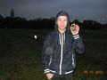
First try of Proof
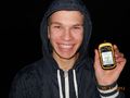
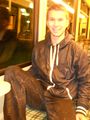
Proof with RecentlyChanged...
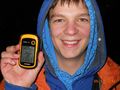
and with Deuded
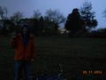
Another Photo of Deuded with the surrounding of the Geohash
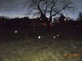
A Picture with Flash to proof the rain
In the tram Recently realised that he need a mudguard
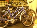
Question: Which one took RecentlyChanged before?
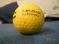
At least a photo of the golfball


Achievements
RecentlyChanged and Deuded earned the Land geohash achievement
|
RecentlyChanged and Deuded earned the Public transport geohash achievement
|
RecentlyChanged and Deuded earned the Drowned Rat Geohash Honourable Mention
|
Deuded and RecentlyChanged earned the Bicycle geohash achievement
|
Deuded and RecentlyChanged earned the GeoTrash Geohash Achievement
|
RecentlyChanged achieved level 1 of the Minesweeper Geohash achievement
|
RecentlyChanged earned the Drag-along achievement
|

- Meetup on 2012-11-05
- Meetup in 49 8
- Land geohash achievement
- Public transport geohash achievement
- Drowned rat geohash achievement
- Bicycle geohash achievement
- Geotrash achievement
- Minesweeper geohash achievement
- Drag-along achievement
- Two to the N achievement
- Expeditions
- Expeditions with photos
- Coordinates reached
- Meetup in Karlsruhe