Difference between revisions of "2012-12-10 60 22"
imported>Suurnesu ([live picture] [http://www.openstreetmap.org/?lat=60.43410000&lon=22.30860000&zoom=16&layers=B000FTF @60.4341,22.3086]) |
imported>Suurnesu |
||
| Line 1: | Line 1: | ||
| − | |||
| − | |||
| − | |||
| − | |||
| − | |||
| − | |||
| − | |||
| − | |||
| − | |||
| − | |||
{{meetup graticule | {{meetup graticule | ||
| lat=60 | | lat=60 | ||
| Line 19: | Line 9: | ||
== Location == | == Location == | ||
<!-- where you've surveyed the hash to be --> | <!-- where you've surveyed the hash to be --> | ||
| + | Today's location dropped very conveniently in the middle of Turku's largest graveyard. | ||
== Participants == | == Participants == | ||
<!-- who attended: If you link to your wiki user name in this section, your expedition will be picked up by the various statistics generated for geohashing. You may use three tildes ~ as a shortcut to automatically insert the user signature of the account you are editing with. | <!-- who attended: If you link to your wiki user name in this section, your expedition will be picked up by the various statistics generated for geohashing. You may use three tildes ~ as a shortcut to automatically insert the user signature of the account you are editing with. | ||
--> | --> | ||
| + | [[User:Suurnesu]] | ||
== Plans == | == Plans == | ||
| Line 31: | Line 23: | ||
| − | + | Today's hash point was very conveniently close to my home and within a walking distance. It was quite cold, -6 degC but it wasn't at all windy. I noticed that some interesting achievements could be obtained today so I didn't hesitate but took my flashlight and went to the cemetery. | |
| + | |||
| + | All the lights at the cemetery are turned off at 21, so the whole place was dark. Only light came from some candles at graves, and my flashlight which I occasionally had to use. It was very nice and somewhat spooky to walk around the graveyard at night. I decided to go after [[Tron achievement]] and I took a little detour just in case. Close to the zero point, I had to do additional lap in order to avoid stepping on someone's grave. Hash point was easily reached and I celebrated by making a small snowman at the location and tried to take some pictures. Phone's camera wasn't very good in the darkness. | ||
| + | |||
| + | I took another route towards home. I walked through the oldest part of the graveyard. There are the most scary monuments and there are a lot of ghosts too. I didn't meet anyone, though. maybe it was too cold for the ghosts, dunno... | ||
| + | |||
| + | There were some paths missin at the OpenStreetMap so I draw them at the same time | ||
| + | |||
| + | -- [[User:Suurnesu|suurnesu]] [http://www.openstreetmap.org/?lat=60.43410726&lon=22.30869572&zoom=16&layers=B000FTF @60.4341,22.3087] 14:32, 10 December 2012 (EST) | ||
== Tracklog == | == Tracklog == | ||
<!-- if your GPS device keeps a log, you may post a link here --> | <!-- if your GPS device keeps a log, you may post a link here --> | ||
| Line 41: | Line 41: | ||
<gallery perrow="5"> | <gallery perrow="5"> | ||
| − | Image:2012-12-10_60_22_21-36-50-504.jpg | | + | Image:2012-12-10_60_22_21-36-50-504.jpg | Extremely scared geohasher in the middle of graveyard |
Image:2012-12-10_60_22_21-42-42-810.jpg | [http://www.openstreetmap.org/?lat=60.43410000&lon=22.30860000&zoom=16&layers=B000FTF @60.4341,22.3086] | Image:2012-12-10_60_22_21-42-42-810.jpg | [http://www.openstreetmap.org/?lat=60.43410000&lon=22.30860000&zoom=16&layers=B000FTF @60.4341,22.3086] | ||
| + | |||
| + | Image:2012-12-10-60-22-map.jpg | My track | ||
| + | |||
| + | Image:2012-12-10-60-22-trash.jpg | Picking up trash on the way | ||
| + | |||
| + | Image:2012-12-10-60-22-gate.jpg | Graveyard gate | ||
| + | |||
| + | Image:2012-12-10-60-22-graves.jpg | Old graves | ||
| + | |||
| + | Image:2012-12-10-60-22-zero.jpg | At zero point | ||
| + | |||
| + | Image:2012-12-10-60-22-temp.png | Temperature was -6 decC | ||
| + | |||
</gallery> | </gallery> | ||
| Line 49: | Line 62: | ||
{{#vardefine:ribbonwidth|800px}} | {{#vardefine:ribbonwidth|800px}} | ||
<!-- Add any achievement ribbons you earned below, or remove this section --> | <!-- Add any achievement ribbons you earned below, or remove this section --> | ||
| + | |||
| + | {{Tron | ||
| + | | latitude = 60 | ||
| + | | longitude = 22 | ||
| + | | date = 2012-12-10 | ||
| + | | name = [[User:Suurnesu|Suurnesu]] | ||
| + | | tracklog = http://www.gpsvisualizer.com/display/1355214296-17936-130.232.105.160.html | ||
| + | | possessive = his | ||
| + | }} | ||
| + | |||
| + | {{holy hash | ||
| + | | latitude = 60 | ||
| + | | longitude = 22 | ||
| + | | date = 2012-12-10 | ||
| + | | name = [[User:Suurnesu|Suurnesu]] | ||
| + | | description = At the largest graveyard in Turku | ||
| + | }} | ||
| + | |||
| + | {{Walk geohash | ||
| + | | latitude = 60 | ||
| + | | longitude = 22 | ||
| + | | date = 2012-12-10 | ||
| + | | name = [[User:Suurnesu|Suurnesu]] | ||
| + | }} | ||
| + | |||
| + | {{Geotrash | ||
| + | | latitude = 60 | ||
| + | | longitude = 22 | ||
| + | | date = 2012-12-10 | ||
| + | | name = [[User:Suurnesu]] | ||
| + | }} | ||
| + | |||
| + | {{snowman geohash | ||
| + | | latitude = 60 | ||
| + | | longitude = 22 | ||
| + | | date = 2012-12-10 | ||
| + | | name = [[User:Suurnesu]] | ||
| + | }} | ||
| + | |||
| + | {{Frozen Geohash | ||
| + | | latitude = 60 | ||
| + | | longitude = 22 | ||
| + | | date = 2012-12-10 | ||
| + | | temperature = -6°C | ||
| + | | name = [[User:Suurnesu]] | ||
| + | }} | ||
| + | |||
| + | {{OpenStreetMap achievement | ||
| + | | latitude = 60 | ||
| + | | longitude = 22 | ||
| + | | date = 2012-12-10 | ||
| + | | name = [[User:Suurnesu]] | ||
| + | | OSMlink = 14236025 | ||
| + | }} | ||
| + | |||
| Line 60: | Line 128: | ||
--> | --> | ||
| − | + | ||
[[Category:Expeditions]] | [[Category:Expeditions]] | ||
| − | + | ||
[[Category:Expeditions with photos]] | [[Category:Expeditions with photos]] | ||
| − | + | ||
| − | |||
| − | |||
| − | |||
| − | |||
[[Category:Coordinates reached]] | [[Category:Coordinates reached]] | ||
| − | + | <!-- or if you failed :( | |
| − | |||
[[Category:Coordinates not reached]] | [[Category:Coordinates not reached]] | ||
-- and a reason -- | -- and a reason -- | ||
Revision as of 09:37, 11 December 2012
| Mon 10 Dec 2012 in 60,22: 60.4341147, 22.3086250 geohashing.info google osm bing/os kml crox |
Location
Today's location dropped very conveniently in the middle of Turku's largest graveyard.
Participants
Plans
Expedition
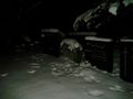
Today's hash point was very conveniently close to my home and within a walking distance. It was quite cold, -6 degC but it wasn't at all windy. I noticed that some interesting achievements could be obtained today so I didn't hesitate but took my flashlight and went to the cemetery.
All the lights at the cemetery are turned off at 21, so the whole place was dark. Only light came from some candles at graves, and my flashlight which I occasionally had to use. It was very nice and somewhat spooky to walk around the graveyard at night. I decided to go after Tron achievement and I took a little detour just in case. Close to the zero point, I had to do additional lap in order to avoid stepping on someone's grave. Hash point was easily reached and I celebrated by making a small snowman at the location and tried to take some pictures. Phone's camera wasn't very good in the darkness.
I took another route towards home. I walked through the oldest part of the graveyard. There are the most scary monuments and there are a lot of ghosts too. I didn't meet anyone, though. maybe it was too cold for the ghosts, dunno...
There were some paths missin at the OpenStreetMap so I draw them at the same time
-- suurnesu @60.4341,22.3087 14:32, 10 December 2012 (EST)
Tracklog
Photos

Extremely scared geohasher in the middle of graveyard
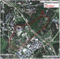
My track
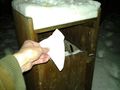
Picking up trash on the way
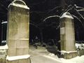
Graveyard gate
Old graves
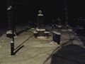
At zero point
Temperature was -6 decC


Achievements
Suurnesu earned the Tron achievement
|
Suurnesu earned the Holy hash achievement
|
Suurnesu earned the Walk geohash Achievement
|
User:Suurnesu earned the GeoTrash Geohash Achievement
|
User:Suurnesu earned the Snowman Geohash Achievement
|

User:Suurnesu earned the OpenStreetMap achievement
|