Difference between revisions of "2013-05-26 37 -121"
imported>Ted m (added self (TEd)) |
imported>FippeBot m (Location) |
||
| (18 intermediate revisions by 4 users not shown) | |||
| Line 18: | Line 18: | ||
__NOTOC__ | __NOTOC__ | ||
== Location == | == Location == | ||
| − | |||
| − | + | Sunday: | |
| − | + | ||
| + | SJ: Wow. About 1/4 mile from my house, near the Redwood Lodge! (Santa Cruz County, off 17.) I do believe I'll walk the dogs down there! :) I may even take George to celebrate, too. :) ~Ted | ||
== Participants == | == Participants == | ||
| − | |||
| − | |||
| + | * [[user:Anniepoo|Anniepoo]] | ||
| + | * [[user:Ted|Ted]] (with Vicki, Rose & Roxanne as drag-alongs. Possibly neighbor-Greg. :) | ||
| − | + | == Plans == | |
| − | |||
| − | |||
| − | + | We could officially declare that mouseover day is sunday this year for the SJ graticule. | |
| − | + | I'd come down and help walk the dogs. ~Anniepoo | |
| − | |||
| − | |||
Well, Mouseover Day (Observed) is Saturday (Actual was last Tuesday), but there's no reason we can't celebrate on Sunday. (Same as how not everyone has their Memorial BBQs on Monday! :) | Well, Mouseover Day (Observed) is Saturday (Actual was last Tuesday), but there's no reason we can't celebrate on Sunday. (Same as how not everyone has their Memorial BBQs on Monday! :) | ||
| − | See the confluence of Laurel Rd., Schulties Rd & Redwood Lodge Rd., just | + | See the confluence of Laurel Rd., Schulties Rd & Redwood Lodge Rd., just West of the spot? That's a decent place to meet (also a fair bit of parking and a nice walk to the spot.) |
NOTE: by "nice walk", I mean you go down a steep-ish hill then part way back up. I'm by no means a fast-mover but, if you heave health issues, you might want to meet us closer to The Spot. | NOTE: by "nice walk", I mean you go down a steep-ish hill then part way back up. I'm by no means a fast-mover but, if you heave health issues, you might want to meet us closer to The Spot. | ||
| − | But if folks wanted to pick a time (3:30pm ish?) to meet at the intersection described above ("at the mailboxes") and walk down with our pups, that'd be great. Basically, that's what I'll be doing, anyway, so as many of you as want to can join us. :) | + | But if folks wanted to pick a time (3:30pm ish?) to meet at the intersection described above ("at the mailboxes") and walk down with our pups, that'd be great. Basically, that's what I'll be doing, anyway, so as many of you as want to can join us. :) ~Ted |
| + | |||
| + | '''Noonish-of edit:''' | ||
| + | I'll be at the intersection described above at 3:30, lord willin' and the creek don't rise | ||
| + | [[User:Anniepoo|Anniepoo]] ([[User talk:Anniepoo|talk]]) 14:55, 26 May 2013 (EDT) | ||
| + | |||
| + | '''Morning-of edit:''' | ||
| + | I originally thought that the creek might offer us the [[water_geohash|water achievement]] but, reading the qualifications, I don't think it's deep enough. Then I thought we might have a potential [[Drowned_Rat_Geohash|drowned rat achievement]], but you'd have to work pretty hard to get that wet, and folks might claim you were faking it. We were almost assured of getting the [[Walking_on_water_geohash_achievement |walking on water achievement]], but that is defined as requiring water deep enough for a basic water achievement. I can understand the originator's wanting to exclude a wet sidewalk, but I'll have to enquire about an actual visibly-flowing creek. [[User:Ted|Ted]] ([[User talk:Ted|talk]]) 15:36, 26 May 2013 (EDT) | ||
== Expedition == | == Expedition == | ||
| − | + | ||
| + | Turns out Ted & Vicki live waaaaay the heck off in the backwoods - especially | ||
| + | if you come in from the wrong direction, as I did. | ||
| + | |||
| + | I nursed my aged RV up 17 to Summit Road, and then spent an hour or so crawling | ||
| + | along increasingly scary country roads amongst increasingly | ||
| + | scary big trees. The engine's making scary smells. | ||
| + | |||
| + | Predictably, there had to be equipment problems - my phone charger was getting 'pernickety' | ||
| + | about plugging in - I had both hands firmly on the wheel, and definitely couldn't | ||
| + | fiddle with it. | ||
| + | |||
| + | My GPS nav yells at me that I've 'reached my destination', but only because it wisely | ||
| + | doesn't advise me to plunge the RV into the ravine. There's no stopping place. The overworked brakes wouldn't have stopped me at that point anyway. | ||
| + | |||
| + | I finally pull up at what I've established is the creek that probably contains the hash. | ||
| + | There's a driveway down to a retreat center. | ||
| + | Two guys are working on something concrete at the bottom. I call down to them and establish | ||
| + | that the '3 way intersection' is ahead a half mile, and there's a stop sign so I'll know I've | ||
| + | reached it. | ||
| + | |||
| + | Since I've already accepted that the RV's going to be a total write-off, that I'll never get | ||
| + | it out of here, I inch it forward and up a steep hill, and yup, there, standing in the | ||
| + | road, are a friendly looking couple and their less friendly looking dogs. | ||
| + | |||
| + | Ted, for it is indeed Ted and Vicki, waves me into a parking spot. I soon establish that | ||
| + | the dogs, Roxanne and Rose, are much friendlier than they first appear, and soon we're all | ||
| + | having a great time. | ||
| + | |||
| + | Turns out that the route back to the hash is down the steep hill road I've just driven up, | ||
| + | so we set off back down the hill to the retreat center. | ||
| + | |||
| + | Ted's taken the precaution of sending an email to Bob the owner, asking for the name of the owner | ||
| + | of the land next to Bob's, so we can get permission. What we didn't count on was Bob's reluctance to let the dogs on the property. But Ted takes the lead, pleads that the internet directs us, and Bob relents. We can bring the dogs. | ||
| + | |||
| + | On the other hand, explains Bob, There's a dam with a 14 ft sheer drop back there. We decide to walk back and check it out, and yup, he's right, there's a damn dam there. Reluctant to do crazy things involving walking back up the hill to get climbing gear, we give in gracefully, a scant 50 ft or so from the hash. | ||
| + | |||
| + | Ted gets pics of Vicki and I on the dam, and we decide it's best not to strain Bob's hospitality. | ||
| + | On the way out we discover there's a set of stone steps from the 'you have arrived at your destination' point to the last point we reached... Oh, well. | ||
| + | |||
| + | I'm no batteries due to a) no cell coverage, so I wouldn't have map anyway, and b) no batteries, so we're depending on Ted's phone, which is marginal as well. | ||
| + | |||
| + | We work our way back to the RV slowly, with a couple pit stops for the fat chick (me) and a couple more for the dogs. I discover that the 3 way intersection is at one end of an old railroad tunnel, which is vastly fun. | ||
| + | |||
| + | Bob and Vicki point out that of course I came in by the hard way, and point out an ostensibly easier way out. I take it. It gets me back to 17. I drive back to San Jose. | ||
| + | |||
| + | I didn't see a 7-11 within 1km of the hash. In fact, I don't see anything commercial til I getback to the Summit Store near 17. | ||
| + | |||
| + | [[User:Anniepoo|Anniepoo]] ([[User talk:Anniepoo|talk]]) 23:02, 26 May 2013 (EDT) | ||
| + | |||
| + | |||
| + | While we may or may not have been directly over the exact-correct spot, (a) GPS coverage is spotty back there (too much tree cover), (b) our printed-maps made it look as if we were pretty much right there and (c) even if we ''were'' 50' off (I'm not admitting to this! ;), I think that's within one decimal place of the coordinates we were given. | ||
| + | |||
| + | Given all of that, I'm calling it a success. That, and nobody died, which is always the first sign of a successful hash! :) [[User:Ted|Ted]] ([[User talk:Ted|talk]]) 12:36, 27 May 2013 (EDT) | ||
== Tracklog == | == Tracklog == | ||
| Line 57: | Line 113: | ||
--> | --> | ||
<gallery perrow="5"> | <gallery perrow="5"> | ||
| + | Image: 2013-05-26 37 -121-a.jpg | The approach. [[User:Ted|User:Ted]], [[User:Anniepoo|Anniepoo]], Vicki and Rose (out of frame: Roxanne.) | ||
| + | Image: 2013-05-26 37 -121-b.jpg | Vicki and [[User:Anniepoo|Anniepoo]] at the spot. | ||
| + | Image: 2013-05-26 37 -121-c.jpg | Another view of the spot. | ||
</gallery> | </gallery> | ||
| Line 65: | Line 124: | ||
This is going to be our officially redeclared mouseover day!! | This is going to be our officially redeclared mouseover day!! | ||
| − | + | If anyone wants to shoot for it, this will be an easy no-batteries hash. Also, GoogleMaps shows the creek further West, but I believe it may be VERY close to the spot, in which case also a water-hash. | |
| + | |||
| + | I'll let her decide if she wants to take it, but I'd definitely back Anniepoo for an Extreme Dedication hash! | ||
| + | |||
| + | Truly sad that we didn't reach the hash. Otherwise everybody but Annie would have gotten Couch Potato Geohash Honorable Mention. | ||
| + | |||
| + | {{Cliffs of Despair | ||
| + | | latitude = 37 | ||
| + | | longitude = -121 | ||
| + | | date = 2013-05-26 | ||
| + | | name = [[User:Ted|Ted]], [[User:Anniepoo|Anniepoo]], [[User:Vicki|Vicki]], Rose, Roxanne | ||
| + | | terrain = Dam face | ||
| + | | image = 2013-05-26_37_-121-b.jpg | ||
| + | }} | ||
| + | |||
| + | Rose & Roxanne would have qualified for Restricted Area if we'd made it. | ||
| + | |||
| + | Ted wins Radio Yerevan on the OpenStreetMap achievement, as he convinced Google to | ||
| + | change the location of the road so it wasn't in the midst of the creek. | ||
| + | |||
| + | Vicki says she's been to that spot before, but had no proof. | ||
| − | [[ | + | And of course Ted did a masterful job getting us in with the dogs. (Nope, reaching the |
| + | point's not required - just permission to get to the point) | ||
| + | |||
| + | {{Ambassador geohash | ||
| + | | latitude = 37 | ||
| + | | longitude = -121 | ||
| + | | date = 2013-05-26 | ||
| + | | granter = Bob | ||
| + | | name = [[User:Ted|Ted]] | ||
| + | | image = 2013-05-26_37_-121-a.jpg | ||
| + | }} | ||
| + | |||
| + | And since we, by the magic of consensus thinking, had moved #towelday to Sunday, | ||
| + | all get | ||
| + | |||
| + | {{Geohashing Day | ||
| + | | latitude = 37 | ||
| + | | longitude = -121 | ||
| + | | year = 2013 | ||
| + | | coorddate= 2013-05-26 | ||
| + | | mouseover = true | ||
| + | | name = [[User:Ted|Ted]], [[User:Anniepoo|Anniepoo]], [[User:Vicki|Vicki]], Rose, Roxanne | ||
| + | | celebration = damning a dam! | ||
| + | }} | ||
| − | |||
[[Category:Expeditions]] | [[Category:Expeditions]] | ||
| − | + | ||
[[Category:Expeditions with photos]] | [[Category:Expeditions with photos]] | ||
| − | + | ||
[[Category:Expedition without GPS]] | [[Category:Expedition without GPS]] | ||
| − | |||
| − | |||
| − | |||
| − | |||
| − | |||
| − | |||
[[Category:Coordinates not reached]] | [[Category:Coordinates not reached]] | ||
| − | |||
| − | |||
| − | |||
| − | |||
| − | |||
| − | |||
| − | |||
| − | |||
| − | |||
| − | |||
| − | |||
| − | + | [[Category:Not reached - Mother Nature]] | |
| + | {{location|US|CA|SZ}} | ||
Latest revision as of 02:34, 14 August 2019
| Sun 26 May 2013 in 37,-121: 37.1145906, -121.9600620 geohashing.info google osm bing/os kml crox |
Location
Sunday:
SJ: Wow. About 1/4 mile from my house, near the Redwood Lodge! (Santa Cruz County, off 17.) I do believe I'll walk the dogs down there! :) I may even take George to celebrate, too. :) ~Ted
Participants
Plans
We could officially declare that mouseover day is sunday this year for the SJ graticule. I'd come down and help walk the dogs. ~Anniepoo
Well, Mouseover Day (Observed) is Saturday (Actual was last Tuesday), but there's no reason we can't celebrate on Sunday. (Same as how not everyone has their Memorial BBQs on Monday! :)
See the confluence of Laurel Rd., Schulties Rd & Redwood Lodge Rd., just West of the spot? That's a decent place to meet (also a fair bit of parking and a nice walk to the spot.)
NOTE: by "nice walk", I mean you go down a steep-ish hill then part way back up. I'm by no means a fast-mover but, if you heave health issues, you might want to meet us closer to The Spot.
But if folks wanted to pick a time (3:30pm ish?) to meet at the intersection described above ("at the mailboxes") and walk down with our pups, that'd be great. Basically, that's what I'll be doing, anyway, so as many of you as want to can join us. :) ~Ted
Noonish-of edit: I'll be at the intersection described above at 3:30, lord willin' and the creek don't rise Anniepoo (talk) 14:55, 26 May 2013 (EDT)
Morning-of edit: I originally thought that the creek might offer us the water achievement but, reading the qualifications, I don't think it's deep enough. Then I thought we might have a potential drowned rat achievement, but you'd have to work pretty hard to get that wet, and folks might claim you were faking it. We were almost assured of getting the walking on water achievement, but that is defined as requiring water deep enough for a basic water achievement. I can understand the originator's wanting to exclude a wet sidewalk, but I'll have to enquire about an actual visibly-flowing creek. Ted (talk) 15:36, 26 May 2013 (EDT)
Expedition
Turns out Ted & Vicki live waaaaay the heck off in the backwoods - especially if you come in from the wrong direction, as I did.
I nursed my aged RV up 17 to Summit Road, and then spent an hour or so crawling along increasingly scary country roads amongst increasingly scary big trees. The engine's making scary smells.
Predictably, there had to be equipment problems - my phone charger was getting 'pernickety' about plugging in - I had both hands firmly on the wheel, and definitely couldn't fiddle with it.
My GPS nav yells at me that I've 'reached my destination', but only because it wisely doesn't advise me to plunge the RV into the ravine. There's no stopping place. The overworked brakes wouldn't have stopped me at that point anyway.
I finally pull up at what I've established is the creek that probably contains the hash. There's a driveway down to a retreat center. Two guys are working on something concrete at the bottom. I call down to them and establish that the '3 way intersection' is ahead a half mile, and there's a stop sign so I'll know I've reached it.
Since I've already accepted that the RV's going to be a total write-off, that I'll never get it out of here, I inch it forward and up a steep hill, and yup, there, standing in the road, are a friendly looking couple and their less friendly looking dogs.
Ted, for it is indeed Ted and Vicki, waves me into a parking spot. I soon establish that the dogs, Roxanne and Rose, are much friendlier than they first appear, and soon we're all having a great time.
Turns out that the route back to the hash is down the steep hill road I've just driven up, so we set off back down the hill to the retreat center.
Ted's taken the precaution of sending an email to Bob the owner, asking for the name of the owner of the land next to Bob's, so we can get permission. What we didn't count on was Bob's reluctance to let the dogs on the property. But Ted takes the lead, pleads that the internet directs us, and Bob relents. We can bring the dogs.
On the other hand, explains Bob, There's a dam with a 14 ft sheer drop back there. We decide to walk back and check it out, and yup, he's right, there's a damn dam there. Reluctant to do crazy things involving walking back up the hill to get climbing gear, we give in gracefully, a scant 50 ft or so from the hash.
Ted gets pics of Vicki and I on the dam, and we decide it's best not to strain Bob's hospitality. On the way out we discover there's a set of stone steps from the 'you have arrived at your destination' point to the last point we reached... Oh, well.
I'm no batteries due to a) no cell coverage, so I wouldn't have map anyway, and b) no batteries, so we're depending on Ted's phone, which is marginal as well.
We work our way back to the RV slowly, with a couple pit stops for the fat chick (me) and a couple more for the dogs. I discover that the 3 way intersection is at one end of an old railroad tunnel, which is vastly fun.
Bob and Vicki point out that of course I came in by the hard way, and point out an ostensibly easier way out. I take it. It gets me back to 17. I drive back to San Jose.
I didn't see a 7-11 within 1km of the hash. In fact, I don't see anything commercial til I getback to the Summit Store near 17.
Anniepoo (talk) 23:02, 26 May 2013 (EDT)
While we may or may not have been directly over the exact-correct spot, (a) GPS coverage is spotty back there (too much tree cover), (b) our printed-maps made it look as if we were pretty much right there and (c) even if we were 50' off (I'm not admitting to this! ;), I think that's within one decimal place of the coordinates we were given.
Given all of that, I'm calling it a success. That, and nobody died, which is always the first sign of a successful hash! :) Ted (talk) 12:36, 27 May 2013 (EDT)
Tracklog
Photos
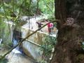
Vicki and Anniepoo at the spot.
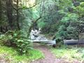
Another view of the spot.


Achievements
This is going to be our officially redeclared mouseover day!!
If anyone wants to shoot for it, this will be an easy no-batteries hash. Also, GoogleMaps shows the creek further West, but I believe it may be VERY close to the spot, in which case also a water-hash.
I'll let her decide if she wants to take it, but I'd definitely back Anniepoo for an Extreme Dedication hash!
Truly sad that we didn't reach the hash. Otherwise everybody but Annie would have gotten Couch Potato Geohash Honorable Mention.
Ted, Anniepoo, Vicki, Rose, Roxanne earned the Cliffs of Despair consolation prize
|
Rose & Roxanne would have qualified for Restricted Area if we'd made it.
Ted wins Radio Yerevan on the OpenStreetMap achievement, as he convinced Google to change the location of the road so it wasn't in the midst of the creek.
Vicki says she's been to that spot before, but had no proof.
And of course Ted did a masterful job getting us in with the dogs. (Nope, reaching the point's not required - just permission to get to the point)
Ted earned the Ambassador achievement
|
And since we, by the magic of consensus thinking, had moved #towelday to Sunday, all get
Ted, Anniepoo, Vicki, Rose, Roxanne earned the 2013 Mouse Over Day achievement
|