Difference between revisions of "2013-06-02 41 -71"
imported>Vbob |
m (Location correction) |
||
| (3 intermediate revisions by 3 users not shown) | |||
| Line 42: | Line 42: | ||
Loop around the woodlands and find the other end of the abandoned road, and abandon Bruce with her Sunday newspaper in a shady pullout. | Loop around the woodlands and find the other end of the abandoned road, and abandon Bruce with her Sunday newspaper in a shady pullout. | ||
Trails in the woodlands wander towards the geohash, and then the GPS batteries die. Put the camera batteries in the GPS, and get an accuracy 'within 200 feet' under heavy tree canopy, with the most likely location off the trail through a thicket of poison ivy. | Trails in the woodlands wander towards the geohash, and then the GPS batteries die. Put the camera batteries in the GPS, and get an accuracy 'within 200 feet' under heavy tree canopy, with the most likely location off the trail through a thicket of poison ivy. | ||
| − | What's the difference between gave up, tried hard enough, came really close, and rather come back when my wife can walk it also? | + | What's the difference between gave up, tried hard enough, came really close, need more batteries, and rather come back when my wife can walk it also? |
| + | |||
| + | Beautiful quiet woods, with only one notable pile of tires on the side of the access road to trailhead - so we WILL come back, with a more trucklike vehicle, and pack out the trash. | ||
== Tracklog == | == Tracklog == | ||
| Line 52: | Line 54: | ||
--> | --> | ||
<gallery perrow="5"> | <gallery perrow="5"> | ||
| + | Image:2013.06.02a-Bruce-at-trailhead.jpg | Booted Bruce beckons | ||
| + | Image:2013.06.02b-Cabrio-at-road.jpg | Convertible car creeps | ||
| + | Image:2013.06.02c-road-becomes-streambed.jpg | Rocky roadbed resists | ||
| + | Image:2013.06.02d-this-too-was-a-road.jpg | Treebound trailhead terminates | ||
| + | Image:2013.06.02e-close-but-no-batteries.jpg | close, but no batteries | ||
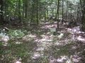
| + | Image:2013.06.02f-woodland-trail.jpg | and not much view of sky either | ||
| + | Image:2013.06.02g-foolish-grin.jpg | Foolish Grin™ | ||
| + | |||
</gallery> | </gallery> | ||
| Line 59: | Line 69: | ||
| − | |||
| − | |||
| − | |||
| − | |||
| − | |||
| − | |||
| − | |||
| − | |||
| − | |||
| − | |||
[[Category:Expeditions]] | [[Category:Expeditions]] | ||
| − | |||
[[Category:Expeditions with photos]] | [[Category:Expeditions with photos]] | ||
| − | |||
| − | |||
| − | |||
| − | |||
| − | |||
| − | |||
| − | |||
| − | |||
| − | |||
[[Category:Coordinates not reached]] | [[Category:Coordinates not reached]] | ||
| − | |||
| − | |||
[[Category:Not reached - Mother Nature]] | [[Category:Not reached - Mother Nature]] | ||
| − | + | {{location|US|RI|PR}} | |
| − | |||
| − | |||
| − | |||
| − | |||
| − | |||
| − | |||
| − | |||
| − | |||
| − | |||
| − | |||
Latest revision as of 20:19, 16 May 2020
| Sun 2 Jun 2013 in 41,-71: 41.7328189, -71.6843241 geohashing.info google osm bing/os kml crox |
Location
Parker Woodland Wildlife Refuge, Foster, Rhode Island
http://www.asri.org/images/Refuges/parker-woodland-trail-map-2.gif
somewhere near 'Old Farm Site' at top center of trail map
Participants
Bruce
Plans
Expedition
Driving back from Sunday visit to the grandsons, somewhat familiar roads become less and less paved, steeper and rockier... With Bruce's broken ankle in an inflatable boot, driving a low clearance convertible into the woods seems less prudent than usual. Loop around the woodlands and find the other end of the abandoned road, and abandon Bruce with her Sunday newspaper in a shady pullout. Trails in the woodlands wander towards the geohash, and then the GPS batteries die. Put the camera batteries in the GPS, and get an accuracy 'within 200 feet' under heavy tree canopy, with the most likely location off the trail through a thicket of poison ivy. What's the difference between gave up, tried hard enough, came really close, need more batteries, and rather come back when my wife can walk it also?
Beautiful quiet woods, with only one notable pile of tires on the side of the access road to trailhead - so we WILL come back, with a more trucklike vehicle, and pack out the trash.
Tracklog
Photos
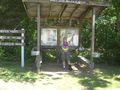
Booted Bruce beckons
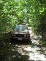
Convertible car creeps
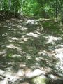
Rocky roadbed resists
Treebound trailhead terminates
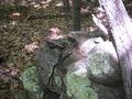
close, but no batteries
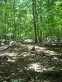
and not much view of sky either

Foolish Grin™


