Difference between revisions of "2013-07-31 32 -97"
imported>JasonKoller (→Achievements) |
imported>FippeBot m (Location) |
||
| (42 intermediate revisions by 3 users not shown) | |||
| Line 18: | Line 18: | ||
}} | }} | ||
| − | + | ||
__NOTOC__ | __NOTOC__ | ||
== Location == | == Location == | ||
| − | + | ||
| + | [[User:JasonKoller|Jason Koller]]'s first GeoHash. | ||
| + | Near a sleepy little neighborhood by an empty creek. | ||
== Participants == | == Participants == | ||
| − | + | ||
| − | + | * [[User:JasonKoller|Jason Koller]] | |
| − | [[User:JasonKoller|Jason Koller]] | ||
== Plans == | == Plans == | ||
| − | |||
The plan is the leave work at 5pm, <br> | The plan is the leave work at 5pm, <br> | ||
| − | Fight | + | Fight through the traffic,<br> |
And stop by the GeoHash on the way to the gym.<br> | And stop by the GeoHash on the way to the gym.<br> | ||
The only thing I see going wrong here is "gym" turning into some form of fast food.<br> | The only thing I see going wrong here is "gym" turning into some form of fast food.<br> | ||
But the gym isn't actually part of the GeoHash, so I expect this to be a success regardless of how much I eat.<br> | But the gym isn't actually part of the GeoHash, so I expect this to be a success regardless of how much I eat.<br> | ||
This will be my first GeoHash.<br> | This will be my first GeoHash.<br> | ||
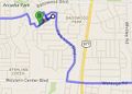
| − | [[File:2013-07-31_32_-97_Plan.JPG]] [ | + | [[File:2013-07-31_32_-97_Plan.JPG]]<br> |
| + | [http://goo.gl/maps/lYeXS Google Maps Planned Route] <br> | ||
== Expedition == | == Expedition == | ||
| − | < | + | So...<br> |
| + | I started at Starbucks so I could use there wifi and down load the GeoHash app and hopefully an app that would create a track log for my Nexus one.<br> | ||
| + | No such luck. <br> | ||
| + | My Nexus One has that odd issue out there where the power button stops working. <br> | ||
| + | I downloaded an app that allows me to use the volume button in place of the power button, but it doesn't always work. <br> | ||
| + | And I haven't have a chance to install CyanogenMod on it so I can use the wake from trackball mod.<br> | ||
| + | <br> | ||
| + | Fortunately, due to my innate sense of direction,<br> | ||
| + | And the copy of Google Maps I printed out because I was expecting this to happen,<br> | ||
| + | I was still able to make it.<br> | ||
| + | So I guess this means I get the [[No_Batteries_Geohash|No Batteries Geohash]] as opposed to the [[Blinded_by_Science|Blinded by Science]]? <br> | ||
| + | <br> | ||
| + | Since I didn't have a navigation system,<br> | ||
| + | And the map I printed was zoomed too far in,<br> | ||
| + | I got a bit lost on my way out.<br> | ||
| + | <del>I did my best not to cross my tracks on the way out since I was hoping to get an easy [[Tron_achievement|Tron Achievement]].<br> | ||
| + | I took a wrong turn some where and ended up in a Cul-de-sac. | ||
| + | Because of the route I ended up taking and since I was driving on the right-hand side of the road,<br> | ||
| + | I never technically crossed my own path,<br> | ||
| + | Even if I drove down the same street a second time in the opposite direction.<br> | ||
| + | I'm going to go ahead and claim it until someone tells me I can't.<br> | ||
| + | "They" say it's better to beg forgiveness then ask permission.<br> | ||
| + | Whoever "they" are...<br></del> | ||
| + | <ins>As pointed out by [[User:Benjw|Benjw]], I did not in fact earn the Tron Achievement as I did not return to my point of origin.<br> | ||
| + | My mistake. Thanks for keeping me honest</ins><br> | ||
| + | [[File:2013-07-31_32_-97_Actual.JPG]]<br> | ||
| + | [http://goo.gl/maps/GXuX6 Google Maps Actual Route] <br> | ||
| + | <br> | ||
| + | Alas, I did not actually make it to the gym.<br> | ||
| + | I went to Schlotzsky's instead.<br> | ||
| + | And it gets even better!<br> | ||
| + | The guy in front of me in the drive through paid for my meal!<br> | ||
| + | I tried to pay for the guy behind me,<br> | ||
| + | But there was nobody there.<br> | ||
== Tracklog == | == Tracklog == | ||
<!-- if your GPS device keeps a log, you may post a link here --> | <!-- if your GPS device keeps a log, you may post a link here --> | ||
| + | [http://goo.gl/maps/GXuX6|Maps Google Maps]<br> | ||
== Photos == | == Photos == | ||
| Line 49: | Line 84: | ||
--> | --> | ||
<gallery perrow="5"> | <gallery perrow="5"> | ||
| + | File:2013-07-31_Stupid_Grin.jpg | Stupid Grin | ||
| + | File:2013-07-31_Three_Trees.jpg | Three Trees | ||
| + | File:2013-07-31_Dry_Creek.jpg | Dry Creek | ||
| + | File:2013-07-31_Shell_Creek_Creek_Bend.jpg | First Street Sign | ||
| + | File:2013-07-31_Shell_Creek_Buena_Vista.jpg | Second Street Sign | ||
| + | File:2013-07-31_32_-97_Actual.JPG|Actual Route | Actual Route | ||
</gallery> | </gallery> | ||
== Achievements == | == Achievements == | ||
{{#vardefine:ribbonwidth|800px}} | {{#vardefine:ribbonwidth|800px}} | ||
| − | + | ||
{{land geohash | {{land geohash | ||
| Line 59: | Line 100: | ||
| latitude = 32 | | latitude = 32 | ||
| longitude = -97 | | longitude = -97 | ||
| − | | date = | + | | date = 2013-07-31 |
| name = [[User:JasonKoller|Jason Koller]] | | name = [[User:JasonKoller|Jason Koller]] | ||
| − | |||
}} | }} | ||
| − | {{ | + | {{No_batteries_geohash |
| latitude = 32 | | latitude = 32 | ||
| longitude = -97 | | longitude = -97 | ||
| − | | date = | + | | date = 2013-07-31 |
| − | + | | name = [[User:JasonKoller|Jason Koller]] | |
| − | |||
| − | | name = [[User:JasonKoller|Jason Koller | ||
| − | |||
| − | }} | + | }} |
| + | {{Radio Yerevan | ||
| + | | achievement = Tron achievement | ||
| + | | detail = he did not return to his starting point | ||
| + | | date = 2013-07-31 | ||
| + | | latitude = 32 | ||
| + | | longitude = -97 | ||
| + | | user = [[User:JasonKoller|Jason Koller]] | ||
| + | }} | ||
| − | + | == Other Geohashes on [[2013-07-31]] == | |
| − | |||
| − | |||
| − | + | {{expedition summaries|2013-07-31}} | |
| − | |||
| − | |||
| − | |||
| − | |||
[[Category:Expeditions]] | [[Category:Expeditions]] | ||
| − | |||
| − | |||
| − | |||
[[Category:Expedition without GPS]] | [[Category:Expedition without GPS]] | ||
| − | + | [[Category:Expeditions with photos]] | |
| − | |||
| − | |||
[[Category:Coordinates reached]] | [[Category:Coordinates reached]] | ||
| − | + | {{location|US|TX|TN}} | |
| − | |||
| − | |||
| − | |||
| − | |||
| − | |||
| − | |||
| − | |||
| − | |||
| − | |||
| − | |||
| − | |||
| − | |||
| − | |||
| − | |||
| − | |||
| − | |||
| − | |||
Latest revision as of 03:23, 14 August 2019
| Wed 31 Jul 2013 in Fort Worth, Texas: 32.8701476, -97.2725689 geohashing.info google osm bing/os kml crox |
Location
Jason Koller's first GeoHash. Near a sleepy little neighborhood by an empty creek.
Participants
Plans
The plan is the leave work at 5pm,
Fight through the traffic,
And stop by the GeoHash on the way to the gym.
The only thing I see going wrong here is "gym" turning into some form of fast food.
But the gym isn't actually part of the GeoHash, so I expect this to be a success regardless of how much I eat.
This will be my first GeoHash.

Google Maps Planned Route
Expedition
So...
I started at Starbucks so I could use there wifi and down load the GeoHash app and hopefully an app that would create a track log for my Nexus one.
No such luck.
My Nexus One has that odd issue out there where the power button stops working.
I downloaded an app that allows me to use the volume button in place of the power button, but it doesn't always work.
And I haven't have a chance to install CyanogenMod on it so I can use the wake from trackball mod.
Fortunately, due to my innate sense of direction,
And the copy of Google Maps I printed out because I was expecting this to happen,
I was still able to make it.
So I guess this means I get the No Batteries Geohash as opposed to the Blinded by Science?
Since I didn't have a navigation system,
And the map I printed was zoomed too far in,
I got a bit lost on my way out.
I did my best not to cross my tracks on the way out since I was hoping to get an easy Tron Achievement.
As pointed out by Benjw, I did not in fact earn the Tron Achievement as I did not return to my point of origin.
I took a wrong turn some where and ended up in a Cul-de-sac.
Because of the route I ended up taking and since I was driving on the right-hand side of the road,
I never technically crossed my own path,
Even if I drove down the same street a second time in the opposite direction.
I'm going to go ahead and claim it until someone tells me I can't.
"They" say it's better to beg forgiveness then ask permission.
Whoever "they" are...
My mistake. Thanks for keeping me honest

Google Maps Actual Route
Alas, I did not actually make it to the gym.
I went to Schlotzsky's instead.
And it gets even better!
The guy in front of me in the drive through paid for my meal!
I tried to pay for the guy behind me,
But there was nobody there.
Tracklog
Photos

Stupid Grin
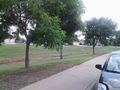
Three Trees
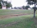
Dry Creek
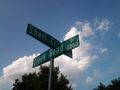
First Street Sign
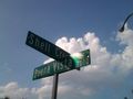
Second Street Sign
Actual Route


Achievements
Jason Koller earned the Land geohash achievement
|
Jason Koller earned the No Batteries Geohash Achievement
|
Is it true that Jason Koller earned the Tron achievement?
|
Other Geohashes on 2013-07-31
Expeditions and Plans
| 2013-07-31 | ||
|---|---|---|
| Fort Worth, Texas | Jason Koller | Jason Koller's first GeoHash. Near a sleepy little neighborhood by an empty... |
| Atlanta, Georgia | NWoodruff | Out back of the Mercer University campus in Chamblee. |
| Zürich, Switzerland | Calamus | A grove in Frauenfeld. |
| Rovaniemi, Finland | isopekka | Near Hyytiäntie, in the forest behind private houses. |