Difference between revisions of "2013-08-03 52 0"
imported>Benjw (deploy expedition template) |
imported>FippeBot m (Location) |
||
| (9 intermediate revisions by 2 users not shown) | |||
| Line 1: | Line 1: | ||
| − | + | <!-- [[Image:{{{image|IMAGE}}}|thumb|left]] --> | |
| − | <!-- | + | {{meetup graticule |
| − | |||
| − | [[Image:{{{image|IMAGE}}}|thumb|left]] | ||
| − | |||
| − | |||
| − | |||
| − | |||
| − | |||
| − | --> | ||
| − | {{meetup graticule | ||
| lat=52 | | lat=52 | ||
| lon=0 | | lon=0 | ||
| date=2013-08-03 | | date=2013-08-03 | ||
| + | | graticule_name=Cambridge, UK | ||
| + | | graticule_link=Cambridge, United Kingdom | ||
}} | }} | ||
| − | |||
| − | |||
| − | |||
== Location == | == Location == | ||
| − | + | The west bank of the River Great Ouse just south of Kings Lynn, at the appropriately named Eau Brink Road. | |
== Participants == | == Participants == | ||
| − | + | * [[User:Benjw|Benjw]] | |
| − | -- | + | * [[User:PaintedJaguar|PaintedJaguar]] |
| + | {{User:Benjw/multihash|2013-08-03 52 0|2013-08-04 52 0}} | ||
== Plans == | == Plans == | ||
| − | + | Given that [[2013-08-04 52 0|the next day's hashpoint]] is so near here, Ben plans to combine both into a nighttime expedition, driving up from Cambridge and visiting Saturday's hash just before midnight, and Sunday's hash just after. He's very happy to change those plans or to give other hashers a lift if anyone else is interested. | |
| + | |||
| + | The Great Ouse is tidal at this point, but, conveniently, low tide is at 00:47 so with a bit of luck the hashpoint will be on the river bank and not in the water. | ||
== Expedition == | == Expedition == | ||
| − | + | Benjw offered to collect PaintedJaguar and drive both to the hashpoint, and they set off from Cambridge at about 10pm, and they reached Eau Brink Road relatively easily after just over an hour's driving. Unfortunately the riverbank was surrounded by barbed wire fencing, and, after driving down the road further to look for access routes, a locked gate. Not to be beaten this easily, they then set off on foot alongside the barbed wire fence and away from the hashpoint to look for an accessible route up to the riverbank. | |
| + | |||
| + | After crossing a stile they found a path up to the top of the riverbank, and from there, they found a gateway in the barbed wire fence that had no gate in it. They headed through the gateway and startled a herd of cows, who charged at high speed (fortunately away from Benjw and PainterJaguar, and not towards them). As they got close to the hashpoint, they realised they had to scramble down towards the river, but the hashpoint was still on dry land, so no need to get any feet wet, or wait for the tide to be fully out. | ||
| + | |||
| + | After trying some long exposure photos in the dark, they headed back to the car, noting that the cows could no longer be seen anywhere. | ||
| + | |||
| + | This expedition was: | ||
| + | * the second hash of a double hash for PaintedJaguar (see the earlier expedition at [[2013-08-03 51 -0]]) | ||
| + | * the first day of consecutive geohashing for both PaintedJaguar and Benjw, as they immediately continued to the next day's hashpoint at [[2013-08-04 52 0]], and also hashed the following day at [[2013-08-05 52 0]]. | ||
== Tracklog == | == Tracklog == | ||
| − | + | http://www.wikiloc.com/wikiloc/view.do?id=4964364 shows the tracklog from just north of Ely, to this hashpoint, and continues on to [[2013-08-04 52 0]]. | |
| − | == | + | == Photographic documentation == |
| − | |||
| − | |||
| − | |||
<gallery perrow="5"> | <gallery perrow="5"> | ||
| + | Image:2013-08-03 52 0 gps.jpg | Ben's GPS showing hashpoint reached | ||
| + | Image:2013-08-03_52_0_gps2.JPG | PaintedJaguar's GPS, showing not quite as close to the hashpoint as Ben's GPS, but still within the accuracy | ||
| + | Image:2013-08-03_52_0_grins.JPG | Silly grins, along with Hammersmith the hashscot | ||
| + | Image:2013-08-03_52_0_view.JPG | Long-exposure photo looking towards something vaguely interesting on the horizon. Probably King's Lynn. | ||
</gallery> | </gallery> | ||
| − | == | + | == Shiny ribbons earned == |
{{#vardefine:ribbonwidth|800px}} | {{#vardefine:ribbonwidth|800px}} | ||
| − | + | We missed 4pm and travelled together, so no Saturday meetup. We also missed midnight, we'd already met before this expedition, and we didn't end up in the river, so no other "interesting" ribbons. Just: | |
| + | {{land geohash | ||
| + | | latitude = 52 | ||
| + | | longitude = 0 | ||
| + | | date = 2013-08-03 | ||
| + | | name = [[User:Benjw|Benjw]] and [[User:PaintedJaguar|PaintedJaguar]] | ||
| + | }} | ||
| + | |||
| + | {{Regional geohashing | ||
| + | | name = PaintedJaguar | ||
| + | | region = Norfolk | ||
| + | | count = 2 | ||
| + | }} | ||
| + | |||
| + | {{Multihash2 | ||
| + | | date = 2013-08-03 | ||
| + | | count = 2 | ||
| + | | name = PaintedJaguar | ||
| + | }} | ||
| − | |||
| − | |||
| − | |||
| − | |||
| − | |||
| − | |||
| − | |||
| − | |||
[[Category:Expeditions]] | [[Category:Expeditions]] | ||
| − | |||
[[Category:Expeditions with photos]] | [[Category:Expeditions with photos]] | ||
| − | |||
| − | |||
| − | |||
| − | |||
| − | |||
[[Category:Coordinates reached]] | [[Category:Coordinates reached]] | ||
| − | + | {{location|GB|ENG|NFK}} | |
| − | |||
| − | |||
| − | |||
| − | |||
| − | |||
| − | |||
| − | |||
| − | |||
| − | |||
| − | |||
| − | |||
| − | |||
| − | |||
| − | |||
| − | |||
| − | |||
| − | |||
Latest revision as of 03:27, 14 August 2019
| Sat 3 Aug 2013 in Cambridge, UK: 52.7169253, 0.3540812 geohashing.info google osm bing/os kml crox |
Contents
Location
The west bank of the River Great Ouse just south of Kings Lynn, at the appropriately named Eau Brink Road.
Participants
| This expedition was part of a multihash by Benjw. For the other parts, see: | |||||
|---|---|---|---|---|---|
| 2013-08-03 52 0 | 2013-08-04 52 0 | ||||
Plans
Given that the next day's hashpoint is so near here, Ben plans to combine both into a nighttime expedition, driving up from Cambridge and visiting Saturday's hash just before midnight, and Sunday's hash just after. He's very happy to change those plans or to give other hashers a lift if anyone else is interested.
The Great Ouse is tidal at this point, but, conveniently, low tide is at 00:47 so with a bit of luck the hashpoint will be on the river bank and not in the water.
Expedition
Benjw offered to collect PaintedJaguar and drive both to the hashpoint, and they set off from Cambridge at about 10pm, and they reached Eau Brink Road relatively easily after just over an hour's driving. Unfortunately the riverbank was surrounded by barbed wire fencing, and, after driving down the road further to look for access routes, a locked gate. Not to be beaten this easily, they then set off on foot alongside the barbed wire fence and away from the hashpoint to look for an accessible route up to the riverbank.
After crossing a stile they found a path up to the top of the riverbank, and from there, they found a gateway in the barbed wire fence that had no gate in it. They headed through the gateway and startled a herd of cows, who charged at high speed (fortunately away from Benjw and PainterJaguar, and not towards them). As they got close to the hashpoint, they realised they had to scramble down towards the river, but the hashpoint was still on dry land, so no need to get any feet wet, or wait for the tide to be fully out.
After trying some long exposure photos in the dark, they headed back to the car, noting that the cows could no longer be seen anywhere.
This expedition was:
- the second hash of a double hash for PaintedJaguar (see the earlier expedition at 2013-08-03 51 -0)
- the first day of consecutive geohashing for both PaintedJaguar and Benjw, as they immediately continued to the next day's hashpoint at 2013-08-04 52 0, and also hashed the following day at 2013-08-05 52 0.
Tracklog
http://www.wikiloc.com/wikiloc/view.do?id=4964364 shows the tracklog from just north of Ely, to this hashpoint, and continues on to 2013-08-04 52 0.
Photographic documentation
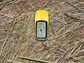
Ben's GPS showing hashpoint reached
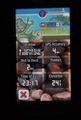
PaintedJaguar's GPS, showing not quite as close to the hashpoint as Ben's GPS, but still within the accuracy
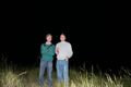
Silly grins, along with Hammersmith the hashscot
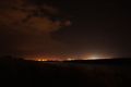
Long-exposure photo looking towards something vaguely interesting on the horizon. Probably King's Lynn.


Shiny ribbons earned
We missed 4pm and travelled together, so no Saturday meetup. We also missed midnight, we'd already met before this expedition, and we didn't end up in the river, so no other "interesting" ribbons. Just:
Benjw and PaintedJaguar earned the Land geohash achievement
|
PaintedJaguar earned the Regional geohashing achievement
|
PaintedJaguar earned the Multihash Achievement
|