Difference between revisions of "2013-08-24 47 11"
imported>LeslieHapablap (→Achievements) |
imported>FippeBot m (Location) |
||
| (34 intermediate revisions by 2 users not shown) | |||
| Line 1: | Line 1: | ||
| − | + | [[Image:20130824_145943.jpg|left|900px]] | |
| − | |||
| − | |||
| − | |||
| − | |||
| − | |||
| − | |||
| − | |||
| − | |||
| − | |||
| − | [[Image:20130824_145943.jpg| | ||
{{meetup graticule | {{meetup graticule | ||
| lat=47 | | lat=47 | ||
| Line 15: | Line 5: | ||
| date=2013-08-24 | | date=2013-08-24 | ||
}} | }} | ||
| − | + | {{ClearLeft}} | |
| − | + | {{quote|center|I think we are going to make it to the coordinates. — No, we will burst. |[[User:LeslieHapablap|LeslieHapablap]] while checking heading and distance on his GPS in difficult mountain terrain, and [[User:1-0|1-0]] while stuffing himself with wild blueberries. |width=500}} | |
__NOTOC__ | __NOTOC__ | ||
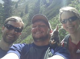
| + | [[File:2013-08-24 47 11 22-16-24-532.jpg|150px|thumb|left|The group.]] | ||
== Location == | == Location == | ||
| − | + | ||
Stubaital, near Mischbachalm. | Stubaital, near Mischbachalm. | ||
| − | |||
== Participants == | == Participants == | ||
| − | |||
| − | |||
* [[User:1-0|1-0]] | * [[User:1-0|1-0]] | ||
* [[User:EleanorAbernathy|EleanorAbernathy]] | * [[User:EleanorAbernathy|EleanorAbernathy]] | ||
| − | * [[User:LeslieHapablap|LeslieHapablap]] | + | * [[User:LeslieHapablap|LeslieHapablap]], ([[2013-06-29 48 11|previous]]|[[2013-09-10 48 11|next]]) |
| − | * Waltraud the hashkiwi | + | * [[User:LeslieHapablap/Waltraud|Waltraud]] the hashkiwi |
== Plans == | == Plans == | ||
| − | + | ||
The route we are [http://goo.gl/maps/wUAQt planning to take] has a [http://www.bergfex.at/sommer/tirol/touren/wanderung/17844,mischbachalm-bacherwandalm-ueber-gluecksgrat/ top rating], so we are very much looking forward to this tour. We hope to be at the hashpoint at 1pm, which is the official Saturday meetup time for this graticule. | The route we are [http://goo.gl/maps/wUAQt planning to take] has a [http://www.bergfex.at/sommer/tirol/touren/wanderung/17844,mischbachalm-bacherwandalm-ueber-gluecksgrat/ top rating], so we are very much looking forward to this tour. We hope to be at the hashpoint at 1pm, which is the official Saturday meetup time for this graticule. | ||
== Expedition == | == Expedition == | ||
| − | + | ||
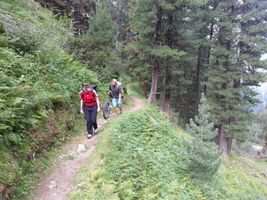
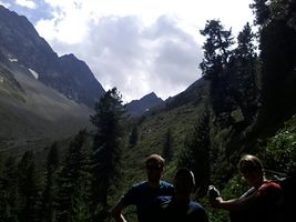
[[File:2013-08-24 47 11 22-40-23-301.jpg|300px|thumb|left|Our group got some strange looks by other people we met on the way.]] | [[File:2013-08-24 47 11 22-40-23-301.jpg|300px|thumb|left|Our group got some strange looks by other people we met on the way.]] | ||
| + | [[File:2013-08-24 47 11 22-03-11-828.jpg|300px|thumb|right|Mischbachalm.]] | ||
| + | [[File:2013-08-24 47 11 22-50-37-860.jpg|300px|thumb|right|1-0 on his way downhill.]] | ||
Yes, after a few months of inactivity the Tiroleans are back with more fun in the Alps. This time the Dow Jones sent us to the beautiful Stubai Valley, a very popular holiday region famous for its glacier at the end of the valley. The satellite images of the hashpoint looked very promising and in Google-Earth the terrain seemed not too steep (more on that later). Furthermore it was not too far off a hiking trail near an alpine cabin (the "Mischbachalm") where hikers can rest and enjoy simple but excellent meals. The weather forecast was okay for the day, so we decided to go for it. The route we planned to take was documented in a guide and described as a challenging but beautiful tour. | Yes, after a few months of inactivity the Tiroleans are back with more fun in the Alps. This time the Dow Jones sent us to the beautiful Stubai Valley, a very popular holiday region famous for its glacier at the end of the valley. The satellite images of the hashpoint looked very promising and in Google-Earth the terrain seemed not too steep (more on that later). Furthermore it was not too far off a hiking trail near an alpine cabin (the "Mischbachalm") where hikers can rest and enjoy simple but excellent meals. The weather forecast was okay for the day, so we decided to go for it. The route we planned to take was documented in a guide and described as a challenging but beautiful tour. | ||
| − | + | ||
This time [[User:1-0|1-0]] decided to take his unicycle with him. Just in case you wonder: yes, this is what he enjoys most, climbing on mountains and racing downhill on a unicycle. For some video footage have a look at his [http://1-0.at homepage]. | This time [[User:1-0|1-0]] decided to take his unicycle with him. Just in case you wonder: yes, this is what he enjoys most, climbing on mountains and racing downhill on a unicycle. For some video footage have a look at his [http://1-0.at homepage]. | ||
| − | |||
| − | After our lunch break we continued towards the hashpoint, which was only a few hundred meters away according to our | + | The first ascent was pretty steep and exhausting. Along the way there were wooden signs with little poems written on them to encourage guests of the Mischbachalm and tell them the remaining walking time to the destination. Here and there we stopped to eat some blueberries of which we found plenty on our way. We also spotted a black salamander, the little creature was not too impressed by our presence and strolled on slowly. The reward for the first 600m elevation gain was an excellent lunch and stunning views over the Stubai Valley at the Mischbachalm, a small and rustic wooden cabin with many animals around and very friendly owners. Some other guests were quite puzzled why on earth anyone would bring an unicycle and juggling clubs up a mountain. [[User:1-0|1-0]]'s explanation: this stuff is way easier on a mountain because gravity doesn't pull as hard. |
| + | |||
| + | [[File:20130824 134228.jpg|1000px|thumb|left|Panorama view of the hashpoint area.]] | ||
| + | [[Image:2013-08-24_47_11_22-47-10-498.jpg|300px|thumb|left|1-0 juggling at the highest point of the tour, with the Stubai glacier in the background]] | ||
| + | |||
| + | After our lunch break we continued towards the hashpoint, which was only a few hundred meters away according to our GPS device. However we learned soon that in the alpine terrain it is not always easy to figure out the optimal route to a given point, even when it is already close. After continuing on the hiking trail and climbing for some time we finally left the trail heading towards the hashpoint and made our way through bushes and more blueberries. Because it was clear now that sooner or later we would need our hands to move on, [[User:1-0|1-0]] left his unicycle behind to pick it up later. Even though we could only move very slowly, we steadily approached the hashpoint and hoped to reach it soon. But when the GPS showed a distance of 35 m, we found ourselves standing on the edge of a cliff with absolutely no way to go any further in that direction. We decided to go back and try to go around the cliff in order to approach the hashpoint from below instead of above, and indeed this proved to be the right strategy. After some more climbing the GPS finally confirmed that we had reached the coordinates. At 1pm we were within 200m of the hashpoint, but because of these difficulties it took us about 30 more minutes to reach it. Nevertheless we claim this to be a "Saturday meetup" because surely we would have met every other potential geohasher being there at the proper meetup time 1pm. | ||
| − | We moved a few meters away from the hashpoint | + | We moved a few meters away from the hashpoint to a place where it was easier to find a safe stand and took the obligatory group picture with the three of us and Waltraud the hashkiwi. Because it has become some sort of tradition by now [[User:1-0|1-0]] and [[User:LeslieHapablap|LeslieHapablap]] also juggled, with the added difficulty that any dropped club would immediately speed downhill for quite some distance (luckily we could recover them all). Encouraged by reaching the coordinates we returned to the trail, [[User:1-0|1-0]] picked up his unicycle and we continued on our regular route. |
| − | At the highest point ("Glücksgrat", roughly translates to "Ridge of Joy") we rested again, with a perfect view onto the Stubai glacier and some threatening rain clouds. From this point on it | + | At the highest point ("Glücksgrat", roughly translates to "Ridge of Joy") we rested again, with a perfect view onto the Stubai glacier and some threatening rain clouds. From this point on it paid out for [[User:1-0|1-0]] to carry his unicycle up, as he could now ride down to the valley whereas [[User:EleanorAbernathy|EleanorAbernathy]] and [[User:LeslieHapablap|LeslieHapablap]] had to walk all the way. Now and then [[User:1-0|1-0]] waited for the rest of the group, and finally we all arrived where we started almost eight hours earlier. As soon as we got back in the car it started to rain quite heavily.{{-}} |
== Tracklog == | == Tracklog == | ||
| − | + | ||
[[File:2013-08-24 elevation.png|400px|thumb|Elevation profile.]] | [[File:2013-08-24 elevation.png|400px|thumb|Elevation profile.]] | ||
| − | Our [http://goo.gl/maps/BKj06 tracklog] with a gap where the | + | Our [http://goo.gl/maps/BKj06 tracklog] with a gap where the GPS was accidentally not recording.{{-}} |
== Photos == | == Photos == | ||
| − | + | ||
| − | + | <gallery widths=300px heights=200 perrow="3"> | |
| − | |||
| − | <gallery widths= | ||
Image:2013-08-24_47_11_21-55-00-599.jpg | The starting point. | Image:2013-08-24_47_11_21-55-00-599.jpg | The starting point. | ||
| − | + | Image:2013-08-24_47_11_21-55-53-051.jpg | Forbidden for bikes with support wheel. | |
| − | Image:2013-08-24_47_11_21-55-53-051.jpg | | ||
| − | |||
Image:2013-08-24_47_11_21-56-22-629.jpg | Stubai Valley. | Image:2013-08-24_47_11_21-56-22-629.jpg | Stubai Valley. | ||
| − | |||
Image:2013-08-24_47_11_21-57-00-330.jpg | | Image:2013-08-24_47_11_21-57-00-330.jpg | | ||
| − | |||
Image:2013-08-24_47_11_21-57-36-845.jpg | Blueberries! | Image:2013-08-24_47_11_21-57-36-845.jpg | Blueberries! | ||
| − | |||
Image:2013-08-24_47_11_21-58-10-364.jpg | A salamander. | Image:2013-08-24_47_11_21-58-10-364.jpg | A salamander. | ||
| − | |||
Image:2013-08-24_47_11_21-59-09-297.jpg | | Image:2013-08-24_47_11_21-59-09-297.jpg | | ||
| − | |||
Image:2013-08-24_47_11_21-59-45-376.jpg | | Image:2013-08-24_47_11_21-59-45-376.jpg | | ||
| − | |||
Image:2013-08-24_47_11_22-00-44-312.jpg | | Image:2013-08-24_47_11_22-00-44-312.jpg | | ||
| − | |||
Image:2013-08-24_47_11_22-01-18-003.jpg | | Image:2013-08-24_47_11_22-01-18-003.jpg | | ||
| − | |||
Image:2013-08-24_47_11_22-02-11-763.jpg | Arriving at the Mischbachalm. | Image:2013-08-24_47_11_22-02-11-763.jpg | Arriving at the Mischbachalm. | ||
| − | |||
Image:2013-08-24_47_11_22-03-11-828.jpg | Mischbachalm | Image:2013-08-24_47_11_22-03-11-828.jpg | Mischbachalm | ||
| − | |||
Image:2013-08-24_47_11_22-03-48-814.jpg | Mischbachalm | Image:2013-08-24_47_11_22-03-48-814.jpg | Mischbachalm | ||
| − | |||
Image:2013-08-24_47_11_22-04-15-749.jpg | | Image:2013-08-24_47_11_22-04-15-749.jpg | | ||
| − | |||
Image:2013-08-24_47_11_22-06-22-386.jpg | | Image:2013-08-24_47_11_22-06-22-386.jpg | | ||
| − | |||
Image:2013-08-24_47_11_22-08-28-418.jpg | More blueberries! | Image:2013-08-24_47_11_22-08-28-418.jpg | More blueberries! | ||
| − | |||
Image:2013-08-24_47_11_22-09-04-190.jpg | Off-track searching for the hashpoint. | Image:2013-08-24_47_11_22-09-04-190.jpg | Off-track searching for the hashpoint. | ||
| − | |||
Image:2013-08-24_47_11_22-10-15-943.jpg | 35 m away down that cliff... No way :-( | Image:2013-08-24_47_11_22-10-15-943.jpg | 35 m away down that cliff... No way :-( | ||
| − | |||
Image:2013-08-24_47_11_22-11-14-194.jpg | We have to go around and try from the other direction. | Image:2013-08-24_47_11_22-11-14-194.jpg | We have to go around and try from the other direction. | ||
| − | + | Image:2013-08-24_47_11_22-12-35-524.jpg | Success! No hashkiwis were harmed during the making of this photo. | |
| − | Image:2013-08-24_47_11_22-12-35-524.jpg | Success! | ||
| − | |||
Image:2013-08-24_47_11_22-13-16-056.jpg | Obligatory proof. | Image:2013-08-24_47_11_22-13-16-056.jpg | Obligatory proof. | ||
| − | |||
Image:2013-08-24_47_11_22-15-27-599.jpg | Why it is a bad idea to take pictures facing the sun... | Image:2013-08-24_47_11_22-15-27-599.jpg | Why it is a bad idea to take pictures facing the sun... | ||
| − | |||
Image:2013-08-24_47_11_22-16-24-532.jpg | Obligatory stupid grin. | Image:2013-08-24_47_11_22-16-24-532.jpg | Obligatory stupid grin. | ||
| − | |||
Image:2013-08-24_47_11_22-33-34-978.jpg | Obligatory juggling at the hashpoint. | Image:2013-08-24_47_11_22-33-34-978.jpg | Obligatory juggling at the hashpoint. | ||
| − | |||
Image:2013-08-24_47_11_22-34-17-212.jpg | This one got away... | Image:2013-08-24_47_11_22-34-17-212.jpg | This one got away... | ||
| − | + | Image:2013-08-24_47_11_22-35-04-041.jpg | ... and went pretty far down (still falling in this picture). | |
| − | Image:2013-08-24_47_11_22-35-04-041.jpg | ... pretty far down. | ||
| − | |||
Image:2013-08-24_47_11_22-36-17-087.jpg | LeslieHapablap juggling with head balance. | Image:2013-08-24_47_11_22-36-17-087.jpg | LeslieHapablap juggling with head balance. | ||
| − | |||
Image:2013-08-24_47_11_22-39-29-333.jpg | Approaching "Glücksgrat" | Image:2013-08-24_47_11_22-39-29-333.jpg | Approaching "Glücksgrat" | ||
| − | |||
Image:2013-08-24_47_11_22-39-56-462.jpg | | Image:2013-08-24_47_11_22-39-56-462.jpg | | ||
| − | |||
Image:2013-08-24_47_11_22-40-23-301.jpg | | Image:2013-08-24_47_11_22-40-23-301.jpg | | ||
| − | + | Image:2013-08-24_47_11_22-47-10-498.jpg | [[User:1-0|1-0]] juggling at the highest point of the tour, with the Stubai glacier in the background | |
| − | Image:2013-08-24_47_11_22-47-10-498.jpg | 1-0 juggling at the highest point of the tour, with the Stubai glacier in the background | + | Image:2013-08-24_47_11_22-50-37-860.jpg | [[User:1-0|1-0]] decides to ignore gravity and gets away with it. |
| − | |||
| − | Image:2013-08-24_47_11_22-50-37-860.jpg | 1-0 decides to ignore gravity and gets away with it. | ||
| − | |||
Image:2013-08-24_47_11_22-50-53-884.jpg | | Image:2013-08-24_47_11_22-50-53-884.jpg | | ||
| − | |||
Image:2013-08-24_47_11_22-48-07-195.jpg | | Image:2013-08-24_47_11_22-48-07-195.jpg | | ||
| − | |||
Image:2013-08-24_47_11_22-58-18-284.jpg | | Image:2013-08-24_47_11_22-58-18-284.jpg | | ||
| − | |||
Image:2013-08-24_47_11_22-58-39-448.jpg | | Image:2013-08-24_47_11_22-58-39-448.jpg | | ||
| − | |||
Image:2013-08-24_47_11_22-59-27-152.jpg | | Image:2013-08-24_47_11_22-59-27-152.jpg | | ||
| − | |||
Image:2013-08-24_47_11_23-04-54-109.jpg | | Image:2013-08-24_47_11_23-04-54-109.jpg | | ||
| − | |||
Image:2013-08-24_47_11_23-06-43-563.jpg | | Image:2013-08-24_47_11_23-06-43-563.jpg | | ||
| − | |||
Image:2013-08-24_47_11_23-07-15-123.jpg | | Image:2013-08-24_47_11_23-07-15-123.jpg | | ||
</gallery> | </gallery> | ||
| Line 143: | Line 96: | ||
== Achievements == | == Achievements == | ||
{{#vardefine:ribbonwidth|800px}} | {{#vardefine:ribbonwidth|800px}} | ||
| − | |||
| + | {{land geohash | ||
| + | |||
| + | | latitude = 47 | ||
| + | | longitude = 11 | ||
| + | | date = 2013-08-24 | ||
| + | | name = [[User:EleanorAbernathy|EleanorAbernathy]], [[User:LeslieHapablap|LeslieHapablap]] and [[User:1-0|1-0]] | ||
| + | |||
| + | }} | ||
| + | {{Circus_geohash | ||
| + | |||
| + | | latitude = 47 | ||
| + | | longitude = 11 | ||
| + | | date = 2013-08-24 | ||
| + | | name = [[User:1-0|1-0]], [[User:LeslieHapablap|LeslieHapablap]] | ||
| + | | performance = juggling and unicycling | ||
| + | |||
| + | }} | ||
| + | {{Two to the N achievement | ||
| − | + | | latitude = 47 | |
| − | + | | longitude = 11 | |
| + | | date = 2013-08-24 | ||
| + | | name = [[User:LeslieHapablap|LeslieHapablap]] | ||
| + | | count=3 | ||
| + | | reached=True | ||
| + | }} | ||
| − | |||
| − | |||
| − | |||
| − | |||
[[Category:Expeditions]] | [[Category:Expeditions]] | ||
[[Category:Expeditions with photos]] | [[Category:Expeditions with photos]] | ||
| − | |||
| − | |||
| − | |||
| − | |||
| − | |||
| − | |||
| − | |||
[[Category:Coordinates reached]] | [[Category:Coordinates reached]] | ||
| − | + | {{location|AT|T|IL}} | |
| − | |||
| − | |||
| − | |||
| − | |||
| − | |||
| − | |||
| − | |||
| − | |||
| − | |||
| − | |||
| − | |||
| − | |||
| − | |||
| − | |||
| − | |||
| − | |||
| − | |||
Latest revision as of 03:41, 14 August 2019

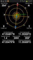
| Sat 24 Aug 2013 in 47,11: 47.0548144, 11.2656973 geohashing.info google osm bing/os kml crox |
| “ | I think we are going to make it to the coordinates. — No, we will burst.
|
” |
—LeslieHapablap while checking heading and distance on his GPS in difficult mountain terrain, and 1-0 while stuffing himself with wild blueberries.
| ||

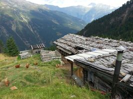
Location
Stubaital, near Mischbachalm.
Participants
- 1-0
- EleanorAbernathy
- LeslieHapablap, (previous|next)
- Waltraud the hashkiwi
Plans
The route we are planning to take has a top rating, so we are very much looking forward to this tour. We hope to be at the hashpoint at 1pm, which is the official Saturday meetup time for this graticule.
Expedition


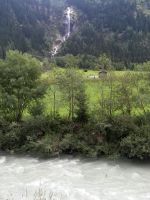
Yes, after a few months of inactivity the Tiroleans are back with more fun in the Alps. This time the Dow Jones sent us to the beautiful Stubai Valley, a very popular holiday region famous for its glacier at the end of the valley. The satellite images of the hashpoint looked very promising and in Google-Earth the terrain seemed not too steep (more on that later). Furthermore it was not too far off a hiking trail near an alpine cabin (the "Mischbachalm") where hikers can rest and enjoy simple but excellent meals. The weather forecast was okay for the day, so we decided to go for it. The route we planned to take was documented in a guide and described as a challenging but beautiful tour.
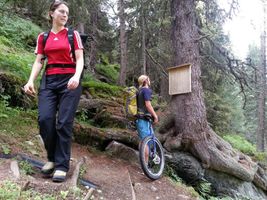
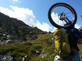
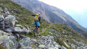
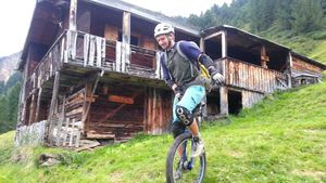
This time 1-0 decided to take his unicycle with him. Just in case you wonder: yes, this is what he enjoys most, climbing on mountains and racing downhill on a unicycle. For some video footage have a look at his homepage.
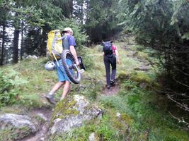
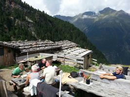
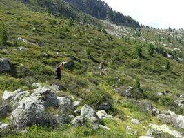
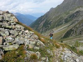
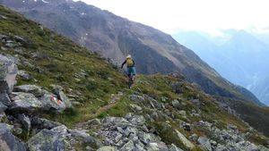
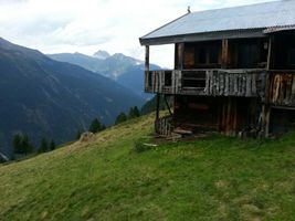
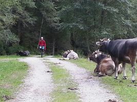
The first ascent was pretty steep and exhausting. Along the way there were wooden signs with little poems written on them to encourage guests of the Mischbachalm and tell them the remaining walking time to the destination. Here and there we stopped to eat some blueberries of which we found plenty on our way. We also spotted a black salamander, the little creature was not too impressed by our presence and strolled on slowly. The reward for the first 600m elevation gain was an excellent lunch and stunning views over the Stubai Valley at the Mischbachalm, a small and rustic wooden cabin with many animals around and very friendly owners. Some other guests were quite puzzled why on earth anyone would bring an unicycle and juggling clubs up a mountain. 1-0's explanation: this stuff is way easier on a mountain because gravity doesn't pull as hard.


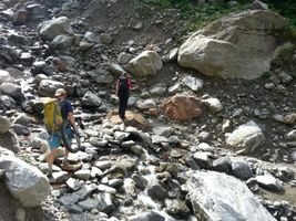
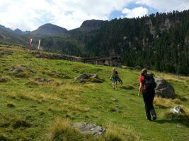
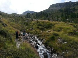
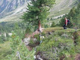
After our lunch break we continued towards the hashpoint, which was only a few hundred meters away according to our GPS device. However we learned soon that in the alpine terrain it is not always easy to figure out the optimal route to a given point, even when it is already close. After continuing on the hiking trail and climbing for some time we finally left the trail heading towards the hashpoint and made our way through bushes and more blueberries. Because it was clear now that sooner or later we would need our hands to move on, 1-0 left his unicycle behind to pick it up later. Even though we could only move very slowly, we steadily approached the hashpoint and hoped to reach it soon. But when the GPS showed a distance of 35 m, we found ourselves standing on the edge of a cliff with absolutely no way to go any further in that direction. We decided to go back and try to go around the cliff in order to approach the hashpoint from below instead of above, and indeed this proved to be the right strategy. After some more climbing the GPS finally confirmed that we had reached the coordinates. At 1pm we were within 200m of the hashpoint, but because of these difficulties it took us about 30 more minutes to reach it. Nevertheless we claim this to be a "Saturday meetup" because surely we would have met every other potential geohasher being there at the proper meetup time 1pm.
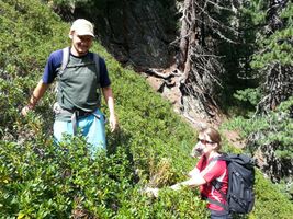
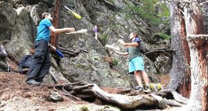
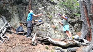
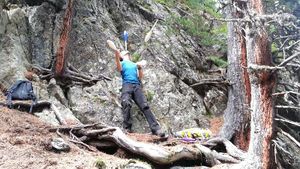
We moved a few meters away from the hashpoint to a place where it was easier to find a safe stand and took the obligatory group picture with the three of us and Waltraud the hashkiwi. Because it has become some sort of tradition by now 1-0 and LeslieHapablap also juggled, with the added difficulty that any dropped club would immediately speed downhill for quite some distance (luckily we could recover them all). Encouraged by reaching the coordinates we returned to the trail, 1-0 picked up his unicycle and we continued on our regular route.
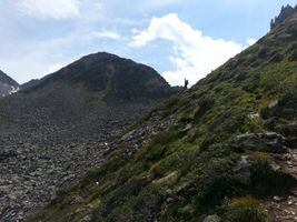
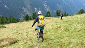
At the highest point ("Glücksgrat", roughly translates to "Ridge of Joy") we rested again, with a perfect view onto the Stubai glacier and some threatening rain clouds. From this point on it paid out for 1-0 to carry his unicycle up, as he could now ride down to the valley whereas EleanorAbernathy and LeslieHapablap had to walk all the way. Now and then 1-0 waited for the rest of the group, and finally we all arrived where we started almost eight hours earlier. As soon as we got back in the car it started to rain quite heavily.
Tracklog

Our tracklog with a gap where the GPS was accidentally not recording.
Photos
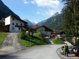
The starting point.
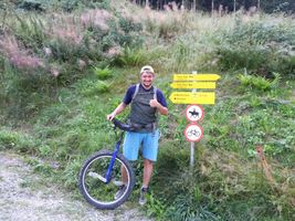
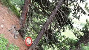
Forbidden for bikes with support wheel.
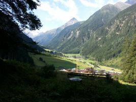
Stubai Valley.
Blueberries!
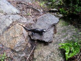
A salamander.
Arriving at the Mischbachalm.
Mischbachalm
Mischbachalm
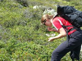
More blueberries!
Off-track searching for the hashpoint.
35 m away down that cliff... No way :-(
We have to go around and try from the other direction.
Success! No hashkiwis were harmed during the making of this photo.
Obligatory proof.
Why it is a bad idea to take pictures facing the sun...
Obligatory stupid grin.
Obligatory juggling at the hashpoint.
This one got away...
... and went pretty far down (still falling in this picture).
LeslieHapablap juggling with head balance.
Approaching "Glücksgrat"

1-0 juggling at the highest point of the tour, with the Stubai glacier in the background
1-0 decides to ignore gravity and gets away with it.


Achievements
EleanorAbernathy, LeslieHapablap and 1-0 earned the Land geohash achievement
|
1-0, LeslieHapablap earned the Circus Geohash Achievement
|
