Difference between revisions of "2013-10-19 45 -122"
From Geohashing
imported>Michael5000 |
Michael5000 (talk | contribs) (→Plans) |
||
| (2 intermediate revisions by 2 users not shown) | |||
| Line 15: | Line 15: | ||
[[User:Michael5000|Michael5000]]: Expedition #147 | [[User:Michael5000|Michael5000]]: Expedition #147 | ||
| − | |||
| − | |||
| − | |||
== Expedition == | == Expedition == | ||
An easy drive-over on a country lane not too far off the interstate, this was conveniently located on a day when I was heading to Tacoma. | An easy drive-over on a country lane not too far off the interstate, this was conveniently located on a day when I was heading to Tacoma. | ||
| + | |||
| + | EDIT: I forgot to mention the best part! There were five or six llamas at the hashpoint. Or rather, behind a fence near the hashpoint. You could tell that they were kind of frustrated because, for them, it was a "Could not complete -- no livestock access" expedition. | ||
== Photos == | == Photos == | ||
| Line 40: | Line 39: | ||
[[Category:Coordinates reached]] | [[Category:Coordinates reached]] | ||
| + | {{location|US|WA|CR}} | ||
Latest revision as of 20:12, 16 April 2022
| Sat 19 Oct 2013 in 45,-122: 45.8302104, -122.6963933 geohashing.info google osm bing/os kml crox |
Location
On NW 289th Street in Clark County.
Participants
Michael5000: Expedition #147
Expedition
An easy drive-over on a country lane not too far off the interstate, this was conveniently located on a day when I was heading to Tacoma.
EDIT: I forgot to mention the best part! There were five or six llamas at the hashpoint. Or rather, behind a fence near the hashpoint. You could tell that they were kind of frustrated because, for them, it was a "Could not complete -- no livestock access" expedition.
Photos
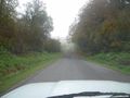
The hashpoint was about a kilometer down this road. One picture, and my camera battery died.
