2013-11-02 35 -118
From Geohashing
Revision as of 20:12, 2 November 2013 by imported>Captnemo42 (→Plans)
| Sun 22 Jul 2012 in 55,-17: 55.5994754, -17.7209116 geohashing.info google osm bing/os kml crox |
Location
Meetup location:
- 35.742574°, -118.721948° or
- N35°44.5544', W118°43.3168' or
- N35°44'33.26", W118°43'19.01"
I'm heading out to try and reach the coordinates by 4pm today, Saturday 11/2, if anyone cares to try and meet me- looks like it may be acessible as its only 300' from a road.
Participants
Plans
Meetup location:
- 35.742574°, -118.721948° or
- N35°44.5544', W118°43.3168' or
- N35°44'33.26", W118°43'19.01"
Expedition
This is only an example.
Tracklog
Most people delete this section. It's useful for some.
Photos
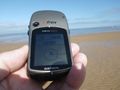
This is an example of good evidence

Achievements
Sourcerer earned the Water geohash achievement
|