Difference between revisions of "2013-11-22 48 11"
imported>LeslieHapablap ([retro] We have been there! Report and photos to follow.) |
imported>FippeBot m (Location) |
||
| (24 intermediate revisions by one other user not shown) | |||
| Line 1: | Line 1: | ||
| − | <!-- | + | <!-- Iory f you did not specify these parameters in the template, please substitute appropriate values for IMAGE, LAT, LON, and DATE (YYYY-MM-DD format) |
[[Image:{{{image|IMAGE}}}|thumb|left]] | [[Image:{{{image|IMAGE}}}|thumb|left]] | ||
| Line 9: | Line 9: | ||
And DON'T FORGET to add your expedition and the best photo you took to the gallery on the Main Page! We'd love to read your report, but that means we first have to discover it! :) | And DON'T FORGET to add your expedition and the best photo you took to the gallery on the Main Page! We'd love to read your report, but that means we first have to discover it! :) | ||
--> | --> | ||
| + | [[File:20131122-161512.jpg|left|900px]] | ||
{{meetup graticule | {{meetup graticule | ||
| lat=48 | | lat=48 | ||
| Line 14: | Line 15: | ||
| date=2013-11-22 | | date=2013-11-22 | ||
}} | }} | ||
| − | + | {{ClearLeft}} | |
<!-- edit as necessary --> | <!-- edit as necessary --> | ||
__NOTOC__ | __NOTOC__ | ||
| + | [[File:2013-11-22 48 11 23-47-26-950.jpg|180px|thumb|left|The three of us and Waltraud.]] | ||
== Location == | == Location == | ||
<!-- where you've surveyed the hash to be --> | <!-- where you've surveyed the hash to be --> | ||
| + | In a forest near Gelbelsee, close to the A9 motorway. | ||
== Participants == | == Participants == | ||
<!-- who attended: If you link to your wiki user name in this section, your expedition will be picked up by the various statistics generated for geohashing. You may use three tildes ~ as a shortcut to automatically insert the user signature of the account you are editing with. | <!-- who attended: If you link to your wiki user name in this section, your expedition will be picked up by the various statistics generated for geohashing. You may use three tildes ~ as a shortcut to automatically insert the user signature of the account you are editing with. | ||
--> | --> | ||
| − | + | * [[User:OwlOnAWheel|OwlOnAWheel]] | |
| + | * [[User:1-0|1-0]] | ||
| + | * [[User:LeslieHapablap|LeslieHapablap]] ([[2013-11-12 47 10|previous]]|[[2013-12-03 47 11|next]]) | ||
| + | * [[User:LeslieHapablap/Waltraud|Waltraud]] the hashkiwi | ||
| + | <br style="clear:left;"> | ||
== Plans == | == Plans == | ||
<!-- what were the original plans --> | <!-- what were the original plans --> | ||
| − | + | Geohashing on the way to a juggling convention is becoming a [[2013-06-14 47 11|tradition]]. Again the point is too close to the motorway to let it by, and this time there is the added fun of [[User:OwlOnAWheel|OwlOnAWheel]] having no idea what we are up to. | |
== Expedition == | == Expedition == | ||
<!-- how it all turned out. your narrative goes here. --> | <!-- how it all turned out. your narrative goes here. --> | ||
| Line 32: | Line 39: | ||
*We have been there! Report and photos to follow. -- [[User:LeslieHapablap|LeslieHapablap]] ([[User talk:LeslieHapablap|talk]]) 00:13, 23 November 2013 (CET) | *We have been there! Report and photos to follow. -- [[User:LeslieHapablap|LeslieHapablap]] ([[User talk:LeslieHapablap|talk]]) 00:13, 23 November 2013 (CET) | ||
| + | We started from Innsbruck with three people, two unicycles and one [[User:LeslieHapablap/Waltraud|hashkiwi]]. The destination was a juggling convention in Nürnberg, about 300 km away. With a little bit more than one hour to go, we took an exit from the motorway and [[User:1-0|1-0]] navigated me through a small village and into the forest, following the GPS device. We had almost reached the coordinates already when [[User:OwlOnAWheel|OwlOnAWheel]] finally asked where we were actually going :) | ||
| + | |||
| + | We explained the concept of geohashing, and fortunately she did not declare us crazy right away. Instead the three of us and [[User:LeslieHapablap/Waltraud|Waltraud]] marched into the forest, armed with juggling clubs and followed by suspicious looks (as usual) from someone working near the spot where we were heading to. The difficulty level of this particular hash was very low compared to other expeditions we have been on. There was a nice path leading almost right up to the coordinates, no steep terrain, no thick vegetation. A perfect place for juggling some clubs and stupidly grinning into the camera, both of which we did. | ||
| + | |||
| + | The fact that the photo gallery below exists is owed to the incredibly useful program [http://www.cgsecurity.org/wiki/PhotoRec PhotoRec] (a desaster recovery tool). My SD card failed me badly (ironically while I was trying to backup my data), and with this tool I was able to recover about a year worth of photos which I thought were lost for good. Yes, I know a year without backup is pushing my luck, but right now I'm just happy to have the photos back. | ||
| + | |||
== Tracklog == | == Tracklog == | ||
<!-- if your GPS device keeps a log, you may post a link here --> | <!-- if your GPS device keeps a log, you may post a link here --> | ||
| Line 40: | Line 53: | ||
--> | --> | ||
<gallery perrow="5"> | <gallery perrow="5"> | ||
| + | |||
| + | Image:2013-11-22_48_11_00-14-52-545.jpg | Obligatory proof. | ||
| + | |||
| + | Image:2013-11-22_48_11_23-47-26-950.jpg | Obligatory silly grin picture. | ||
| + | |||
| + | Image:2013-11-22_48_11_23-48-40-672.jpg | Once more juggling at a hashpoint. | ||
| + | |||
| + | Image:2013-11-22_48_11_23-55-47-149.jpg | At the Nürnberg juggling convention. | ||
</gallery> | </gallery> | ||
| Line 45: | Line 66: | ||
{{#vardefine:ribbonwidth|800px}} | {{#vardefine:ribbonwidth|800px}} | ||
<!-- Add any achievement ribbons you earned below, or remove this section --> | <!-- Add any achievement ribbons you earned below, or remove this section --> | ||
| + | {{land geohash | ||
| + | |||
| + | | latitude = 48 | ||
| + | | longitude = 11 | ||
| + | | date = 2013-11-22 | ||
| + | | name = [[User:OwlOnAWheel|OwlOnAWheel]], [[User:1-0|1-0]] and [[User:LeslieHapablap|LeslieHapablap]] | ||
| + | |||
| + | }} | ||
| + | {{Circus geohash | ||
| + | |||
| + | | latitude = 48 | ||
| + | | longitude = 11 | ||
| + | | date = 2013-11-22 | ||
| + | | name = [[User:OwlOnAWheel|OwlOnAWheel]], [[User:1-0|1-0]] and [[User:LeslieHapablap|LeslieHapablap]] | ||
| + | }} | ||
| + | {{Drag-along | ||
| + | | latitude = 48 | ||
| + | | longitude = 11 | ||
| + | | date = 2013-11-22 | ||
| + | | partner = [[User:OwlOnAWheel|OwlOnAWheel]] | ||
| + | | name = [[User:1-0|1-0]] and [[User:LeslieHapablap|LeslieHapablap]] | ||
| + | }} | ||
| + | {{Two to the N achievement | ||
| + | |||
| + | | latitude = 48 | ||
| + | | longitude = 11 | ||
| + | | date = 2013-11-22 | ||
| + | | name = [[User:LeslieHapablap|LeslieHapablap]] | ||
| + | | count=4 | ||
| + | | reached=True | ||
| + | }} | ||
<!-- =============== USEFUL CATEGORIES FOLLOW ================ | <!-- =============== USEFUL CATEGORIES FOLLOW ================ | ||
Delete the next line ONLY if you have chosen the appropriate categories below. If you are unsure, don't worry. People will read your report and help you with the classification. --> | Delete the next line ONLY if you have chosen the appropriate categories below. If you are unsure, don't worry. People will read your report and help you with the classification. --> | ||
| − | + | ||
<!-- Potential categories. Please include all the ones appropriate to your expedition --> | <!-- Potential categories. Please include all the ones appropriate to your expedition --> | ||
| Line 55: | Line 107: | ||
[[Category:Expedition planning]] | [[Category:Expedition planning]] | ||
--> | --> | ||
| − | + | [[Category:Expeditions]] | |
| + | [[Category:Expeditions with photos]] | ||
| + | [[Category:Coordinates reached]] | ||
<!-- An actual expedition: | <!-- An actual expedition: | ||
[[Category:Expeditions]] | [[Category:Expeditions]] | ||
| Line 84: | Line 138: | ||
(Don't forget to delete this final close comment marker) --> | (Don't forget to delete this final close comment marker) --> | ||
| + | {{location|DE|BY|EI}} | ||
Latest revision as of 04:43, 14 August 2019

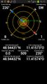
| Fri 22 Nov 2013 in 48,11: 48.9443124, 11.4157302 geohashing.info google osm bing/os kml crox |

Location
In a forest near Gelbelsee, close to the A9 motorway.
Participants
- OwlOnAWheel
- 1-0
- LeslieHapablap (previous|next)
- Waltraud the hashkiwi
Plans
Geohashing on the way to a juggling convention is becoming a tradition. Again the point is too close to the motorway to let it by, and this time there is the added fun of OwlOnAWheel having no idea what we are up to.
Expedition
- We have been there! Report and photos to follow. -- LeslieHapablap (talk) 00:13, 23 November 2013 (CET)
We started from Innsbruck with three people, two unicycles and one hashkiwi. The destination was a juggling convention in Nürnberg, about 300 km away. With a little bit more than one hour to go, we took an exit from the motorway and 1-0 navigated me through a small village and into the forest, following the GPS device. We had almost reached the coordinates already when OwlOnAWheel finally asked where we were actually going :)
We explained the concept of geohashing, and fortunately she did not declare us crazy right away. Instead the three of us and Waltraud marched into the forest, armed with juggling clubs and followed by suspicious looks (as usual) from someone working near the spot where we were heading to. The difficulty level of this particular hash was very low compared to other expeditions we have been on. There was a nice path leading almost right up to the coordinates, no steep terrain, no thick vegetation. A perfect place for juggling some clubs and stupidly grinning into the camera, both of which we did.
The fact that the photo gallery below exists is owed to the incredibly useful program PhotoRec (a desaster recovery tool). My SD card failed me badly (ironically while I was trying to backup my data), and with this tool I was able to recover about a year worth of photos which I thought were lost for good. Yes, I know a year without backup is pushing my luck, but right now I'm just happy to have the photos back.
Tracklog
Photos
Obligatory proof.
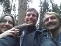
Obligatory silly grin picture.
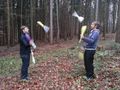
Once more juggling at a hashpoint.
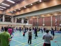
At the Nürnberg juggling convention.


Achievements
OwlOnAWheel, 1-0 and LeslieHapablap earned the Land geohash achievement
|
OwlOnAWheel, 1-0 and LeslieHapablap earned the Circus Geohash Achievement
|
1-0 and LeslieHapablap earned the Drag-along achievement
|
