Difference between revisions of "2013-12-12 41 -71"
imported>Vbob (→Expedition) |
m (Location correction) |
||
| (5 intermediate revisions by 4 users not shown) | |||
| Line 1: | Line 1: | ||
| − | |||
| − | |||
| − | |||
| − | |||
| − | |||
| − | |||
| − | |||
| − | |||
| − | |||
| − | |||
{{meetup graticule | {{meetup graticule | ||
| lat=41 | | lat=41 | ||
| Line 32: | Line 22: | ||
<!-- how it all turned out. your narrative goes here. --> | <!-- how it all turned out. your narrative goes here. --> | ||
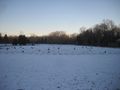
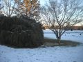
| − | Google Map view of this hash is very striking - appears to be off to the side of a very large, very modern, very active Veteran's cemetery. I had errands to do more or less half-way there, so headed out a bit early. Found the hash pretty easily - stood quietly with head bowed reverently over the GPS while a funeral drove past, then took some photos. A memorial tree and stone stand about 30' northeast of the precise hash, and I have nominated | + | Google Map view of this hash is very striking - appears to be off to the side of a very large, very modern, very active Veteran's cemetery. I had errands to do more or less half-way there, so headed out a bit early. Found the hash pretty easily - stood quietly with head bowed reverently over the GPS while a funeral drove past, then took some photos. A memorial tree and stone stand about 30' northeast of the precise hash, and I have nominated Ernest G. Chasse as an honorary hasher. I thought hard about the appropriateness of any kind of 'frivolous' activity here - then decided that many of these veterans had been sent to apparently random locations all over the world for reasons no more explicable than mine, and that 'leaving nothing but footprints' as our XKCD signature should not be considered disrespectful. |
== Tracklog == | == Tracklog == | ||
| Line 57: | Line 47: | ||
| − | |||
| − | |||
| − | |||
| − | |||
| − | |||
| − | |||
| − | |||
| − | |||
| − | |||
| − | |||
[[Category:Expeditions]] | [[Category:Expeditions]] | ||
| − | |||
[[Category:Expeditions with photos]] | [[Category:Expeditions with photos]] | ||
| − | |||
| − | |||
| − | |||
| − | |||
| − | |||
[[Category:Coordinates reached]] | [[Category:Coordinates reached]] | ||
| − | + | {{location|US|RI|WA}} | |
| − | |||
| − | |||
| − | |||
| − | |||
| − | |||
| − | |||
| − | |||
| − | |||
| − | |||
| − | |||
| − | |||
| − | |||
| − | |||
| − | |||
| − | |||
| − | |||
| − | |||
Latest revision as of 20:22, 16 May 2020
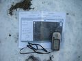
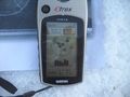
| Thu 12 Dec 2013 in 41,-71: 41.5448090, -71.5445031 geohashing.info google osm bing/os kml crox |
Location
Exeter, RI Veterans Cemetery
Participants
Plans
Expedition
Google Map view of this hash is very striking - appears to be off to the side of a very large, very modern, very active Veteran's cemetery. I had errands to do more or less half-way there, so headed out a bit early. Found the hash pretty easily - stood quietly with head bowed reverently over the GPS while a funeral drove past, then took some photos. A memorial tree and stone stand about 30' northeast of the precise hash, and I have nominated Ernest G. Chasse as an honorary hasher. I thought hard about the appropriateness of any kind of 'frivolous' activity here - then decided that many of these veterans had been sent to apparently random locations all over the world for reasons no more explicable than mine, and that 'leaving nothing but footprints' as our XKCD signature should not be considered disrespectful.
Tracklog
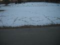
Photos

"recalculating"

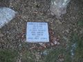
honorary hasher
leave nothing but footprints


