Difference between revisions of "2013-12-29 31 35"
imported>LiNaK m |
m (per Renaming Proposal) |
||
| (7 intermediate revisions by 2 users not shown) | |||
| Line 31: | Line 31: | ||
== Expedition == | == Expedition == | ||
| − | + | The photos are pretty safe-explanatory, so I'll make that one short (Yeah right. As if you're not gonna waste a whole evening for this report, just like with all the previous ones). We took three buses to Motsa, and found snow at Har'el Junction (That's extremely rare in Israel. Alexa storm was by far the snowiest storm in the Middle East since 1950. Usually snow doesn't fall in Jerusalem, and even when it does, it pretty much never stays there for two and a half weeks like it did this year). Than we walked from Motsa in a circular road around Beit Zait, which turned out to be much longer than we expected. We tried to short cut it a little when we started feeling like it wasn't actually leading us to the village itself, but every time we tried it we found a fence or an angry dog. Luckily for us, the way was pretty interesting, as we found a small "river" that was created by the storm, a stone-carved cave (we have no idea what was it built for. It was empty)and a useless dam (I actually knew about that one beforehand. It was built in the 50's to gather drinking water for Jerusalem, only to discover a few weeks later that the ground around it was very absorbent, so all the water just disappeared underground). We were also lucky because all along our walk it seemed like it's about to rain anytime, but rain did not occur all day long. | |
| + | |||
| + | Finally we found a route that seemed to go to the village, but after a few hundred meters it split into to roads. Of course, as considered adults, we solved the problem in the most reasonable way we could think of- tossing a coin. So we did that, and it worked (though to be fair, we think they both arrive at different parts of the village). We've heard before that Beit Zait is known for having a well preserved dinosaur footprint, but we didn't expect to be actually attacked by Velociraptors. After escaping them, we walked to the hashpoint itself, took some more pictures and than found the bus station, this time returning through Jerusalem, so we had a chance to see some more snow there. | ||
| Line 44: | Line 46: | ||
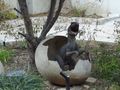
Image:2013-12-29_31_35_cute.jpg | We don't know who did this, but that is so cute! | Image:2013-12-29_31_35_cute.jpg | We don't know who did this, but that is so cute! | ||
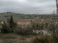
Image:2013-12-29_31_35_view.jpg | The road was longer than we expected. | Image:2013-12-29_31_35_view.jpg | The road was longer than we expected. | ||
| − | + | Image:2013-12-29_31_35_cave.jpg | We found a cave! | |
| + | Image:2013-12-29_31_35_cave2.jpg | Inside the cave. | ||
| + | Image:2013-12-29_31_35_river.jpg | We found a river! | ||
| + | Image:2013-12-29_31_35_river2.jpg | Walking along the river. | ||
| + | Image:2013-12-29_31_35_church.jpg | Moscovia Monastery and the Catholic Church of St. John the Baptist. | ||
| + | Image:2013-12-29_31_35_dam.jpg | The useless dam. | ||
| + | Image:2013-12-29_31_35_dino.jpg | A Velociraptor attacking us! | ||
| + | Image:2013-12-29_31_35_dino2.jpg | Oh no! More Velociraptors! | ||
| + | Image:2013-12-29_31_35_view2.jpg | View from Beit Zait. | ||
| + | Image:2013-12-29_31_35_hash.jpg | Finally! The hashpoint! | ||
| + | Image:2013-12-29_31_35_hash2.jpg | The hashpoint itself. | ||
| + | Image:2013-12-29_31_35_jeru.jpg | You can see Jerusalem from the hashpoint. | ||
| + | Image:2013-12-29_31_35_us.jpg | Lilac and Omri at the coordinates. | ||
| + | Image:2013-12-29_31_35_snow2.jpg | Snow in Jerusalem. | ||
| + | Image:2013-12-29_31_35_jeru2.jpg | Didn't have time to take more photos in Jerusalem. Sorry. | ||
| + | Image:2013-12-29_31_35_dead.jpg | Dead Sea-watch out! Someday we're gonna geohash in you and win the lowest geohash achievement. And it'll be awesome! | ||
</gallery> | </gallery> | ||
| Line 54: | Line 71: | ||
| longitude = 35 | | longitude = 35 | ||
| date = 2013-12-29 | | date = 2013-12-29 | ||
| − | | name = [[User:LiNaK|Omri]] | + | | name = [[User:LiNaK|Omri]] and Lilac |
| − | | image = | + | | image = 2013-12-29_31_35_dino.jpg |
}} | }} | ||
| − | {{ | + | {{Graticule unlocked |
| latitude = 31 | | latitude = 31 | ||
| longitude = 35 | | longitude = 35 | ||
| date = 2013-12-29 | | date = 2013-12-29 | ||
| − | | name = [[User:LiNaK|Omri]] | + | | name = [[User:LiNaK|Omri]] and Lilac |
| − | | image = | + | | image = 2013-12-29_31_35_us.jpg |
}} | }} | ||
| Line 72: | Line 89: | ||
| longitude = 35 | | longitude = 35 | ||
| date = 2013-12-29 | | date = 2013-12-29 | ||
| + | | name = [[User:LiNaK|Omri]] and Lilac | ||
| + | | description = in at a holy mountain, next to the Holy City, at the Holy Land, to more than one religion | ||
| + | | image = 2013-12-29_31_35_church.jpg | ||
| + | }} | ||
| + | |||
| + | |||
| + | {{Minesweeper geohash | ||
| + | | graticule = Jerusalem, Israel | ||
| + | | ranknumber = 3 | ||
| + | | n = true | ||
| + | | w = true | ||
| + | | nw = true | ||
| name = [[User:LiNaK|Omri]] | | name = [[User:LiNaK|Omri]] | ||
| − | |||
| − | |||
}} | }} | ||
| Line 82: | Line 109: | ||
[[Category:Expedition without GPS]] | [[Category:Expedition without GPS]] | ||
[[Category:Coordinates reached]] | [[Category:Coordinates reached]] | ||
| + | {{location|IL|JM}} | ||
Latest revision as of 05:16, 20 March 2024
| Sun 29 Dec 2013 in 31,35: 31.7846778, 35.1664268 geohashing.info google osm bing/os kml crox |
Location
At the forest right next to the road leading to Beit Zait, a small town on a hill facing Jerusalem.
Participants
Lilac
Plans
Bike to Lilac at Kiryat Ono, take a bus to Bar Ilan Bridge, another bus to Har'el Junction, and than another one to Ramat Motsa. From there we'll walk through the forst (or along the road) to Beit Zait. And than take three more buses home. And if we'll be lucky it won't even rain...
Expedition
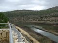
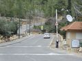
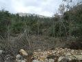
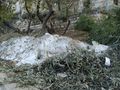
The photos are pretty safe-explanatory, so I'll make that one short (Yeah right. As if you're not gonna waste a whole evening for this report, just like with all the previous ones). We took three buses to Motsa, and found snow at Har'el Junction (That's extremely rare in Israel. Alexa storm was by far the snowiest storm in the Middle East since 1950. Usually snow doesn't fall in Jerusalem, and even when it does, it pretty much never stays there for two and a half weeks like it did this year). Than we walked from Motsa in a circular road around Beit Zait, which turned out to be much longer than we expected. We tried to short cut it a little when we started feeling like it wasn't actually leading us to the village itself, but every time we tried it we found a fence or an angry dog. Luckily for us, the way was pretty interesting, as we found a small "river" that was created by the storm, a stone-carved cave (we have no idea what was it built for. It was empty)and a useless dam (I actually knew about that one beforehand. It was built in the 50's to gather drinking water for Jerusalem, only to discover a few weeks later that the ground around it was very absorbent, so all the water just disappeared underground). We were also lucky because all along our walk it seemed like it's about to rain anytime, but rain did not occur all day long.
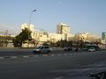
Finally we found a route that seemed to go to the village, but after a few hundred meters it split into to roads. Of course, as considered adults, we solved the problem in the most reasonable way we could think of- tossing a coin. So we did that, and it worked (though to be fair, we think they both arrive at different parts of the village). We've heard before that Beit Zait is known for having a well preserved dinosaur footprint, but we didn't expect to be actually attacked by Velociraptors. After escaping them, we walked to the hashpoint itself, took some more pictures and than found the bus station, this time returning through Jerusalem, so we had a chance to see some more snow there.
Photos
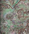
The map we used.
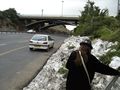
Snow! In Israel!
Along the road.
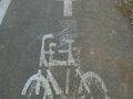
We don't know who did this, but that is so cute!
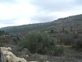
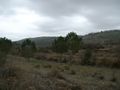
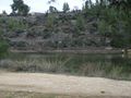
The road was longer than we expected.
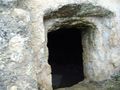
We found a cave!
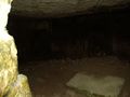
Inside the cave.
We found a river!
Walking along the river.
Moscovia Monastery and the Catholic Church of St. John the Baptist.
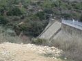
The useless dam.
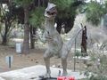
A Velociraptor attacking us!
Oh no! More Velociraptors!
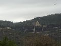
View from Beit Zait.
Finally! The hashpoint!
The hashpoint itself.
You can see Jerusalem from the hashpoint.
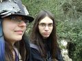
Lilac and Omri at the coordinates.
Snow in Jerusalem.
Didn't have time to take more photos in Jerusalem. Sorry.
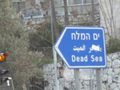
Dead Sea-watch out! Someday we're gonna geohash in you and win the lowest geohash achievement. And it'll be awesome!


Achievements
Omri and Lilac earned the Velociraptor Geohash Achievement
|
Omri and Lilac earned the Graticule Unlocked Achievement
|
Omri and Lilac earned the Holy hash achievement
|
Omri achieved level 3 of the Minesweeper Geohash achievement
|