Difference between revisions of "2014-01-20 52 1"
imported>Sourcerer m ([live] Arrived.) |
imported>FippeBot m (Location) |
||
| (4 intermediate revisions by one other user not shown) | |||
| Line 1: | Line 1: | ||
| − | |||
| − | |||
| − | |||
| − | |||
| − | |||
| − | |||
| − | |||
| − | |||
| − | |||
| − | |||
{{meetup graticule | {{meetup graticule | ||
| lat=52 | | lat=52 | ||
| lon=1 | | lon=1 | ||
| date=2014-01-20 | | date=2014-01-20 | ||
| + | | graticule_name=Norwich | ||
| + | | graticule_link=Norwich, United Kingdom | ||
}} | }} | ||
| − | |||
| − | |||
== Location == | == Location == | ||
| − | + | ||
| + | On a field boundary 75 metres west of Redisham road just south of Redisham village, Suffolk, UK. | ||
== Participants == | == Participants == | ||
| − | |||
| − | |||
| − | + | [[User:Sourcerer|Sourcerer]] | |
| − | |||
== Expedition == | == Expedition == | ||
| − | |||
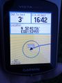
| + | *Arrived. -- [[User:Sourcerer|Sourcerer]] ([[User talk:Sourcerer|talk]]) [http://www.openstreetmap.org/?lat=52.40152895450592&lon=1.5395396947860718&zoom=16&layers=B000FTF @52.4015,1.5395] 16:44, 20 January 2014 (GMT) | ||
| + | |||
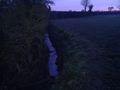
| + | This was an easy expedition. The hashpoint was 5 miles from home. There was a handy place to park at the entrance to the field. The hashpoint was on the field edge so it was easily reached without crop damage. The field was not fenced or gated. Google earth was unclear on which side of the drainage stream the hashpoint was. For once, quantum inconvenience seemed not to be operating. The hashpoint was on the easy-to-reach side of the stream. | ||
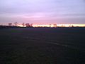
| − | + | There was a magnificent sunset with "Hound of the Baskerville" fog forming in the frost hollows and a deep red sky after the sun dipped below the horizon. | |
| − | |||
| − | |||
== Photos == | == Photos == | ||
| − | |||
| − | |||
| − | |||
<gallery perrow="5"> | <gallery perrow="5"> | ||
| + | Image:2014-01-20 52 1 Sourcerer 1.jpg | Proof | ||
| + | Image:2014-01-20 52 1 Sourcerer 2.jpg | The Hashpoint | ||
| + | Image:2014-01-20 52 1 Sourcerer 3.jpg | The Sunset | ||
</gallery> | </gallery> | ||
== Achievements == | == Achievements == | ||
| − | |||
| − | |||
| + | {{Sourcerer_links | ||
| + | | prev = 2014-01-19 52 1 | ||
| + | | curr = 2014-01-20 52 1 | ||
| + | | next = 2014-01-21 52 1 | ||
| + | | date = 2014-01-20 | ||
| + | }} | ||
| − | |||
| − | |||
| − | |||
| − | |||
| − | |||
| − | |||
| − | |||
| − | |||
| − | |||
| − | |||
[[Category:Expeditions]] | [[Category:Expeditions]] | ||
| − | |||
[[Category:Expeditions with photos]] | [[Category:Expeditions with photos]] | ||
| − | |||
| − | |||
| − | |||
| − | |||
| − | |||
[[Category:Coordinates reached]] | [[Category:Coordinates reached]] | ||
| − | + | {{location|GB|ENG|SFK}} | |
| − | |||
| − | |||
| − | |||
| − | |||
| − | |||
| − | |||
| − | |||
| − | |||
| − | |||
| − | |||
| − | |||
| − | |||
| − | |||
| − | |||
| − | |||
| − | |||
| − | |||
Latest revision as of 05:18, 14 August 2019
| Mon 20 Jan 2014 in Norwich: 52.4015294, 1.5395423 geohashing.info google osm bing/os kml crox |
Contents
Location
On a field boundary 75 metres west of Redisham road just south of Redisham village, Suffolk, UK.
Participants
Expedition
- Arrived. -- Sourcerer (talk) @52.4015,1.5395 16:44, 20 January 2014 (GMT)
This was an easy expedition. The hashpoint was 5 miles from home. There was a handy place to park at the entrance to the field. The hashpoint was on the field edge so it was easily reached without crop damage. The field was not fenced or gated. Google earth was unclear on which side of the drainage stream the hashpoint was. For once, quantum inconvenience seemed not to be operating. The hashpoint was on the easy-to-reach side of the stream.
There was a magnificent sunset with "Hound of the Baskerville" fog forming in the frost hollows and a deep red sky after the sun dipped below the horizon.
Photos
Proof
The Hashpoint
The Sunset


Achievements
Expeditions and Plans
| 2014-01-20 | ||
|---|---|---|
| Los Angeles, California | Bravissimo594 | In the dry South Fork River (wash) off of Railroad Ave. in Santa Clarita. |
| Springfield, Oregon | Anniepoo, Frogman, Alison, Kate | Just off hwy 20 east of Sweet Home. |
| Portland, Oregon | Michael5000 | In front of the "Wy'East Medical" building in the Clackamas warehouse distr... |
| Zürich, Switzerland | Chris 47 8, Calamus, Guga2112 | A park close to Milchbuck in Zurich. |
| Norwich, United Kingdom | Sourcerer | On a field boundary 75 metres west of Redisham road just south of Redisham ... |
Sourcerer's Expedition Links
2014-01-19 52 1 - 2014-01-20 52 1 - 2014-01-21 52 1 - KML file download of Sourcerer's expeditions for use with Google Earth.