Difference between revisions of "2014-02-03 44 -123"
imported>Frogman (→Achievements) |
imported>FippeBot m (Location) |
||
| (12 intermediate revisions by 3 users not shown) | |||
| Line 15: | Line 15: | ||
}} | }} | ||
| − | + | ||
__NOTOC__ | __NOTOC__ | ||
== Location == | == Location == | ||
| Line 21: | Line 21: | ||
== Participants == | == Participants == | ||
| − | + | ||
| − | *[[User:Frogman|Frogman]] | + | *[[User:Michael5000|Michael5000]] -- First Expedition - Expedition #156 |
| − | *Greg | + | |
| + | *[[User:Frogman|Frogman]] Second expedition | ||
| + | *Greg - Second Expedition | ||
== Plans == | == Plans == | ||
| Line 31: | Line 33: | ||
== Expedition == | == Expedition == | ||
| + | |||
| + | ===First Expedition=== | ||
| + | I had already decided to take the day off when I saw the likely looking hashpoint not far out of Corvallis. This offered me a chance to do two things that would satisfy my collector's impulse: (1) geohashing in Benton County and (2) run in Benton County. Yes, I have odd collections. | ||
| + | |||
| + | Knowing that Frogman would likely be interested, I had the choice between being civil and being mischievous. I went with the latter, driving down relatively early to be the first party there. I left evidence -- my calling card at the entrance to the land and a banner near the hashpoint -- and headed home without so much as a by-your-leave (after a lovely run on the trails of the Oregon State University forest). | ||
| + | |||
| + | When I told Frogman's sister what I had done, she said it was "cruel." No, I told her, it was "mischievous." "Cruel" would be getting there first and setting up a pit trap. | ||
| + | |||
===Second Expedition=== | ===Second Expedition=== | ||
I was going to ride my bike to the hashpoint after class, but Greg offered to drive us there. This was great, because it was cold! We drove up Highway 99, only getting a bit lost once, and pulled into a gravel road to continue the rest of the way on foot. But why were there small rectangular pieces of paper in the gate? [[User:Michael5000|Michael5000]] had been here already, it seems! We made remarks on how dedicated he must be, both to this sport and to showing us up, to have taken the drive down to Corvallis. And he didn't even visit! | I was going to ride my bike to the hashpoint after class, but Greg offered to drive us there. This was great, because it was cold! We drove up Highway 99, only getting a bit lost once, and pulled into a gravel road to continue the rest of the way on foot. But why were there small rectangular pieces of paper in the gate? [[User:Michael5000|Michael5000]] had been here already, it seems! We made remarks on how dedicated he must be, both to this sport and to showing us up, to have taken the drive down to Corvallis. And he didn't even visit! | ||
| Line 36: | Line 46: | ||
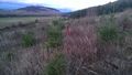
The hashpoint itself was a short trek up the hill from there. The area was logged so we were met with fantastic views of the sunset. | The hashpoint itself was a short trek up the hill from there. The area was logged so we were met with fantastic views of the sunset. | ||
| − | |||
| − | |||
== Photos == | == Photos == | ||
| − | |||
| − | |||
| − | |||
<gallery perrow="5"> | <gallery perrow="5"> | ||
| + | File:2014-02-03 44 -123 flag.JPG| A flag, near the hashpoint in a bush that would keep it from tipping over. | ||
| + | File:2014-02-03 44 -123 M5K.JPG| Expedition 1's goofy grin. | ||
Image:2014-02-03 44 -123 driving.jpg | Driving to the hashpoint! | Image:2014-02-03 44 -123 driving.jpg | Driving to the hashpoint! | ||
Image:2014-02-03 44 -123 road.jpg | Highway 99. | Image:2014-02-03 44 -123 road.jpg | Highway 99. | ||
| Line 50: | Line 57: | ||
Image:2014-02-03 44 -123 north.jpg | The view to the north of the hashpoint. | Image:2014-02-03 44 -123 north.jpg | The view to the north of the hashpoint. | ||
Image:2014-02-03 44 -123 south.jpg | The view to the south, up a hill. | Image:2014-02-03 44 -123 south.jpg | The view to the south, up a hill. | ||
| + | Image:2014-02-03 44 -123 proof.jpg | Proof! | ||
Image:2014-02-03 44 -123 marker.jpg | A flag was there, marking the hashpoint. Well, within GPS margin-of-error at least. | Image:2014-02-03 44 -123 marker.jpg | A flag was there, marking the hashpoint. Well, within GPS margin-of-error at least. | ||
Image:2014-02-03 44 -123 grins.jpg | Expedition 2's goofy grins. | Image:2014-02-03 44 -123 grins.jpg | Expedition 2's goofy grins. | ||
| Line 56: | Line 64: | ||
== Achievements == | == Achievements == | ||
{{#vardefine:ribbonwidth|800px}} | {{#vardefine:ribbonwidth|800px}} | ||
| − | |||
| − | [[ | + | {{Regional geohashing |
| + | | name = Michael5000 | ||
| + | | region = Benton County, Oregon | ||
| + | | count = 1 | ||
| + | | image = M5K Benton.jpg | ||
| + | }} | ||
| + | |||
| + | *Michael5000's first return to the Eugene graticule since Expedition #1, [[2009-10-31 44 -123]]. | ||
| + | *Michael5000's first expedition to Benton County. | ||
| + | |||
[[Category:Expeditions]] | [[Category:Expeditions]] | ||
[[Category:Expeditions with photos]] | [[Category:Expeditions with photos]] | ||
[[Category:Coordinates reached]] | [[Category:Coordinates reached]] | ||
| + | {{location|US|OR|BE}} | ||
Latest revision as of 05:24, 14 August 2019
| Mon 3 Feb 2014 in 44,-123: 44.6794904, -123.2483381 geohashing.info google osm bing/os kml crox |
Location
In a field west of Adair Village, Oregon.
Participants
- Michael5000 -- First Expedition - Expedition #156
- Frogman Second expedition
- Greg - Second Expedition
Plans
I will probably bike up here after class. Frogman (talk) 13:29, 3 February 2014 (EST)
- Oh good. Michael5000 (talk) 16:43, 3 February 2014 (EST)
Expedition
First Expedition
I had already decided to take the day off when I saw the likely looking hashpoint not far out of Corvallis. This offered me a chance to do two things that would satisfy my collector's impulse: (1) geohashing in Benton County and (2) run in Benton County. Yes, I have odd collections.
Knowing that Frogman would likely be interested, I had the choice between being civil and being mischievous. I went with the latter, driving down relatively early to be the first party there. I left evidence -- my calling card at the entrance to the land and a banner near the hashpoint -- and headed home without so much as a by-your-leave (after a lovely run on the trails of the Oregon State University forest).
When I told Frogman's sister what I had done, she said it was "cruel." No, I told her, it was "mischievous." "Cruel" would be getting there first and setting up a pit trap.
Second Expedition
I was going to ride my bike to the hashpoint after class, but Greg offered to drive us there. This was great, because it was cold! We drove up Highway 99, only getting a bit lost once, and pulled into a gravel road to continue the rest of the way on foot. But why were there small rectangular pieces of paper in the gate? Michael5000 had been here already, it seems! We made remarks on how dedicated he must be, both to this sport and to showing us up, to have taken the drive down to Corvallis. And he didn't even visit!
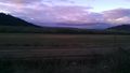
The hashpoint itself was a short trek up the hill from there. The area was logged so we were met with fantastic views of the sunset.
Photos
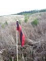
A flag, near the hashpoint in a bush that would keep it from tipping over.
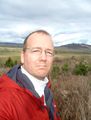
Expedition 1's goofy grin.
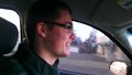
Driving to the hashpoint!
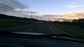
Highway 99.
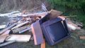
There was a pile of junk sitting close to where we parked.
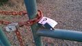
Someone got here first!
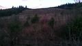
The view to the north of the hashpoint.
The view to the south, up a hill.
Proof!
A flag was there, marking the hashpoint. Well, within GPS margin-of-error at least.

Expedition 2's goofy grins.


Achievements
Michael5000 earned the Regional geohashing achievement
|
- Michael5000's first return to the Eugene graticule since Expedition #1, 2009-10-31 44 -123.
- Michael5000's first expedition to Benton County.