2014-02-03 47 -122
| Mon 3 Feb 2014 in Seattle: 47.6794904, -122.2483381 geohashing.info google osm bing/os kml crox |
Location
Magnuson Park, south of the Kite Hill and north of the Boat Launch. Fairly close to the Swimming Beach.
Participants
Plans
Stop by on the way to work for Seattle's 180th expedition and likely 126th success.
- This is such a cool spot I'll have to go get it as well... will aim for 5pm or a little before. (Didn't go for yesterday's because I was sleeping off a stubborn bug...) -- OtherJack (talk) 15:56, 3 February 2014 (EST)
Expedition
I commute to work between Ballard and Bothell, and usually take Lake City Way then state highway 522. Magnuson park is not strictly on-the-way, but it's not far off - and this evening I will have other commitments.
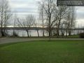
Magnuson Park was originally shared by two Native American tribes. More recently, it was a park named Carkeek (the same as near my house) until bought up by the city to create a Naval Air Station after World War I. This facility was deactivated in 1970 and most of it became Magnuson Park. Many of the buildings used for that are still there, including large hangars that are now used as indoor sports fields. Also there are some pretty cool and very accessible wetlands - recommended for a visit if you are in the graticule.
The park neighborhood was easy to reach, with a little south-bound traffic on the drive - people headed to work. Entered the park from the north entrance and drove past a baseball field I have worked often and will probably be umping high school baseball at in the next few months. Good day for a game actually, if a little cold.
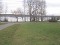
Reached the Cross Park Trail and parked - the parking doesn't match the google aerial photo used on Peeron - this area now has angled spots on one side of the road only. Much safer, in general. Walked across the lawn to reach the spot, snapping a few photos on the way.
Geohash dance gets me to a measurement of less than a meter to the spot - well within the 2-3 meter error rate of the device. Seems like Android has me a few meters south of the spot as pictured on google, but one or both may be off. Have discussed this with others and their full GPS devices - it seems like there may be a way to reset Android measurements for accuracy. Will research that soon.
Off to work, exiting via the south entrance and heading north again - no Tron for this trip.
Photos
Parked by CrossPark Trail
Geohash ahead
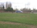
Mode of transportation
Good morning! @47.6795,-122.2483


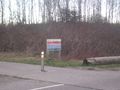
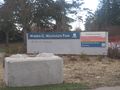
North entrance to facility
South entrance


