Difference between revisions of "2014-03-15 -43 172"
imported>Quaternary (Created page with " <!-- [[Image:{{{image|2014_03_15_-43_172_.JPG}}}|thumb|left]] And DON'T FORGET to add your expedition and the best photo you took to the gallery on the Main Page! We'd lov...") |
imported>Quaternary |
||
| Line 1: | Line 1: | ||
| + | |||
| + | |||
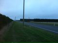
| + | [[Image:{{{image|2014_03_15_-43_172_Looking_East.JPG}}}|thumb|left]] | ||
<!-- | <!-- | ||
| − | |||
| − | |||
And DON'T FORGET to add your expedition and the best photo you took to the gallery on the Main Page! We'd love to read your report, but that means we first have to discover it! :) | And DON'T FORGET to add your expedition and the best photo you took to the gallery on the Main Page! We'd love to read your report, but that means we first have to discover it! :) | ||
--> | --> | ||
| Line 25: | Line 26: | ||
== Plans == | == Plans == | ||
| − | Having a BBQ with friends to celebrate the end of the summer, when we realised that there was a roadside geohash a mere 14km to the North- | + | Having a BBQ with friends to celebrate the end of the summer, when we realised that there was a roadside geohash a mere 14km to the North-West! |
== Expedition == | == Expedition == | ||
| − | After the BBQ we thought we'd dash out before | + | After the BBQ's first-course, we thought we'd dash out before dessert, while there was still some light. Typically, it started to rain as we left! |
We dragged one of our friends with us on this quest, and it did take a bit of explaining. | We dragged one of our friends with us on this quest, and it did take a bit of explaining. | ||
| Line 39: | Line 40: | ||
== Tracklog == | == Tracklog == | ||
| − | |||
<gallery> | <gallery> | ||
Image:2014_03_15_-43_172_Geolocation.PNG | | Image:2014_03_15_-43_172_Geolocation.PNG | | ||
| + | Image:2014_03_15_-43_172_Arrived.PNG | | ||
| + | |||
</gallery> | </gallery> | ||
| Line 50: | Line 52: | ||
<gallery perrow="4"> | <gallery perrow="4"> | ||
| − | Image:2014_03_15_- | + | Image:2014_03_15_-43_172_The_Marker.JPG | Our marker |
| + | Image:2014_03_15_-43_172_Photographing_The_Marker.jpg | Documenting the marker's resting spot! | ||
| + | Image:2014_03_15_-43_172_The_Location.JPG | "What are we doing here again? (At least its stopped raining, I guess)" | ||
| + | Image:2014_03_15_-43_172_Looking_East.JPG | "Looking towards the East, as the light fades" | ||
| + | Image:2014_03_15_-43_172_Looking_West.JPG | "Looking towards the West, as the light fades a bit more" | ||
</gallery> | </gallery> | ||
| − | |||
== Achievements == | == Achievements == | ||
Revision as of 10:28, 15 March 2014

| Sat 15 Mar 2014 in -43,172: -43.4083609, 172.4902828 geohashing.info google osm bing/os kml crox |
Location
Swannanoa/Eyreton, Canterbury, New Zealand
Participants
The Quaternary (talk) family geohashers
Plans
Having a BBQ with friends to celebrate the end of the summer, when we realised that there was a roadside geohash a mere 14km to the North-West!
Expedition
After the BBQ's first-course, we thought we'd dash out before dessert, while there was still some light. Typically, it started to rain as we left!
We dragged one of our friends with us on this quest, and it did take a bit of explaining.
This was on a grass verge beside a country road, just next to the hedge. This was extraordinarily reminescent of our last geohash, but at least this time the hedge was not prickley - just common old pinus radiata.
Grabbed a few quick pics as the light started to fade.
Tracklog


Photos
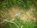
Our marker
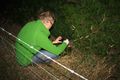
Documenting the marker's resting spot!
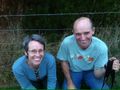
"What are we doing here again? (At least its stopped raining, I guess)"
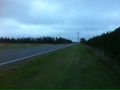
"Looking towards the East, as the light fades"
"Looking towards the West, as the light fades a bit more"


Achievements
Quaternary earned the GeoTrash Geohash Achievement
|