Difference between revisions of "2014-03-20 45 -122"
From Geohashing
imported>Michael5000 m (→Participants) |
imported>FippeBot m (Location) |
||
| (10 intermediate revisions by 2 users not shown) | |||
| Line 1: | Line 1: | ||
| − | |||
| − | [[ | + | [[File:2014-03-20 45 -122.JPG|left|thumb|400px|This car is passing over the hashpoint at ~60 miles per hour.]] |
| − | |||
| − | |||
| − | |||
| − | |||
{{meetup graticule | {{meetup graticule | ||
| lat=45 | | lat=45 | ||
| Line 22: | Line 17: | ||
== Participants == | == Participants == | ||
| − | + | ===Expedition5000=== | |
| − | * [[User:Michael5000|Michael5000]] | + | * [[User:Michael5000|Michael5000]] - Expedition 159 |
| − | + | ===Expedition the Second=== | |
| − | + | * [[User:Frogman|Frogman]] | |
| − | + | * [[User:Benture|Benture]] | |
| + | * Leah | ||
| + | * Kate | ||
| + | * Daisy | ||
== Expedition == | == Expedition == | ||
| − | + | ===Expedition5000=== | |
| − | + | I drove down at lunch and parked in the driveway of a nearby church. It's a very busy location without much of interest, so I took my picture and left. | |
| − | == | + | ===Expedition the Second=== |
| − | + | We drove down in the evening. We didn't have a lot of time to spare, so we drove through the hashpoint. | |
== Photos == | == Photos == | ||
| − | |||
| − | |||
| − | |||
<gallery perrow="5"> | <gallery perrow="5"> | ||
| + | File:2014-03-20 45 -122.JPG|It is 16 miles from Oregon City to Mollala on Highway 213. | ||
| + | Image:2014-03-20 45 -122 daisy and leah.jpg | Leah and Daisy! | ||
| + | Image:2014-03-20 45 -122 on the way.jpg | We were driving the maximum legal speed limit somewhere before the hashpoint! Does that count for the achievement? | ||
| + | Image:2014-03-20 45 -122 hashpoint.jpg | At the hashpoint. | ||
| + | Image:2014-03-20 45 -122 grins.jpg | Goofy grins! | ||
| + | Image:2014-03-20 45 -122 sign.jpg | A picture of the intersection. | ||
| + | Image:2014-03-20 45 -122 castle.jpg | This nearby building looked like a castle. | ||
</gallery> | </gallery> | ||
| Line 45: | Line 47: | ||
<!-- Add any achievement ribbons you earned below, or remove this section --> | <!-- Add any achievement ribbons you earned below, or remove this section --> | ||
| + | {{Reverse Regional | ||
| + | | latitude = 45 | ||
| + | | longitude = -122 | ||
| + | | name = [[User:Frogman|Frogman]] | ||
| + | | count = four | ||
| + | | graticule = Portland, OR | ||
| + | | level = congressional district | ||
| + | }} | ||
| − | |||
| − | |||
| − | |||
| − | |||
| − | |||
| − | |||
| − | |||
| − | |||
| − | |||
| − | |||
| − | |||
[[Category:Expeditions]] | [[Category:Expeditions]] | ||
| − | |||
[[Category:Expeditions with photos]] | [[Category:Expeditions with photos]] | ||
| − | |||
| − | |||
| − | |||
| − | |||
| − | |||
[[Category:Coordinates reached]] | [[Category:Coordinates reached]] | ||
| − | + | {{location|US|OR|CC}} | |
| − | |||
| − | |||
| − | |||
| − | |||
| − | |||
| − | |||
| − | |||
| − | |||
| − | |||
| − | |||
| − | |||
| − | |||
| − | |||
| − | |||
| − | |||
| − | |||
| − | |||
Latest revision as of 05:56, 14 August 2019

| Thu 20 Mar 2014 in 45,-122: 45.3093655, -122.5686626 geohashing.info google osm bing/os kml crox |
Location
At the intersection of Highway 213 and Henrici Road, southeast of Oregon City.
Participants
Expedition5000
- Michael5000 - Expedition 159
Expedition the Second
Expedition
Expedition5000
I drove down at lunch and parked in the driveway of a nearby church. It's a very busy location without much of interest, so I took my picture and left.
Expedition the Second
We drove down in the evening. We didn't have a lot of time to spare, so we drove through the hashpoint.
Photos
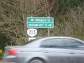
It is 16 miles from Oregon City to Mollala on Highway 213.
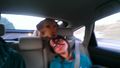
Leah and Daisy!
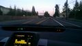
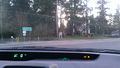
We were driving the maximum legal speed limit somewhere before the hashpoint! Does that count for the achievement?
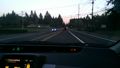
At the hashpoint.
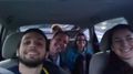
Goofy grins!
A picture of the intersection.
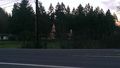
This nearby building looked like a castle.


Achievements
Frogman earned the Reverse regional achievement
|