Difference between revisions of "2014-08-17 49 -123"
imported>Rhonda (template) |
m (More specific location) |
||
| (8 intermediate revisions by 4 users not shown) | |||
| Line 19: | Line 19: | ||
== Location == | == Location == | ||
<!-- where you've surveyed the hash to be --> | <!-- where you've surveyed the hash to be --> | ||
| + | |||
| + | In the bus stop at 43rd and Main, Vancouver. | ||
== Participants == | == Participants == | ||
<!-- who attended: If you link to your wiki user name in this section, your expedition will be picked up by the various statistics generated for geohashing. You may use three tildes ~ as a shortcut to automatically insert the user signature of the account you are editing with. | <!-- who attended: If you link to your wiki user name in this section, your expedition will be picked up by the various statistics generated for geohashing. You may use three tildes ~ as a shortcut to automatically insert the user signature of the account you are editing with. | ||
--> | --> | ||
| + | |||
| + | * [[User:Rhonda|Rhonda]] | ||
| + | * [[User:Robyn|Robyn]] | ||
== Plans == | == Plans == | ||
<!-- what were the original plans --> | <!-- what were the original plans --> | ||
| + | Ride bike there after [[2009-08-30 49 -123|playing tag]], take pictures, then ride home. ETA at hashpoint, 4:30-ish (because tag ends at 4). Hope somebody else can make it. | ||
== Expedition == | == Expedition == | ||
<!-- how it all turned out. your narrative goes here. --> | <!-- how it all turned out. your narrative goes here. --> | ||
| + | ===Rhonda=== | ||
| + | I had an uneventful ride, almost entirely on marked and traffic-calmed bike routes. There were a lot of people out on bikes because it was a beautiful day. I left home early so I could visit [http://www.aboriginalbc.com/klahowya-village Klahowya Village] before going to [http://www.meetup.com/play-tag tag], and I learned that the peaks we call The Lions were originally called "the Twin Sisters" by the Squamish nation, and had a legend behind the name. Then I went from there to tag, played for two hours (with many water-and-shade breaks between games, because it was hot), then rode to the hashpoint. | ||
| + | |||
| + | I reached the bus stop at the hashpoint almost exactly at 4:30. There was a lady waiting for the bus, and she asked me something about when the bus would come, but I told her I didn't know because I was riding my bike, not taking the bus. The bus picked her up moments later, and I had to meet the driver's eye and shake my head to tell him I wasn't getting on. This happened four times in the 15-20 minutes I was there. I guess all the bus drivers figured (quite reasonably) that I was standing at the bus stop with my bike because I wanted to take the bus somewhere. | ||
| − | == | + | Google shows the actual hashpoint in the middle of the bus bay, next to the bus stop pole. However, as Main street is a busy street, busses seem to come every 4 minutes or so, and I got 2m from destination on my GPS while standing on the sidewalk, I decided that in the interests of safety I would declare the hashpoint reached without stepping into traffic. That would have been harder to justify if it were in one of the centre lanes: then I may have had to press the pedestrian signal at 43rd and make the traffic stop so I could get onto the road. |
| − | + | ||
| + | Sophie and I chalked the sidewalk and took pictures, then shared a cookie and got back on the bike to go home. As I pedalled slowly up the Lions Gate bridge, I realized that I was really tired. But then, with nearly three hours of cycling plus two hours of tag, it shouldn't have surprised me. | ||
| + | |||
| + | ===Robyn=== | ||
| + | I was at work, as I have been every day this month, and most of the previous, when Rhonda e-mailed me to point out how close the geohash was. I wasn't actually flying an airplane at the time, so I received the e-mail, but the day's flying didn't take us anywhere near it. By the end of the day I'd been at work for almost twelve hours, and knew there was no food in the house, because I've been away working, and Wade was away, too. So on the way home from work I found a parking spot at Fraser and 45th, and ordered take-out at the nearest restaurant. The restaurateur told me it would be ready in ten minutes, so I said, "I'll be back. I just have to do something." | ||
| + | |||
| + | It never seems right to drive to a geohash. So I ran from 45th and Fraser to 43rd and Main, wearing my work boots, found the spot, and ran back. It took my thirteen minutes, but the restaurateur didn't mind. The food turns out to be REALLY good, I'm eating it now. Little restaurant with Arabic writing on the door, right by the bus stop at 45th and Fraser, just south of the library. | ||
== Photos == | == Photos == | ||
| Line 37: | Line 53: | ||
Image:2012-##-## ## ## Alpha.jpg | Witty Comment | Image:2012-##-## ## ## Alpha.jpg | Witty Comment | ||
--> | --> | ||
| − | <gallery | + | <gallery> |
| + | Image:2014-08-17 49 -123 gps.JPG | This looks like the place! | ||
| + | Image:2014-08-17 49 -123 chalkmark.JPG | xkcd marks the spot... or close to it | ||
| + | Image:2014-08-17 looking north.JPG | Looking north from just south of the hashpoint | ||
| + | Image:2014-08-17 49 -123 looking south.JPG | Looking south from the sidewalk beside the hashpoint | ||
| + | Image:2014-08-17 49 -123 grin.JPG | obligatory stupid grin :) | ||
| + | File:2014-08-17 49 -123.robyn 001.JPG | Quick shot before running back to pick up my take-out | ||
| + | |||
</gallery> | </gallery> | ||
| − | |||
| − | |||
| − | |||
| − | |||
| − | |||
| − | |||
| − | |||
| − | <!-- == | + | <!-- =============== USEFUL CATEGORIES FOLLOW ================--> |
| − | |||
| − | |||
| − | |||
| − | |||
| − | |||
[[Category:Expeditions]] | [[Category:Expeditions]] | ||
| − | |||
[[Category:Expeditions with photos]] | [[Category:Expeditions with photos]] | ||
| − | |||
| − | |||
| − | |||
| − | |||
[[Category:Coordinates reached]] | [[Category:Coordinates reached]] | ||
| − | + | {{location|CA|BC|MV}} | |
| − | |||
| − | |||
| − | |||
| − | |||
| − | |||
| − | |||
| − | |||
| − | |||
| − | |||
| − | |||
| − | |||
| − | |||
| − | |||
| − | |||
| − | |||
| − | |||
| − | |||
Latest revision as of 00:08, 10 August 2020
| Sun 17 Aug 2014 in 49,-123: 49.2306145, -123.1015844 geohashing.info google osm bing/os kml crox |
Location
In the bus stop at 43rd and Main, Vancouver.
Participants
Plans
Ride bike there after playing tag, take pictures, then ride home. ETA at hashpoint, 4:30-ish (because tag ends at 4). Hope somebody else can make it.
Expedition
Rhonda
I had an uneventful ride, almost entirely on marked and traffic-calmed bike routes. There were a lot of people out on bikes because it was a beautiful day. I left home early so I could visit Klahowya Village before going to tag, and I learned that the peaks we call The Lions were originally called "the Twin Sisters" by the Squamish nation, and had a legend behind the name. Then I went from there to tag, played for two hours (with many water-and-shade breaks between games, because it was hot), then rode to the hashpoint.
I reached the bus stop at the hashpoint almost exactly at 4:30. There was a lady waiting for the bus, and she asked me something about when the bus would come, but I told her I didn't know because I was riding my bike, not taking the bus. The bus picked her up moments later, and I had to meet the driver's eye and shake my head to tell him I wasn't getting on. This happened four times in the 15-20 minutes I was there. I guess all the bus drivers figured (quite reasonably) that I was standing at the bus stop with my bike because I wanted to take the bus somewhere.
Google shows the actual hashpoint in the middle of the bus bay, next to the bus stop pole. However, as Main street is a busy street, busses seem to come every 4 minutes or so, and I got 2m from destination on my GPS while standing on the sidewalk, I decided that in the interests of safety I would declare the hashpoint reached without stepping into traffic. That would have been harder to justify if it were in one of the centre lanes: then I may have had to press the pedestrian signal at 43rd and make the traffic stop so I could get onto the road.
Sophie and I chalked the sidewalk and took pictures, then shared a cookie and got back on the bike to go home. As I pedalled slowly up the Lions Gate bridge, I realized that I was really tired. But then, with nearly three hours of cycling plus two hours of tag, it shouldn't have surprised me.
Robyn
I was at work, as I have been every day this month, and most of the previous, when Rhonda e-mailed me to point out how close the geohash was. I wasn't actually flying an airplane at the time, so I received the e-mail, but the day's flying didn't take us anywhere near it. By the end of the day I'd been at work for almost twelve hours, and knew there was no food in the house, because I've been away working, and Wade was away, too. So on the way home from work I found a parking spot at Fraser and 45th, and ordered take-out at the nearest restaurant. The restaurateur told me it would be ready in ten minutes, so I said, "I'll be back. I just have to do something."
It never seems right to drive to a geohash. So I ran from 45th and Fraser to 43rd and Main, wearing my work boots, found the spot, and ran back. It took my thirteen minutes, but the restaurateur didn't mind. The food turns out to be REALLY good, I'm eating it now. Little restaurant with Arabic writing on the door, right by the bus stop at 45th and Fraser, just south of the library.
Photos
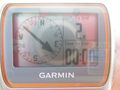
This looks like the place!
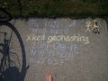
xkcd marks the spot... or close to it
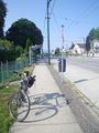
Looking north from just south of the hashpoint
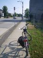
Looking south from the sidewalk beside the hashpoint
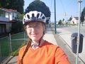
obligatory stupid grin :)
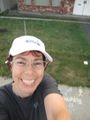
Quick shot before running back to pick up my take-out


