Difference between revisions of "2015-01-13 52 1"
imported>Sourcerer m (→Added Achievement) |
imported>FippeBot m (Location) |
||
| (2 intermediate revisions by one other user not shown) | |||
| Line 3: | Line 3: | ||
| lon=1 | | lon=1 | ||
| date=2015-01-13 | | date=2015-01-13 | ||
| + | | graticule_name=Norwich, UK | ||
| + | | graticule_link=Norwich, United Kingdom | ||
}} | }} | ||
| − | |||
__NOTOC__ | __NOTOC__ | ||
| − | |||
== Location == | == Location == | ||
| Line 41: | Line 41: | ||
}} | }} | ||
| − | == | + | {{Sourcerer_links |
| − | + | | prev = 2015-01-10 52 1 | |
| − | + | | curr = 2015-01-13 52 1 | |
| + | | next = 2015-01-15 52 0 | ||
| + | | date = 2015-01-13 | ||
| + | }} | ||
[[Category:Expeditions]] | [[Category:Expeditions]] | ||
[[Category:Expeditions with photos]] | [[Category:Expeditions with photos]] | ||
[[Category:Coordinates reached]] | [[Category:Coordinates reached]] | ||
| + | {{location|GB|ENG|SFK}} | ||
Latest revision as of 02:24, 15 August 2019
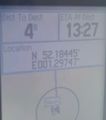
| Tue 13 Jan 2015 in Norwich, UK: 52.1844166, 1.2974203 geohashing.info google osm bing/os kml crox |
Location
65 metres south of the public footpath close to the church of St Andrew and St Eustachius, Kettleburgh, Suffolk, UK.
Participants
Expedition
- Arrived. -- Sourcerer (talk) @52.1849,1.2972 13:17, 13 January 2015 (GMT)
In a short period of sparkling January sunshine, Sourcerer set out by car, heading south towards the hashpoint. It was another soggy, almost get stuck parking place. The hashpoint was about 65 metres south of the public footpath next to the church. There was a bit of dithering before locating tractor tracks which enabled the hashpoint to be reached without treading on the winter wheat seedlings. There was clay in the soil and huge clods built up under my all terrain sandals. The temperature was 8.5 C and the wind was much more gentle although more storm winds are forecast.
The weather was deteriorating fast and back home, the rain tipped down while making this report.
Photos
Proof
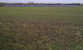
Photovoltaics in the next field
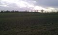
The hashpoint and tractor tracks


Achievements
Sourcerer earned the OpenStreetMap achievement
|
Expeditions and Plans
| 2015-01-13 | ||
|---|---|---|
| Wien, Austria | micsnare | Trauttmansdorffgasse -- Hietzing (13th District), Vienna |
| Norwich, United Kingdom | Sourcerer | 65 metres south of the public footpath close to the church of St Andrew and... |
Sourcerer's Expedition Links
2015-01-10 52 1 - 2015-01-13 52 1 - 2015-01-15 52 0 - KML file download of Sourcerer's expeditions for use with Google Earth.