Difference between revisions of "2015-01-25 52 1"
imported>Sourcerer m ([live picture] [http://www.openstreetmap.org/?lat=52.79080868&lon=1.26726866&zoom=16&layers=B000FTF @52.7908,1.2673]) |
imported>FippeBot m (Location) |
||
| (7 intermediate revisions by one other user not shown) | |||
| Line 1: | Line 1: | ||
| − | |||
| − | |||
| − | |||
| − | |||
| − | |||
| − | |||
| − | |||
| − | |||
| − | |||
| − | |||
{{meetup graticule | {{meetup graticule | ||
| lat=52 | | lat=52 | ||
| lon=1 | | lon=1 | ||
| date=2015-01-25 | | date=2015-01-25 | ||
| + | | graticule_name=Norwich, UK | ||
| + | | graticule_link=Norwich, United Kingdom | ||
}} | }} | ||
| − | |||
| − | |||
__NOTOC__ | __NOTOC__ | ||
== Location == | == Location == | ||
| − | + | ||
| + | In a field, close to the A140, east of Aylsham, Norfolk, UK. | ||
== Participants == | == Participants == | ||
| − | |||
| − | |||
| − | + | * [[User:Sourcerer|Sourcerer]] | |
| − | + | * [[User:Sourcerer|Sourcerer]] again on 2015-11-29 (Retro expedition) | |
== Expedition == | == Expedition == | ||
| − | |||
| + | *Arrived. -- [[User:Sourcerer|Sourcerer]] ([[User talk:Sourcerer|talk]]) [http://www.openstreetmap.org/?lat=52.79100180&lon=1.26705408&zoom=16&layers=B000FTF @52.7910,1.2671] 12:04, 25 January 2015 (GMT) | ||
| + | |||
| + | This hashpoint was quite close to Wroxham, home of Roy's, where you can buy less usual items. I needed a replacement kitchen sieve and this was all the excuse I needed to launch this expedition. | ||
| + | |||
| + | I got close enough to the hashpoint for the flag to sit on the circumference of the circle of uncertainty. There were no obstructions and ten paces into the field would get me to the zero point. I didn't bother. | ||
| − | + | On the return run, I got my new sieve. No more injuries washing up the old one which had broken wires. | |
| − | + | ||
| − | + | The retro visit required a 40 metre walk, deviating from the route from [[2015-11-29 52 1]] to [[2015-11-30 52 1]]. | |
== Photos == | == Photos == | ||
| Line 39: | Line 32: | ||
Image:2012-##-## ## ## Alpha.jpg | Witty Comment | Image:2012-##-## ## ## Alpha.jpg | Witty Comment | ||
--> | --> | ||
| − | <gallery perrow=" | + | <gallery perrow="2"> |
| − | + | Image:2015-01-25_52_1_Sourcerer_1422187557221.jpg | Proof - [http://www.openstreetmap.org/?lat=52.79094815&lon=1.26702189&zoom=16&layers=B000FTF @52.7909,1.2670] | |
| − | Image:2015-01-25_52_1_Sourcerer_1422187557221.jpg | [http://www.openstreetmap.org/?lat=52.79094815&lon=1.26702189&zoom=16&layers=B000FTF @52.7909,1.2670] | + | Image:2015-01-25_52_1_Sourcerer_1422187711000.jpg | View of the point - [http://www.openstreetmap.org/?lat=52.79080868&lon=1.26726866&zoom=16&layers=B000FTF @52.7908,1.2673] |
| − | + | Image:2015-01-25 52 1 Retro Proof.jpg | Retro proof | |
| − | Image:2015-01-25_52_1_Sourcerer_1422187711000.jpg | [http://www.openstreetmap.org/?lat=52.79080868&lon=1.26726866&zoom=16&layers=B000FTF @52.7908,1.2673] | + | Image:2015-01-25 52 1 Retro.jpg | Retro Track in Google Earth |
</gallery> | </gallery> | ||
| − | == | + | {{Sourcerer_links |
| − | + | | prev = 2015-01-22 52 1 | |
| − | + | | curr = 2015-01-25 52 1 | |
| + | | next = 2015-01-26 52 1 | ||
| + | | date = 2015-01-25 | ||
| + | }} | ||
| − | |||
| − | |||
| − | |||
| − | |||
| − | |||
| − | |||
| − | |||
| − | |||
| − | |||
| − | |||
| − | |||
| − | |||
| − | |||
[[Category:Expeditions]] | [[Category:Expeditions]] | ||
| − | |||
[[Category:Expeditions with photos]] | [[Category:Expeditions with photos]] | ||
| − | |||
| − | |||
| − | |||
| − | |||
| − | |||
[[Category:Coordinates reached]] | [[Category:Coordinates reached]] | ||
| − | + | [[Category:Retro meetup]] | |
| − | + | [[Category:Retro coordinates reached]] | |
| − | + | {{location|GB|ENG|NFK}} | |
| − | |||
| − | |||
| − | |||
| − | |||
| − | |||
| − | |||
| − | [[Category: | ||
| − | |||
| − | |||
| − | [[Category: | ||
| − | |||
| − | |||
| − | |||
| − | |||
| − | |||
Latest revision as of 02:33, 15 August 2019
| Sun 25 Jan 2015 in Norwich, UK: 52.7910748, 1.2671470 geohashing.info google osm bing/os kml crox |
Location
In a field, close to the A140, east of Aylsham, Norfolk, UK.
Participants
Expedition
- Arrived. -- Sourcerer (talk) @52.7910,1.2671 12:04, 25 January 2015 (GMT)
This hashpoint was quite close to Wroxham, home of Roy's, where you can buy less usual items. I needed a replacement kitchen sieve and this was all the excuse I needed to launch this expedition.
I got close enough to the hashpoint for the flag to sit on the circumference of the circle of uncertainty. There were no obstructions and ten paces into the field would get me to the zero point. I didn't bother.
On the return run, I got my new sieve. No more injuries washing up the old one which had broken wires.
The retro visit required a 40 metre walk, deviating from the route from 2015-11-29 52 1 to 2015-11-30 52 1.
Photos
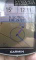
Proof - @52.7909,1.2670
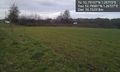
View of the point - @52.7908,1.2673
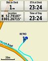
Retro proof
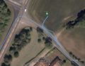
Retro Track in Google Earth


Expeditions and Plans
| 2015-01-25 | ||
|---|---|---|
| Melbourne East, Australia | Kozz | Up a driveway in Croydon |
| Long Beach, California | Bravissimo594 | Sidewalk on the Pacific Coast Highway in Wilmington or San Pedro. Long Beach graticule... |
| Atlanta, Georgia | NWoodruff, NWoodruff's son. | On the back lot of a performance school in Decatur. |
| Enterprise, Oregon | Anniepoo | Alongside highway 3 N of Enterprise on the road to Lewiston Looks fairly e... |
| Norwich, United Kingdom | Sourcerer | In a field, close to the A140, east of Aylsham, Norfolk, UK. |
Sourcerer's Expedition Links
2015-01-22 52 1 - 2015-01-25 52 1 - 2015-01-26 52 1 - KML file download of Sourcerer's expeditions for use with Google Earth.