Difference between revisions of "2015-02-07 52 1"
imported>Sourcerer m ([live] Arrived.) |
imported>FippeBot m (Location) |
||
| (4 intermediate revisions by one other user not shown) | |||
| Line 1: | Line 1: | ||
| − | |||
| − | |||
| − | |||
| − | |||
| − | |||
| − | |||
| − | |||
| − | |||
| − | |||
| − | |||
{{meetup graticule | {{meetup graticule | ||
| lat=52 | | lat=52 | ||
| lon=1 | | lon=1 | ||
| date=2015-02-07 | | date=2015-02-07 | ||
| + | | graticule_name=Norwich, UK | ||
| + | | graticule_link=Norwich, United Kingdom | ||
}} | }} | ||
| − | |||
| − | |||
__NOTOC__ | __NOTOC__ | ||
== Location == | == Location == | ||
| − | + | ||
| + | In a field near a pool between Sotherton and Brampton, Sufolk, UK. | ||
== Participants == | == Participants == | ||
| − | |||
| − | |||
| − | + | [[User:Sourcerer|Sourcerer]] | |
| − | |||
== Expedition == | == Expedition == | ||
| − | |||
| + | *Arrived. -- [[User:Sourcerer|Sourcerer]] ([[User talk:Sourcerer|talk]]) [http://www.openstreetmap.org/?lat=52.36207902&lon=1.56185567&zoom=16&layers=B000FTF @52.3621,1.5619] 19:05, 7 February 2015 (GMT) | ||
| − | + | This was 10 km from home and easily reached. The hashpoint access was along two sides of a field with wide margins containing pheasant feeders and long grass cover. Then there was another pool, very similar to one a few days ago. Some of these pools may have been made in olden times to provide drinking for livestock. Some are more recent. During world war two, aricraft sometimes got disoriented and dropped bombs in completely the wrong place. These made craters similar in size to today's pool. From here it was twenty paces into a ploughed field. Tonight it was much darker. The full moon had gone and the waning orb does not rise so early in the night. | |
| − | + | ||
| − | + | Sadly the Norwich hashpoints for the next two days fall in the North sea. The Cambridge points don't look too inviting. One might be a pig farm and the other is in a drainage ditch. | |
== Photos == | == Photos == | ||
| − | + | ||
| − | |||
| − | |||
<gallery perrow="5"> | <gallery perrow="5"> | ||
| − | |||
Image:2015-02-07_52_1_Sourcerer_1423335859540.jpg | Proof [http://www.openstreetmap.org/?lat=52.36207902&lon=1.56185031&zoom=16&layers=B000FTF @52.3621,1.5619] | Image:2015-02-07_52_1_Sourcerer_1423335859540.jpg | Proof [http://www.openstreetmap.org/?lat=52.36207902&lon=1.56185031&zoom=16&layers=B000FTF @52.3621,1.5619] | ||
| + | Image:2015-02-07 52 1 Sourcerer.jpg | Track Log | ||
</gallery> | </gallery> | ||
== Achievements == | == Achievements == | ||
{{#vardefine:ribbonwidth|800px}} | {{#vardefine:ribbonwidth|800px}} | ||
| − | |||
| + | {{Sourcerer_links | ||
| + | | prev = 2015-02-06 52 1 | ||
| + | | curr = 2015-02-07 52 1 | ||
| + | | next = 2015-02-09 52 0 | ||
| + | | date = 2015-02-07 | ||
| + | }} | ||
| − | |||
| − | |||
| − | |||
| − | |||
| − | |||
| − | |||
| − | |||
| − | |||
| − | |||
| − | |||
| − | |||
| − | |||
[[Category:Expeditions]] | [[Category:Expeditions]] | ||
| − | |||
[[Category:Expeditions with photos]] | [[Category:Expeditions with photos]] | ||
| − | |||
| − | |||
| − | |||
| − | |||
| − | |||
[[Category:Coordinates reached]] | [[Category:Coordinates reached]] | ||
| − | + | {{location|GB|ENG|SFK}} | |
| − | |||
| − | |||
| − | |||
| − | |||
| − | |||
| − | |||
| − | |||
| − | |||
| − | |||
| − | |||
| − | |||
| − | |||
| − | |||
| − | |||
| − | |||
| − | |||
| − | |||
Latest revision as of 02:39, 15 August 2019
| Sat 7 Feb 2015 in Norwich, UK: 52.3620723, 1.5619110 geohashing.info google osm bing/os kml crox |
Location
In a field near a pool between Sotherton and Brampton, Sufolk, UK.
Participants
Expedition
- Arrived. -- Sourcerer (talk) @52.3621,1.5619 19:05, 7 February 2015 (GMT)
This was 10 km from home and easily reached. The hashpoint access was along two sides of a field with wide margins containing pheasant feeders and long grass cover. Then there was another pool, very similar to one a few days ago. Some of these pools may have been made in olden times to provide drinking for livestock. Some are more recent. During world war two, aricraft sometimes got disoriented and dropped bombs in completely the wrong place. These made craters similar in size to today's pool. From here it was twenty paces into a ploughed field. Tonight it was much darker. The full moon had gone and the waning orb does not rise so early in the night.
Sadly the Norwich hashpoints for the next two days fall in the North sea. The Cambridge points don't look too inviting. One might be a pig farm and the other is in a drainage ditch.
Photos
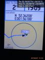
Proof @52.3621,1.5619
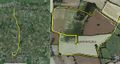
Track Log


Achievements
Expeditions and Plans
| 2015-02-07 | ||
|---|---|---|
| St. Louis, Missouri | Kbh3rd | In a field just off of the Hillsboro-House Springs Road in Jefferson County... |
| Newark, New Jersey | Zubenelgenubi | At about 40 and sunny, it was a good day for a walk. I had seen a creeks on... |
| Buffalo, New York | Pedalpusher, Simon the dog | In the woods North of Ashford, NY |
| Zürich, Switzerland | Chris 47 8 | Hegibachplatz in Zürich |
| Kassel, Germany | GeorgDerReisende | The hash lies in Fuldatal-Wahnhausen, between the national road and the cyc... |
| Norwich, United Kingdom | Sourcerer | In a field near a pool between Sotherton and Brampton, Sufolk, UK. |
Sourcerer's Expedition Links
2015-02-06 52 1 - 2015-02-07 52 1 - 2015-02-09 52 0 - KML file download of Sourcerer's expeditions for use with Google Earth.