Difference between revisions of "2015-02-23 52 1"
From Geohashing
imported>Sourcerer m ([live] Arrived.) |
imported>Sourcerer m (→New expedition) |
||
| Line 7: | Line 7: | ||
== Location == | == Location == | ||
| − | + | A roadside hashpoint east of Ufford, Suffolk, UK. | |
== Participants == | == Participants == | ||
| Line 17: | Line 17: | ||
Planning two hashpoints spanning midnight: [[2015-02-22 51 1]] :: [[2015-02-23 52 1]] | Planning two hashpoints spanning midnight: [[2015-02-22 51 1]] :: [[2015-02-23 52 1]] | ||
| + | *Arrived. -- [[User:Sourcerer|Sourcerer]] ([[User talk:Sourcerer|talk]]) 00:11, 23 February 2015 (GMT) | ||
| + | |||
| + | This was an easy one. It was very close to my route home from the 51,1 hashpoint before midnight. I was expecting problems reaching the point but there was an unmapped kink in the road. I didn't even need to get out of the car. On my Garmin GPS, the distance dropped to one metre before going back up to 5. My HTC phone lost its GPS lock under the wet trees. The wet conditions and road works speed limits made me a bit late for an exact midnight hash but it was near enough. | ||
| − | |||
== Photos == | == Photos == | ||
<gallery perrow="5"> | <gallery perrow="5"> | ||
| − | + | Image:2015-02-23_52_1_Sourcerer_1424650145647.jpg | Proof | |
| − | + | Image:2015-02-23 52 1 Sourcerer 2.jpg | Track Log | |
| − | Image:2015-02- | ||
</gallery> | </gallery> | ||
| Line 30: | Line 31: | ||
{{#vardefine:ribbonwidth|800px}} | {{#vardefine:ribbonwidth|800px}} | ||
| − | |||
{{consecutive geohash 2 | {{consecutive geohash 2 | ||
| count = 9 | | count = 9 | ||
| Line 38: | Line 38: | ||
| name = Sourcerer | | name = Sourcerer | ||
}} | }} | ||
| − | -- | + | {{Midnight geohash |
| + | | latitude = 52 | ||
| + | | longitude = 1 | ||
| + | | date = 2015-02-23 | ||
| + | | name = Sourcerer | ||
| + | }} | ||
| + | |||
== Other geohashing expeditions on the same day == | == Other geohashing expeditions on the same day == | ||
{{expedition summaries|2015-02-23}} | {{expedition summaries|2015-02-23}} | ||
| − | |||
| − | |||
[[Category:Expeditions]] | [[Category:Expeditions]] | ||
[[Category:Expeditions with photos]] | [[Category:Expeditions with photos]] | ||
[[Category:Coordinates reached]] | [[Category:Coordinates reached]] | ||
| − | |||
Revision as of 01:43, 23 February 2015
| Mon 23 Feb 2015 in 52,1: 52.1268527, 1.3553267 geohashing.info google osm bing/os kml crox |
Location
A roadside hashpoint east of Ufford, Suffolk, UK.
Participants
Expedition
Planning two hashpoints spanning midnight: 2015-02-22 51 1 :: 2015-02-23 52 1
This was an easy one. It was very close to my route home from the 51,1 hashpoint before midnight. I was expecting problems reaching the point but there was an unmapped kink in the road. I didn't even need to get out of the car. On my Garmin GPS, the distance dropped to one metre before going back up to 5. My HTC phone lost its GPS lock under the wet trees. The wet conditions and road works speed limits made me a bit late for an exact midnight hash but it was near enough.
Photos
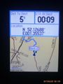
Proof
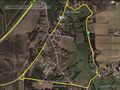
Track Log


Achievements
Sourcerer earned the Consecutive geohash achievement
|
Sourcerer earned the Midnight Geohash achievement
|
Other geohashing expeditions on the same day
Expeditions and Plans
| 2015-02-23 | ||
|---|---|---|
| München, Germany | Thomcat | Between a road and a pedestrian path in Germering, near München. |
| Norwich, United Kingdom | Sourcerer | A roadside hashpoint east of Ufford, Suffolk, UK. |
| Hannover, Germany | Fippe | located on a sheepwalk near Hameln. |