Difference between revisions of "2015-04-16 52 1"
From Geohashing
imported>Sourcerer m (→Expedition Addition) |
imported>Sourcerer m (→Links) |
||
| Line 31: | Line 31: | ||
</gallery> | </gallery> | ||
| − | == | + | {{Sourcerer_links |
| − | + | | prev = 2015-04-11 52 1 | |
| − | + | | curr = 2015-04-16 52 1 | |
| + | | next = 2015-04-17 52 1 | ||
| + | | date = 2015-04-16 | ||
| + | }} | ||
[[Category:Expeditions]] | [[Category:Expeditions]] | ||
[[Category:Expeditions with photos]] | [[Category:Expeditions with photos]] | ||
[[Category:Coordinates reached]] | [[Category:Coordinates reached]] | ||
Revision as of 18:06, 16 June 2015
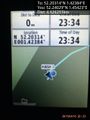
| Thu 16 Apr 2015 in 52,1: 52.2031393, 1.4238443 geohashing.info google osm bing/os kml crox |
Location
In a field, close to the road, south of Great Glemham, Suffolk, UK.
Participants
Expedition
This was expedition one of two spanning midnight - 2015-04-16 52 1 - 2015-04-17 52 1 - The points were close together.
- Arrived. -- Sourcerer (talk) @52.2032,1.4238 23:35, 16 April 2015 (GMT+01:00)
The hashpoint was on a well trodden path behind some houses and on the perimeter of the field. It was a cold starry night with a breeze, moderated by shelter from trees and the hedgerow.
3G access was intermittent. I was able to upload the "Arrived" message but the photo upload had to wait until I reached the next hashpoint 4.6 km away.
Photos
Proof. @52.2403,1.4542
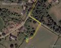
Google Earth Track Log


Expeditions and Plans
| 2015-04-16 | ||
|---|---|---|
| Springfield, Illinois | Mystrsyko | In a farm field just off Route 97 |
| New York, New York | OtherJack | About a meter east of the Metro-North railroad tracks in Mt. Vernon. |
| Goslar, Germany | GeorgDerReisende | The hash lay in a foregarden of a house in the Schneidemühlenweg in Mühlhau... |
| Norwich, United Kingdom | Sourcerer | In a field, close to the road, south of Great Glemham, Suffolk, UK. |
Sourcerer's Expedition Links
2015-04-11 52 1 - 2015-04-16 52 1 - 2015-04-17 52 1 - KML file download of Sourcerer's expeditions for use with Google Earth.