Difference between revisions of "2015-04-22 47 -122"
imported>Thomcat ([live picture] [http://www.openstreetmap.org/?lat=47.30134751&lon=-122.33743220&zoom=16&layers=B000FTF @47.3013,-122.3374]) |
imported>FippeBot m (Location) |
||
| (4 intermediate revisions by one other user not shown) | |||
| Line 18: | Line 18: | ||
== Expedition == | == Expedition == | ||
| − | + | Got a slightly late start and found myself at the appointed 7-11 just past 2. Bought a reasonably sized geosquishy and found the trail leading south easily enough. The sun dappled trail was paved with blacktop, and I regretted not bringing along sidewalk chalk to mark the spot. | |
| + | |||
| + | 800 or so meters later I spotted where the walkway came to a T junction; just back from this point (and still in the woods) I would find the hashpoint, just off the trail. Indeed I did so, quite easily, and snapped appropriate pictures. I spilled some squishy on the path, but really don't expect anyone else to stroll by this spot today/tonight. | ||
| + | |||
| + | On the way back, I walked through the apartment complex and noted the water feature shown on the map. Nice enough place to live, with a geohash fairly close by - today anyways. | ||
== Tracklog == | == Tracklog == | ||
| Line 36: | Line 40: | ||
Image:2015-04-22_47_-122_thomcat_1429737762795.jpg | [http://www.openstreetmap.org/?lat=47.30134751&lon=-122.33743220&zoom=16&layers=B000FTF @47.3013,-122.3374] | Image:2015-04-22_47_-122_thomcat_1429737762795.jpg | [http://www.openstreetmap.org/?lat=47.30134751&lon=-122.33743220&zoom=16&layers=B000FTF @47.3013,-122.3374] | ||
| + | |||
| + | Image:2015-04-22_47_-122_thomcat_1429737893263.jpg | [http://www.openstreetmap.org/?lat=47.30133990&lon=-122.33741385&zoom=16&layers=B000FTF @47.3013,-122.3374] | ||
| + | |||
| + | Image:2015-04-22_47_-122_thomcat_1429738096797.jpg | Nearby water feature [http://www.openstreetmap.org/?lat=47.30336925&lon=-122.33654710&zoom=16&layers=B000FTF @47.3034,-122.3365] | ||
</gallery> | </gallery> | ||
| Line 41: | Line 49: | ||
{{#vardefine:ribbonwidth|800px}} | {{#vardefine:ribbonwidth|800px}} | ||
<!-- Add any achievement ribbons you earned below, or remove this section --> | <!-- Add any achievement ribbons you earned below, or remove this section --> | ||
| + | {{GeoSquishy 5Star | ||
| + | | latitude = 47 | ||
| + | | longitude = -122 | ||
| + | | date = 2015-04-22 | ||
| + | | name = Thomcat | ||
| + | | image = 2015-04-22_47_-122_thomcat_1429737255970.jpg | ||
| − | + | }} | |
| − | |||
[[Category:Expeditions]] | [[Category:Expeditions]] | ||
| − | |||
[[Category:Expeditions with photos]] | [[Category:Expeditions with photos]] | ||
| − | |||
| − | |||
| − | |||
| − | |||
| − | |||
[[Category:Coordinates reached]] | [[Category:Coordinates reached]] | ||
| − | + | {{location|US|WA|KN}} | |
| − | |||
| − | |||
| − | |||
| − | |||
| − | |||
| − | |||
| − | |||
| − | |||
| − | |||
| − | |||
| − | |||
| − | |||
| − | |||
| − | |||
| − | |||
| − | |||
| − | |||
Latest revision as of 03:25, 15 August 2019
| Wed 22 Apr 2015 in Seattle: 47.3013559, -122.3374364 geohashing.info google osm bing/os kml crox |
Location
Earth day in Federal Way, just off the West Campus Trail.
Participants
Plans
Going to park at the 7-11 just north of point, then walk down the trail. Should be on-point at roughly 2pm.
Expedition
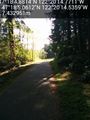
Got a slightly late start and found myself at the appointed 7-11 just past 2. Bought a reasonably sized geosquishy and found the trail leading south easily enough. The sun dappled trail was paved with blacktop, and I regretted not bringing along sidewalk chalk to mark the spot.
800 or so meters later I spotted where the walkway came to a T junction; just back from this point (and still in the woods) I would find the hashpoint, just off the trail. Indeed I did so, quite easily, and snapped appropriate pictures. I spilled some squishy on the path, but really don't expect anyone else to stroll by this spot today/tonight.
On the way back, I walked through the apartment complex and noted the water feature shown on the map. Nice enough place to live, with a geohash fairly close by - today anyways.
Tracklog
Photos
Path intersection ahead @47.3014,-122.3374
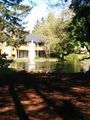
Nearby water feature @47.3034,-122.3365


Achievements
Thomcat earned the 5 Star GeoSquishy Achievement
|